%20ammap.com%20%7C%20SVG%20map%20of%20Philippines%20-%20High%20--%3E%0A%3Csvg%20xmlns%3D%22http%3A%2F%2Fwww.w3.org%2F2000%2Fsvg%22%20xmlns%3Aamcharts%3D%22http%3A%2F%2Famcharts.com%2Fammap%22%20xmlns%3Axlink%3D%22http%3A%2F%2Fwww.w3.org%2F1999%2Fxlink%22%20version%3D%221.1%22%20viewBox%3D%220%200%20820%201250%22%20width%3D%22100%25%22%20height%3D%22100%25%22%20preserveAspectRatio%3D%22xMidYMid%20slice%22%3E%0A%09%3Cdefs%3E%0A%09%09%0A%0A%09%09%3Camcharts%3Aammap%20projection%3D%22mercator%22%20leftLongitude%3D%22116.927573%22%20topLatitude%3D%2220.834769%22%20rightLongitude%3D%22126.606549%22%20bottomLatitude%3D%224.640292%22%3E%3C%2Famcharts%3Aammap%3E%0A%0A%09%09%3C!--%20All%20areas%20are%20listed%20in%20the%20line%20below.%20You%20can%20use%20this%20list%20in%20your%20script.%20--%3E%0A%09%09%3C!--%7Bid%3A%22PH-SUR%22%7D%2C%7Bid%3A%22PH-TAR%22%7D%2C%7Bid%3A%22PH-TAW%22%7D%2C%7Bid%3A%22PH-ZMB%22%7D%2C%7Bid%3A%22PH-ZAN%22%7D%2C%7Bid%3A%22PH-ZSI%22%7D%2C%7Bid%3A%22PH-ABR%22%7D%2C%7Bid%3A%22PH-AGN%22%7D%2C%7Bid%3A%22PH-AGS%22%7D%2C%7Bid%3A%22PH-AKL%22%7D%2C%7Bid%3A%22PH-ALB%22%7D%2C%7Bid%3A%22PH-ANT%22%7D%2C%7Bid%3A%22PH-APA%22%7D%2C%7Bid%3A%22PH-AUR%22%7D%2C%7Bid%3A%22PH-BAN%22%7D%2C%7Bid%3A%22PH-BTN%22%7D%2C%7Bid%3A%22PH-BTG%22%7D%2C%7Bid%3A%22PH-BEN%22%7D%2C%7Bid%3A%22PH-BIL%22%7D%2C%7Bid%3A%22PH-BOH%22%7D%2C%7Bid%3A%22PH-BUK%22%7D%2C%7Bid%3A%22PH-BUL%22%7D%2C%7Bid%3A%22PH-CAG%22%7D%2C%7Bid%3A%22PH-CAN%22%7D%2C%7Bid%3A%22PH-CAS%22%7D%2C%7Bid%3A%22PH-CAM%22%7D%2C%7Bid%3A%22PH-CAP%22%7D%2C%7Bid%3A%22PH-CAT%22%7D%2C%7Bid%3A%22PH-CAV%22%7D%2C%7Bid%3A%22PH-CEB%22%7D%2C%7Bid%3A%22PH-COM%22%7D%2C%7Bid%3A%22PH-DAV%22%7D%2C%7Bid%3A%22PH-DAS%22%7D%2C%7Bid%3A%22PH-DAO%22%7D%2C%7Bid%3A%22PH-DIN%22%7D%2C%7Bid%3A%22PH-EAS%22%7D%2C%7Bid%3A%22PH-GUI%22%7D%2C%7Bid%3A%22PH-IFU%22%7D%2C%7Bid%3A%22PH-ILN%22%7D%2C%7Bid%3A%22PH-ILS%22%7D%2C%7Bid%3A%22PH-ILI%22%7D%2C%7Bid%3A%22PH-ISA%22%7D%2C%7Bid%3A%22PH-KAL%22%7D%2C%7Bid%3A%22PH-LUN%22%7D%2C%7Bid%3A%22PH-LAG%22%7D%2C%7Bid%3A%22PH-LAN%22%7D%2C%7Bid%3A%22PH-LAS%22%7D%2C%7Bid%3A%22PH-LEY%22%7D%2C%7Bid%3A%22PH_MG%22%7D%2C%7Bid%3A%22PH-MAD%22%7D%2C%7Bid%3A%22PH-MAS%22%7D%2C%7Bid%3A%22PH-MNL%22%7D%2C%7Bid%3A%22PH-MSC%22%7D%2C%7Bid%3A%22PH-MSR%22%7D%2C%7Bid%3A%22PH-MOU%22%7D%2C%7Bid%3A%22PH-NEC%22%7D%2C%7Bid%3A%22PH-NER%22%7D%2C%7Bid%3A%22PH-NCO%22%7D%2C%7Bid%3A%22PH-NSA%22%7D%2C%7Bid%3A%22PH-NUE%22%7D%2C%7Bid%3A%22PH-NUV%22%7D%2C%7Bid%3A%22PH-MDC%22%7D%2C%7Bid%3A%22PH-MDR%22%7D%2C%7Bid%3A%22PH-PLW%22%7D%2C%7Bid%3A%22PH-PAM%22%7D%2C%7Bid%3A%22PH-PAN%22%7D%2C%7Bid%3A%22PH-QUE%22%7D%2C%7Bid%3A%22PH-QUI%22%7D%2C%7Bid%3A%22PH-RIZ%22%7D%2C%7Bid%3A%22PH-ROM%22%7D%2C%7Bid%3A%22PH-WSA%22%7D%2C%7Bid%3A%22PH-SAR%22%7D%2C%7Bid%3A%22PH-SIG%22%7D%2C%7Bid%3A%22PH-SOR%22%7D%2C%7Bid%3A%22PH-SCO%22%7D%2C%7Bid%3A%22PH-SLE%22%7D%2C%7Bid%3A%22PH-SUK%22%7D%2C%7Bid%3A%22PH-SLU%22%7D%2C%7Bid%3A%22PH-SUN%22%7D%2C%7Bid%3A%22PH-BAS%22%7D%2C%7Bid%3A%22PH-ZAS%22%7D--%3E%0A%0A%09%3C%2Fdefs%3E%0A%09%3Cg%3E%0A%09%09%3Cpath%20fill%3D%22white%22%20stroke%3D%22none%22%20id%3D%22PH-SUR%22%20title%3D%22Surigao%20del%20Sur%22%20%20d%3D%22M697.34%2C868.78l2.26%2C1.56l0.67%2C0.3l-0.92%2C0.84l-1.71%2C-0.44l-1.92%2C1.12l-0.1%2C1.14l1.66%2C1.7l1.02%2C-0.44l1.2%2C2.28l2.03%2C-0.97l-0.33%2C-1.19l1.14%2C-0.74l-0.05%2C1.74l-1.29%2C0.87l1.21%2C2.22l2.46%2C5.08l-0.96%2C0.08l3.07%2C2.42l5.07%2C-1.64l3.61%2C-3.78l2.82%2C0.11l-1.15%2C1.38l0.45%2C1.28l-1.73%2C4.96l0.42%2C3.07l-1.52%2C4.17l2.28%2C2.12l0.54%2C-1.12l2.92%2C5.03l2.83%2C2.9l0.95%2C0.33l1.33%2C1.52l0.24%2C1.56l-1.43%2C0.65l2.52%2C0.57l-1.33%2C2.76l2.02%2C2.94l-1.45%2C0.26l0.89%2C0.85l-1.96%2C1.44l0.2%2C1.58l-3.57%2C0.77l-1.15%2C0.75l-0.08%2C1.64l-1.81%2C0.61l-0.02%2C1.49l2.38%2C1.16l-4.19%2C-0.18l-5.97%2C3.46l-1.61%2C2.84l3.08%2C2.11l-0.83%2C1.24l2.16%2C2.61l1.45%2C-0.08l-0.26%2C-0.77l4.29%2C1.34l0.44%2C-0.69l-2.82%2C-1.26l1.61%2C-0.61l3.87%2C0.55l1.95%2C1.54l1.84%2C-0.69l1.69%2C0.64l1.21%2C-1.35l0.68%2C0.83l-0.82%2C1.34l2.86%2C0.18l0.4%2C1.74l-0.97%2C0.73l1.01%2C1.09l-2.5%2C-0.34l-1.07%2C3.16l1.85%2C-0.18l0.5%2C1.56l-1.73%2C2.96l-2.72%2C0.94l1.34%2C1.63l-0.79%2C0.3l0.25%2C1.17l3.31%2C0.3l0.99%2C1.32l-5.44%2C4.67l2.14%2C3.2l3.37%2C-1.44l3.59%2C-3.16l1.21%2C0.18l-2.04%2C9.59l1.73%2C1.05l-2.67%2C3.17l0.52%2C2.98l-1.17%2C0.3l0.67%2C1.82l2.46%2C-0.25l-3.13%2C2.49h-1.41l-1.93%2C3.22l0%2C0l-0.7%2C-6.63l0%2C0l-0.39%2C-3.68l-3.31%2C-1.01l4.35%2C-4.24l-4.81%2C0.51l-4.43%2C-4.21l-1.88%2C-0.26l1.04%2C-3.75l3.67%2C-4.18l1.38%2C-0.03l0.03%2C-1.74l-1.69%2C-2.12l0.86%2C-4.63l-1.47%2C2.12l-5.79%2C0.38l-5.89%2C-0.71l-2.79%2C-2.72l3.51%2C-3.9l-4.81%2C0.46l-1.25%2C-7.6l-1.8%2C-0.14l-0.16%2C-1.06l-0.38%2C-4.65l1.71%2C-1.16l-0.26%2C-0.84l-3.11%2C-4.7l-1.64%2C-5.7l-3.57%2C-4.09l-1.46%2C-14.2l-3.16%2C-5.48l-5.76%2C-6.65l0%2C0l-0.54%2C-6.53l0%2C0l12.34%2C-12.47l0%2C0L697.34%2C868.78z%22%2F%3E%0A%09%09%3Cpath%20fill%3D%22white%22%20stroke%3D%22none%22%20id%3D%22PH-TAR%22%20title%3D%22Tarlac%22%20%20d%3D%22M312.23%2C398.57L315.23%2C411.22L318.34%2C414.5L322.49%2C415.63L320.16%2C419.8L323.27%2C429.65L321.65%2C432.29L321.41%2C435.57L324.51%2C437.92L323.78%2C440.84L323.78%2C440.84L321.75%2C441.15L321.55%2C439.9L318.48%2C441.6L315.5%2C440.55L314.12%2C441.47L309.39%2C441.44L295.97%2C448.51L294.67%2C448.3L294.67%2C448.3L292.25%2C443.47L288.47%2C439.22L279.6%2C433.89L281.25%2C422.9L283.88%2C417.77L286.88%2C416.02L286.18%2C414.58L286.18%2C414.58L291.26%2C412.22L290.74%2C410.86L293.29%2C408.66L293.78%2C406.23L296.25%2C403.56L302.67%2C406.24L307.52%2C403.17L310.43%2C394.3z%22%2F%3E%0A%09%09%3Cpath%20fill%3D%22white%22%20stroke%3D%22none%22%20id%3D%22PH-TAW%22%20title%3D%22Tawi-Tawi%22%20%20d%3D%22M225.73%2C1211.16l-1.45%2C7.03l-0.56%2C-2.53l1.03%2C-1.87l-1.39%2C-1.19l2.42%2C-3.16L225.73%2C1211.16zM255.17%2C1206.92l2.96%2C2.03l-3.77%2C-0.16l-0.54%2C-1.43L255.17%2C1206.92zM228.27%2C1200.34l2.82%2C5.67l0.89%2C5.45l-1.83%2C6.65l-1.67%2C1.91l0.5%2C-10.77l-1.53%2C-8.06L228.27%2C1200.34zM253.4%2C1199.52l3.63%2C1.87l0.02%2C2.55l-3.61%2C0.54l-0.99%2C-4.28L253.4%2C1199.52zM269.12%2C1193.39l-0.9%2C3.46l-1.41%2C0.29l0.24%2C-3.5L269.12%2C1193.39zM251.6%2C1191.86l-0.42%2C1.37l-2.56%2C-0.2l0.32%2C-1.39L251.6%2C1191.86zM276.58%2C1191.94l1.12%2C0.67l-0.21%2C1.15l-2.58%2C-2.03L276.58%2C1191.94zM283.97%2C1192.26l-0.7%2C0.69l-2.11%2C-0.57l1.76%2C-1.56l1.4%2C0.76L283.97%2C1192.26zM253.96%2C1185.49l0.52%2C4.34l-1.15%2C0.52l-0.75%2C-0.95l-0.4%2C1.67l-3.17%2C0.46l1.94%2C-4.56L253.96%2C1185.49zM290.23%2C1185.16l0.64%2C1.47l-1.18%2C0.84l-2.56%2C-0.14L290.23%2C1185.16zM292.85%2C1183.39l-0.58%2C1.95l-1.1%2C-0.38l0.15%2C-2.17l1.14%2C-0.5L292.85%2C1183.39zM290.25%2C1179.95l-2.56%2C1.53l-0.45%2C-1.01l-1.55%2C0.35l1.66%2C-5.24l2.83%2C2.42L290.25%2C1179.95zM294%2C1175.44l-1.54%2C5.38l-0.66%2C-2.93L294%2C1175.44zM283.03%2C1168.83l0.34%2C3.42l2.8%2C1.87l-1.7%2C3.07l0.65%2C3.73l-1.49%2C2.53l0.34%2C1.65l-4.17%2C-1.47l1.98%2C-2.81l-1.72%2C-0.73l-0.85%2C2.17l-2.6%2C-1.67l-1.81%2C2.58l-0.77%2C-0.7l-0.89%2C-0.54l-1.09%2C0.42l-0.17%2C-1.28l-1.24%2C-0.08l-3.19%2C1.92l0.3%2C1.71l-0.66%2C0.62l-2.17%2C3.31l-2.2%2C-0.78l-3%2C1.72l-0.6%2C0.34l-1.49%2C0.9l-2.93%2C-0.64l0.35%2C-3.99l-1.02%2C-1.01l1.38%2C-1.75l1.99%2C0.2l6.09%2C-3.07l2.75%2C-3.5l3.65%2C0.36l2.9%2C-2.76l0.56%2C-0.74l6.85%2C-4.54L283.03%2C1168.83zM290.76%2C1166.13l1.26%2C0.34l-1.68%2C1.23l-1.74%2C-0.5L290.76%2C1166.13zM310.94%2C1165.07l-1.75%2C-0.85l0.7%2C-1.81l1.93%2C1.68L310.94%2C1165.07zM159.31%2C1045.51l1.53%2C1.53l-1.27%2C2.6l1.89%2C2.08l-7.63%2C-1.81l-0.04%2C-1.33l-1.59%2C-0.97l3.31%2C-1.15l1.69%2C0.56L159.31%2C1045.51z%22%2F%3E%0A%09%09%3Cpath%20fill%3D%22white%22%20stroke%3D%22none%22%20id%3D%22PH-ZMB%22%20title%3D%22Zambales%22%20%20d%3D%22M259.64%2C400.47l1.78%2C0.92l2.65%2C-1.21l0.71%2C1.37h2.3l2.76%2C-3.97l4.11%2C2.57l4.6%2C-0.98l2.7%2C7.29l4.93%2C8.11l0%2C0l0.7%2C1.44l-3%2C1.75l-2.63%2C5.14l-1.65%2C10.98l8.87%2C5.33l3.78%2C4.26l2.42%2C4.83l0%2C0l-0.91%2C2.36l0.56%2C2.26l2.82%2C2.05l1.26%2C2.56l-0.12%2C3.96l2.25%2C2.08l0.67%2C2.51l0%2C0l-1.8%2C3.56l-4.35%2C-0.68l-1.29%2C3.14l-4.04%2C3.17l-0.53%2C0.41l0.16%2C-1.19l-1.9%2C-0.31l-0.3%2C-1.89l-1.73%2C-0.1l-1.43%2C-2.26l-1.65%2C0.91l0.91%2C3.73l-2.56%2C5.62l-4.59%2C-1.59l1.45%2C-0.31l-1.09%2C-1.26l-2.68%2C-0.31l1.94%2C-2.6l-2.2%2C0.59l0.35%2C-2.95l-0.96%2C0.02l0.07%2C-1.86l-1.45%2C-1.33l1.01%2C-8.98l-0.87%2C-6.39l-3.08%2C-9.9l0.34%2C-2.43l-2%2C-2.45l-1.71%2C-1.97l0.11%2C-1.57l-2.72%2C-2.88l0.63%2C-0.42l-2.32%2C-0.71l0.14%2C-1.27l-1.29%2C-1l1.97%2C-1.33l-1.15%2C-1.73l0.29%2C-1.64l0.99%2C1.24l1.75%2C-0.08l0.25%2C-1.43l1.59%2C-0.8l-2.3%2C-3.56l0.87%2C-1.27l-1.5%2C0.08l0.08%2C1.19l-0.9%2C-0.34l0.6%2C-2.64l-1.52%2C-1.97l1.55%2C-1.65l0.62%2C-3.7l-1.22%2C-1l-1.21%2C0.39l-2.28%2C-2.55l2.96%2C-1.49L259.64%2C400.47z%22%2F%3E%0A%09%09%3Cpath%20fill%3D%22white%22%20stroke%3D%22none%22%20id%3D%22PH-ZAN%22%20title%3D%22Zamboanga%20del%20Norte%22%20%20d%3D%22M513.99%2C923.4l3.18%2C0.8l1.13%2C2.39l3.62%2C-1.3l0.47%2C1.37l-1.63%2C1.84l0.22%2C1.05l1.75%2C1.52l1.57%2C-0.75l0.11%2C0.89l1.36%2C-0.14l0%2C0l-0.37%2C29.59l0%2C0l-12.14%2C0.04l-2.46%2C-1.23l-10.72%2C-0.56l-0.55%2C9.71l-1.9%2C4v4.04l-6.47%2C-0.18l-8.39%2C6.12l-3.37%2C-0.31l0%2C0l-11.8%2C-1.81l-6.56%2C1l-8.08%2C3.8l-7.26%2C6.03l-6.8%2C3.29l-5.94%2C8.8l-3.35%2C7.16l-0.81%2C5.02l0%2C0l-3.6%2C6.96l-0.24%2C6.6l-1.47%2C4l-5.35%2C5.09l-12.38%2C0.25l0%2C0l5.24%2C-7.46l2.43%2C-0.95l0.37%2C-1.25l3.71%2C-1.13l0.12%2C-1.37l-2.02%2C-0.95l-0.54%2C-2.32l1.99%2C-3.04l-0.15%2C-3.39l2.56%2C-3.6l-1.21%2C-1.99l2.06%2C-0.1l2.99%2C-3.58l-0.57%2C-1.11l-0.91%2C0.58l-1.26%2C-1.08l2.1%2C-3.18l0.05%2C-2.01l-1.34%2C-4l-2.27%2C-1l1.31%2C-1.92l0.61%2C1l0.91%2C-0.59l-0.33%2C-1.46l0.12%2C-1.75l1.47%2C-0.39l1.35%2C-3.81l4.81%2C-3.63l-0.02%2C-3.8l8.65%2C-5.66l8.47%2C-2.47l3.51%2C0.53l5.32%2C-1.32l3.27%2C-2.18l2.38%2C-3.58l1.78%2C3.01l2.46%2C0.65l6.78%2C-0.65l3.35%2C-1.9l3.87%2C0.02l6.05%2C-4.92l-0.08%2C-2.61l-2.04%2C-0.79l-2.2%2C-3.38l3.37%2C-1.48l-0.21%2C-6.3l2.07%2C-1.05l1.62%2C-4.52l2.39%2C-1.83l8.63%2C-1.29l6.29%2C1.54l2.18%2C-0.54l2.25%2C-3.17l1.43%2C-5.26l1.48%2C-0.63l1.6%2C1.36l1.58%2C-0.59l0.43%2C-2.14l-1.64%2C-0.93l-0.28%2C-0.62l-1.12%2C-1.52l0.01%2C-1.57L513.99%2C923.4z%22%2F%3E%0A%09%09%3Cpath%20fill%3D%22white%22%20stroke%3D%22none%22%20id%3D%22PH-ZSI%22%20title%3D%22Zamboanga%20Sibugay%22%20%20d%3D%22M432.59%2C1049.16l0.61%2C0.74l-0.46%2C2.27l-3.14%2C-0.52l0.5%2C1.06l-2.72%2C2.25l1.07%2C-2.75l-0.57%2C-0.68l1.21%2C-1.51l1.37%2C0.59L432.59%2C1049.16zM480.95%2C1019.95l0.67%2C-0.53l-1.17%2C-1.37l-2.24%2C-1.05l-0.88%2C1.03l0.28%2C3.53l-0.93%2C0.71l-3%2C-4.77l-2.52%2C0.89l-1.07%2C5.59l1.61%2C0.59l-0.32%2C2.99l1.85%2C1.41l1.17%2C-2.24l3.83%2C-0.85l1.39%2C-2.1l2.24%2C0.73l-1.83%2C-2.36l3.67%2C0.61L480.95%2C1019.95zM491.71%2C990.17l-12.31%2C-1.56V982.3l-11.8%2C-1.81l-6.56%2C1l-8.08%2C3.8l-7.26%2C6.03l-6.8%2C3.29l-5.94%2C8.8l-3.35%2C7.16l-0.81%2C5.02l-3.6%2C6.96l-0.24%2C6.6l-1.47%2C4l-5.35%2C5.09l-12.38%2C0.25l-0.28%2C5.02l2.93%2C8.2l12.37%2C5.56l3.09%2C-1.39l0.44%2C-1.17l2.06%2C-2.14l1.98%2C-6.11l0.06%2C-0.87l-0.58%2C-1.49l3.77%2C-3.07l-0.06%2C-1.31l-1.1%2C-0.14l1.38%2C-2.05l-0.96%2C-2.17l1.33%2C-0.4l-0.18%2C-0.67l0.29%2C-1.7l0.96%2C-0.28l0.78%2C-6.54l2.02%2C-1.11l0.77%2C0.52l-0.24%2C1.63l1.09%2C-0.51l3.82%2C-5.54l-3.54%2C-0.51l0.94%2C-4.76l-0.1%2C-0.14l3.42%2C-1.82l1.36%2C-1.02l1.9%2C-2.23l1.35%2C-0.3l1.3%2C0.04l0.16%2C-1.76l1.37%2C-1.25l-3.96%2C0.88l-1.28%2C-0.34l-0.19%2C-1.14l4.28%2C-3.23l-0.55%2C-1.5l1.97%2C-2.78l1.16%2C-0.19l1.28%2C-3.04l5.55%2C-1.75l0.34%2C-1.25l1.15%2C0.4l1.29%2C-1.31l1.03%2C1.68l1.47%2C-1.63l1.9%2C0.34l1.89%2C2.48l1.65%2C-0.93l3.25%2C1.29l0.54%2C2.28l-1.45%2C-0.91l-0.2%2C1.54l-1.11%2C2.14l1.01%2C2.67l-0.69%2C1.7l0.16%2C1.66l1.68%2C0.89l0.78%2C2.93l-0.76%2C1.27l-0.98%2C-1.71l-0.74%2C0.49l-0.66%2C3.79l0.12%2C1.21l1.39%2C-1.37l1.32%2C0.78l-0.27%2C3.25l1.32%2C-0.89l0.69%2C0.76l2.39%2C-2.09l-0.01%2C-1.6l-1.37%2C-0.64l2.07%2C-0.99l0.34%2C-2.26l1.02%2C-0.33l1.24%2C0.54l2.16%2C4.19l1.65%2C-0.55l1.38%2C2.15l0.86%2C-1.59l-0.54%2C-1.49l2.84%2C-5.72l-0.62%2C-3.48l2.26%2C-0.02l-0.32%2C-1.93l0.5%2C-0.56l0.1%2C-1.39l1.64%2C0.22l0.95%2C-2.06L491.71%2C990.17z%22%2F%3E%0A%09%09%3Cpath%20fill%3D%22white%22%20stroke%3D%22none%22%20id%3D%22PH-ABR%22%20title%3D%22Abra%22%20%20d%3D%22M335.1%2C236.75L339.41%2C239.67L341.08%2C246.94L345.18%2C246.61L347.58%2C248.42L349.24%2C259.04L349.24%2C259.04L346.98%2C260.35L349.03%2C266.21L348.34%2C268.36L340.19%2C273.62L339.93%2C279.87L334.15%2C292.05L334.15%2C292.05L334.18%2C294.63L332.91%2C296.34L330.05%2C296.53L330.05%2C296.53L325.74%2C296.56L322.68%2C298.82L318.18%2C298.62L316.19%2C296.1L317.23%2C295.73L317.3%2C291.43L312.34%2C287.28L308.25%2C287.5L306.86%2C283.73L309.76%2C278.22L310.25%2C274.76L305.88%2C272.98L302.78%2C274.4L301.66%2C272.83L303.14%2C269.56L304.22%2C262.4L306.58%2C257.55L306.58%2C257.55L309.98%2C250.31L317.85%2C247.61L320.56%2C243.21L324.6%2C241.79L328.23%2C238.13L333.79%2C238.84z%22%2F%3E%0A%09%09%3Cpath%20fill%3D%22white%22%20stroke%3D%22none%22%20id%3D%22PH-AGN%22%20title%3D%22Agusan%20del%20Norte%22%20%20d%3D%22M663.57%2C871.34L666.23%2C870.14L671.46%2C869.96L680.53%2C871.63L684.43%2C874.89L684.96%2C879.75L684.96%2C879.75L685.5%2C886.28L685.5%2C886.28L686.39%2C891.5L684.88%2C898.13L681.19%2C904.54L679.32%2C910.11L679.41%2C913.29L677.11%2C917.4L679.65%2C925.47L666.75%2C925.28L662.44%2C928.25L648.27%2C928.3L648.27%2C928.3L647.49%2C914.02L649.23%2C912.63L646.59%2C909.04L647.83%2C906.58L645.61%2C896.7L645.61%2C896.7L646.63%2C897.1L647.92%2C901.22L650.96%2C904.03L654.73%2C904.14L654.77%2C905.72L655.39%2C904.19L661.71%2C905.24L668.41%2C902.3L667.8%2C901.41L669.52%2C898.18L668.37%2C893.09L669.17%2C889.28L667.32%2C885.58L667.35%2C881.89L664.17%2C875.39z%22%2F%3E%0A%09%09%3Cpath%20fill%3D%22white%22%20stroke%3D%22none%22%20id%3D%22PH-AGS%22%20title%3D%22Agusan%20del%20Sur%22%20%20d%3D%22M685.5%2C886.28L691.26%2C892.93L694.42%2C898.42L695.87%2C912.62L699.44%2C916.71L701.08%2C922.41L704.19%2C927.11L704.45%2C927.95L702.74%2C929.11L703.12%2C933.76L703.28%2C934.83L705.08%2C934.97L706.33%2C942.57L711.14%2C942.11L707.63%2C946.01L710.42%2C948.73L716.31%2C949.45L722.09%2C949.07L723.57%2C946.95L722.71%2C951.58L724.4%2C953.7L724.38%2C955.44L723%2C955.47L719.33%2C959.65L718.29%2C963.4L720.17%2C963.66L724.6%2C967.87L729.41%2C967.37L725.06%2C971.61L728.37%2C972.62L728.76%2C976.3L728.76%2C976.3L715.09%2C976.37L715.09%2C976.37L708.24%2C979.35L706.59%2C981.1L703.13%2C979.09L701.88%2C976.5L679.7%2C976.5L679.7%2C976.5L658.39%2C977.42L658.39%2C977.42L657.93%2C974.5L658.84%2C970.72L657.42%2C969.09L657.7%2C965.26L656.28%2C962.2L657.07%2C959.13L655.68%2C958.11L654.7%2C954.5L650.85%2C951.85L649.64%2C949.38L648.41%2C933.98L648.41%2C933.98L648.27%2C928.3L648.27%2C928.3L662.44%2C928.25L666.75%2C925.28L679.65%2C925.47L677.11%2C917.4L679.41%2C913.29L679.32%2C910.11L681.19%2C904.54L684.88%2C898.13L686.39%2C891.5z%22%2F%3E%0A%09%09%3Cpath%20fill%3D%22white%22%20stroke%3D%22none%22%20id%3D%22PH-AKL%22%20title%3D%22Aklan%22%20%20d%3D%22M409.91%2C688.02l8.84%2C7.33l6.05%2C0.86l2.48%2C1.37l1.78%2C-0.47l1.21%2C2l1.41%2C-0.61l3.71%2C4.43l2.28%2C-0.14l1.67%2C-0.1l-0.6%2C1.95l2.02%2C-1.07l2.52%2C4.29l5.58%2C4.57l-0.96%2C0.75l-4.86%2C-4.89l-1.98%2C0.78l2.34%2C2l0.12%2C2.31l1.59%2C0.33l0.44%2C-1.52l0.87%2C2.11l-1.27%2C0.1l0.62%2C1.71l2.11%2C0.06l1.06%2C-3l3.06%2C1.19l2%2C0.92l-2.04%2C0.67l2.74%2C0.45l0%2C0l-0.01%2C1.23L450%2C721.64l-8.43%2C0.09l-1.79%2C3.24l-1.45%2C-0.35l-1.39%2C4.06l-2.07%2C2.27l-2%2C1.58l-5.43%2C1.45l0%2C0l-1.29%2C-2.22l0.61%2C-3.17l-1.59%2C-0.91l-0.25%2C-3.12l-2.21%2C-2.41l1.44%2C-4.39l-1.05%2C-1.84l0.71%2C-2.78l-0.64%2C-3.6l2.71%2C-5.48l-1.21%2C-2.86l-12.7%2C-5.14l-3.86%2C0.5l-3.23%2C3.04l-3.32%2C1.29l0%2C0l2.67%2C-3.9l0.31%2C-6.17l4.39%2C-1.26L409.91%2C688.02zM407.33%2C683.46l0.47%2C2.52l1.35%2C0.77l-0.55%2C1.12l-2.57%2C-3.61L407.33%2C683.46z%22%2F%3E%0A%09%09%3Cpath%20fill%3D%22white%22%20stroke%3D%22none%22%20id%3D%22PH-ALB%22%20title%3D%22Albay%22%20%20d%3D%22M567.48%2C592.03l5.4%2C1.81l0.97%2C2.68l-8.12%2C-0.86l-3.41%2C-1.47L567.48%2C592.03zM556.41%2C588.73l0.59%2C1.51l1.34%2C-2.02l1.87%2C2.11l1.13%2C-1.52l3.96%2C1.55l-2.4%2C0.51l0.37%2C1.05l-3.51%2C1.58l-2.16%2C-0.72l-0.06%2C-0.9l-3.01%2C0.34l-2.61%2C-2.24l0.48%2C-1.07l-0.95%2C-0.64l4.45%2C0.48L556.41%2C588.73zM547.53%2C583.3l5.5%2C1.94l-3.27%2C3.47l1.84%2C3.09l-1.92%2C1.08l-0.87%2C0.09l-0.17%2C-2.27l-0.73%2C-0.06l-1.52%2C-1.37l1.68%2C-3.13l-1.6%2C-1.53L547.53%2C583.3zM541.13%2C579.33l3%2C0.97l1.45%2C1.88l1.78%2C-0.03l-1.21%2C1.88l-2.55%2C-1.5L541.13%2C579.33zM529.42%2C571.32l1.44%2C1.76l3.81%2C1.02l5.03%2C11.57l4.9%2C2.44l1.3%2C1.6l2.54%2C1.97l-0.4%2C1.23l-4.35%2C-1l-1.95%2C0.73l-1.48%2C4.42l0.18%2C1.75l2.11%2C2.26l-0.72%2C1.84l-1.78%2C-0.01l1.01%2C1.09l-0.93%2C0.69l3.66%2C1.3l2.41%2C-2.63l0.21%2C-2.01l1.26%2C0.1l0.47%2C-1.94l1.17%2C-0.57l4.43%2C1.86l0%2C0l-2.56%2C5.72l-3.41%2C0.03l-6.46%2C4.05l-2.53%2C-2.83l-4.61%2C-0.15l-3.01%2C1.16l-3.97%2C-1.53l-6.79%2C3.12l0%2C0L518.3%2C607.7l-3.26%2C-1.57l-6.17%2C2.98l-1.71%2C-3.59l-1.15%2C-0.05l1.01%2C-2.11l-0.55%2C-4.74l1.59%2C-1.44l-0.43%2C-1.51l1.67%2C-0.74l-3.74%2C-4.8l0%2C0l8.09%2C-5.84l1.19%2C0.74l-0.05%2C-1.07l2.18%2C-1.22l1.86%2C-0.58l2.08%2C0.74l6.84%2C-2.76l0.29%2C-3.25l-3.08%2C-4.73l0.79%2C-1.1l3.41%2C-0.32l0%2C0L529.42%2C571.32z%22%2F%3E%0A%09%09%3Cpath%20fill%3D%22white%22%20stroke%3D%22none%22%20id%3D%22PH-ANT%22%20title%3D%22Antique%22%20%20d%3D%22M401.57%2C700.91l3.32%2C-1.29l3.23%2C-3.04l3.86%2C-0.5l12.7%2C5.14l1.21%2C2.86l-2.71%2C5.48l0.64%2C3.6l-0.71%2C2.78l1.05%2C1.84l-1.44%2C4.39l2.21%2C2.41l0.25%2C3.12l1.59%2C0.91l-0.61%2C3.17l1.29%2C2.22l0%2C0l0.12%2C7.2l0.62%2C-0.41l0.39%2C3.49l1.69%2C2.38l0%2C0l5.91%2C8.19l-0.52%2C5.21l0.77%2C1.74l-2.08%2C0.49l-1.15%2C2.59l-1.31%2C-0.2l-4.39%2C4.5l-1.85%2C5.72l-7.39%2C4.85l-2.89%2C4.86l-0.89%2C3.63l-0.76%2C5.9l0.2%2C1.43l1.17%2C0.54l0%2C0l-5.02%2C4.47l-3.59%2C-2.97l0.19%2C-4.26l3.2%2C-3.41l1.46%2C-8.52l-0.93%2C-3.56l-3.06%2C-3.52l1.95%2C-3.37l2.46%2C-8.85l5.07%2C-7.49l-1.53%2C-11.64l1.43%2C-2.55l-0.06%2C-2.74l-1.79%2C-2.8l2.26%2C-3.13l-0.44%2C-9.2l1.65%2C-0.76l0.79%2C-1.74l-0.54%2C-2.99l1.73%2C-7.67l-0.16%2C-4.34l-2.63%2C-2.71l-1.39%2C0.76l-9.19%2C-2.59l-2.42%2C0.83L401.57%2C700.91zM371.87%2C693.18l5.69%2C0.42l1.31%2C1.22l-1.15%2C1.4l-5.68%2C-1.19l-1.61%2C0.59L371.87%2C693.18zM380.6%2C686.34l1.67%2C1.82l0.38%2C2.21l-2.17%2C1.07l-0.95%2C-0.87l-0.17%2C-3.43L380.6%2C686.34zM366.04%2C674.79l2.36%2C0.35l1.72%2C5.26l1.26%2C0.77l-2.79%2C3.49l-2.4%2C-5.22l1.86%2C-1.15l-2.74%2C-1.31L366.04%2C674.79z%22%2F%3E%0A%09%09%3Cpath%20fill%3D%22white%22%20stroke%3D%22none%22%20id%3D%22PH-APA%22%20title%3D%22Apayao%22%20%20d%3D%22M337.51%2C201.1L340.57%2C199.6L343.2%2C196.64L343.5%2C194.88L346.52%2C193.98L346.83%2C198.16L358.41%2C202.37L361.07%2C205.46L363.47%2C205.57L374.23%2C211.69L375.86%2C217.92L373.8%2C231.27L370.49%2C232.73L363.93%2C248.26L362.68%2C248.99L367.69%2C250.74L371.66%2C255.13L372.49%2C258.6L372.49%2C258.6L369.3%2C260.52L368.6%2C262.27L358.76%2C260.03L356.85%2C263.56L349.24%2C259.04L349.24%2C259.04L347.58%2C248.42L345.18%2C246.61L341.08%2C246.94L339.41%2C239.67L335.1%2C236.75L335.1%2C236.75L336.02%2C235.31L335.73%2C227.5L338.59%2C222.39L337.36%2C220.01L336.14%2C207.13z%22%2F%3E%0A%09%09%3Cpath%20fill%3D%22white%22%20stroke%3D%22none%22%20id%3D%22PH-AUR%22%20title%3D%22Aurora%22%20%20d%3D%22M431.78%2C347.14l-1.17%2C0.72l-1.09%2C3.68l-2.11%2C1.76l1.72%2C3.42l1.19%2C-3.02l0.29%2C0.69l-1.36%2C4.83l-2.4%2C1.61l-0.87%2C2.38l1.14%2C1l3.08%2C-1.67l-2.28%2C3.3l-0.08%2C2.07l-9.82%2C9.08l0.18%2C2.19l-2.96%2C3.07l-3.1%2C1.57l2.75%2C-5.64l4.77%2C-4.79l0.15%2C-2.71l2.46%2C-1.61l0.16%2C-2.69l-2.72%2C-0.19l-1.63%2C1.67l-0.54%2C1.88l1.06%2C2.01l-4.33%2C0.77l-5.99%2C4.06l-4.76%2C0.31l-6.6%2C4.47l-1.43%2C-1.12l-1.34%2C0.62l-5.57%2C4.78l-1.02%2C2.63l-1.73%2C0.32l-0.03%2C1.09l-5.19%2C3.95l-0.12%2C8.32l1.34%2C2.68l2.03%2C-0.82l2.75%2C1.01l0.16%2C3.37l-2.12%2C-0.21l0.11%2C1.71l0.15%2C0.97l0.2%2C1.73l-2.39%2C1.17l-3.87%2C6.54l-2.69%2C1.61l-1.32%2C7.99l-1.52%2C0.48l-1.64%2C3.49l-1.99%2C-1.56l-1.44%2C1.47l-0.79%2C3.93l3.33%2C7.27l0%2C0l-1.32%2C1.1l0.22%2C1.56l-1.66%2C0.54l1.33%2C1.29l-0.12%2C2.18l-4.1%2C6.14l0.7%2C1.85l-0.69%2C1.63l0%2C0l-2.19%2C-15.1l0%2C0l4.68%2C-21.25l-6.86%2C-21.49l0%2C0l13.5%2C-10.95l0%2C0l26.69%2C-23.37l16.67%2C-19.55l4.84%2C-3.18l0%2C0l10.2%2C0.49l0%2C0L431.78%2C347.14z%22%2F%3E%0A%09%09%3Cpath%20fill%3D%22white%22%20stroke%3D%22none%22%20id%3D%22PH-BAN%22%20title%3D%22Bataan%22%20%20d%3D%22M301.19%2C466.09l2.68%2C1.37l0.4%2C3.23l1.61%2C2.04l1.94%2C1.21l1.87%2C-0.5l0%2C0l0.3%2C1.2l-1.81%2C0.01l0.12%2C1.96l-0.83%2C-0.08v4.79l2.56%2C5.61l-0.26%2C2.69l1.6%2C5.59l0.86%2C0.4l-0.28%2C4.07l-3.3%2C4.15l-5.37%2C-0.86l0.75%2C2.16l-2.2%2C-0.61l-1.71%2C-2.4l-1.56%2C0.43l-0.15%2C-0.93l-2.43%2C-0.44l-1.09%2C-4.89l1.15%2C-0.91l-0.66%2C-0.87l0.89%2C-2.9l-1.88%2C-2.9l-1.37%2C0.52l-1.17%2C-1.25l-1.42%2C0.79l-0.01%2C-1.04l-0.79%2C0.4l-3.87%2C-4.3l0.42%2C-3.19l1.83%2C-0.06l-2.76%2C-1.88l2.84%2C-1.43l-1.75%2C-0.62l0.7%2C-0.98l2.06%2C0.08l0%2C0l4.63%2C-3.63l1.29%2C-3.14l4.35%2C0.68L301.19%2C466.09z%22%2F%3E%0A%09%09%3Cpath%20fill%3D%22white%22%20stroke%3D%22none%22%20id%3D%22PH-BTN%22%20title%3D%22Batanes%22%20%20d%3D%22M401.69%2C55.1l3.23%2C3.56l-1.99%2C3.81l-1.6%2C-2.08L401.69%2C55.1zM413.19%2C44.85l2.3%2C1.91l-5.24%2C4.02l1.28%2C1.58l-0.55%2C1.87l-1.69%2C1.5l-2.52%2C0.04l0.83%2C-4.83l2.88%2C-2.75l-0.7%2C-1.81L413.19%2C44.85zM403.03%2C18.24l1.43%2C1.89l-1.09%2C2.09l0.62%2C1.86l-1.41%2C0.6l-0.83%2C2.87l-3.33%2C1.95l-1.37%2C-2.49l2.38%2C-3.09l1.57%2C-4.95L403.03%2C18.24z%22%2F%3E%0A%09%09%3Cpath%20fill%3D%22white%22%20stroke%3D%22none%22%20id%3D%22PH-BTG%22%20title%3D%22Batangas%22%20%20d%3D%22M346.53%2C567.03l1.03%2C2.91l-1.35%2C0.62l-2.8%2C-3.36l1.37%2C0.62L346.53%2C567.03zM328%2C558.47l2.06%2C1.77l5.04%2C0.53l1.39%2C1.42l-3.02%2C1.07l-2.32%2C-0.74l-2.34%2C-1.2L328%2C558.47zM310.97%2C518.22l1.88%2C0.66l0%2C0l4.36%2C1.43l-0.69%2C1.8l2.47%2C2.68l4.28%2C0.24l5.28%2C3.69l0.48%2C2.06l2.88%2C-1.83l1.15%2C0.57l4.13%2C-1.14l6.83%2C-3.84l-0.58%2C-0.69l0%2C0l4.71%2C-0.18l6.29%2C1.83l1.59%2C7.77l1.92%2C2.91l1.33%2C-0.22l0.04%2C2l0%2C0l0.31%2C1.85l-1.54%2C-0.05l-0.48%2C1.19l2.53%2C3.52l7%2C0.53l1.09%2C1.52l5.25%2C2.19l0%2C0l-1.76%2C4.34l1.25%2C3.06l-0.46%2C1.82l1.16%2C-0.32l0.74%2C1.2l-3.37%2C2.18l-2.83%2C-0.99l-7.13%2C5.29l-1.84%2C-0.03l-1.95%2C-2.24l-2.23%2C-0.01l-1.38%2C-1.27l-7.59%2C1.91L343%2C562.56l1.23%2C-2.43l0.57%2C-4.04l-0.72%2C-1.23l-1.1%2C-2.06l-2.56%2C-1.26l-2.68%2C0.73l-5.16%2C6.65l-1.43%2C-2.74l3.93%2C-3.18l-1.86%2C-4.44l0.97%2C-0.62l-0.23%2C-3.45l-2.25%2C-1.81l-6.59%2C-1.98l-3.49%2C-0.62l-2.54%2C1.14l-0.69%2C2.11l1.81%2C2.56l-0.33%2C1.23l-4.71%2C-1.42l-0.12%2C2.25l1.81%2C3.06l-1.35%2C1.54l-2.6%2C-3.22l0.67%2C-0.85l-0.95%2C-0.87l0.08%2C-8.77l-1.21%2C-1.55l2.02%2C-0.19l-1.21%2C-4.21l0.74%2C-1.66l-0.28%2C-4.53l-3.84%2C-1.58l1.45%2C-0.52l1.66%2C-0.1l-2.69%2C-1.9l2.92%2C-0.52l-2.2%2C-1.16L310.97%2C518.22z%22%2F%3E%0A%09%09%3Cpath%20fill%3D%22white%22%20stroke%3D%22none%22%20id%3D%22PH-BEN%22%20title%3D%22Benguet%22%20%20d%3D%22M324.04%2C315.65L329.05%2C320.32L329.82%2C322.9L331.56%2C323.74L331.56%2C323.74L332.99%2C327.32L333.46%2C341.19L333.46%2C341.19L331.9%2C347.96L332.45%2C353.38L329.12%2C361.87L326.25%2C361.71L322.84%2C367.73L323.56%2C370.86L323.56%2C370.86L315.32%2C371.89L304.95%2C368.18L304.95%2C368.18L301.82%2C348.6L303.8%2C345.31L308.31%2C341.11L307.08%2C340.31L309.88%2C336.42L309.88%2C336.42L312.78%2C331.04L314.45%2C318.6L316.49%2C317.49L321.71%2C317.25z%22%2F%3E%0A%09%09%3Cpath%20fill%3D%22white%22%20stroke%3D%22none%22%20id%3D%22PH-BIL%22%20title%3D%22Biliran%22%20%20d%3D%22M589.04%2C705l2.91%2C0.1l5.1%2C2.22l3.35%2C7.84l2.51%2C1.86l-0.85%2C4.05l-2.04%2C1.18l-4.76%2C0.25l-0.58%2C-0.75l-1.73%2C1.22l-2.74%2C-1.84l-1.46%2C-3.9l-1.16%2C0.33l-1.08%2C-1.71l0.3%2C-2.62l-2.85%2C-3.59l0.29%2C-1.04l-1.1%2C-0.93l2.09%2C-1.73L589.04%2C705zM581.5%2C697.13l2%2C0.8l-0.17%2C2.18l-1.68%2C1.01l-2.36%2C-2.13L581.5%2C697.13z%22%2F%3E%0A%09%09%3Cpath%20fill%3D%22white%22%20stroke%3D%22none%22%20id%3D%22PH-BOH%22%20title%3D%22Bohol%22%20%20d%3D%22M546.27%2C856.38l2.54%2C1.34l-0.17%2C1.57l-5.15%2C3.83l-3.35%2C0.4l-0.44%2C-2.15l-2.07%2C-0.86L546.27%2C856.38zM541.8%2C838.39l1.23%2C0.31l-1.96%2C1.84l-0.46%2C-2.12L541.8%2C838.39zM545.31%2C836.84l2.8%2C0.31l-1.93%2C1.6l-1.99%2C-1.58L545.31%2C836.84zM602.9%2C819.16l-2.03%2C3.08l0.98%2C-0.2l0.11%2C1.89l-3.21%2C-0.28l-0.56%2C2.66l-1.26%2C0.01l-0.57%2C-1.93l0.9%2C-1.53l-1.04%2C0.34l-0.02%2C-1.52l1.97%2C0.34l0.22%2C-1.42l1.45%2C1.57l0.38%2C-2.04l0.85%2C-0.52L602.9%2C819.16zM579.23%2C817.63l3.56%2C2.5l0.08%2C1.81l2.01%2C-2.89l1.67%2C1.74l0.15%2C1.78l1.59%2C0.29l4.67%2C3.35l1.78%2C-1.45l3.07%2C2.63l1.06%2C3.32l-1.19%2C0.41l0.66%2C4.39l-1.26%2C0.51l2.85%2C0.78l-1.25%2C2.89l-3.31%2C1.67l6.02%2C3.25l-0.45%2C3.79l-1.43%2C1.55l-3.69%2C0.76l-1.65%2C-2.93l-0.92%2C0.09l-2.71%2C2.87l-2.83%2C0.85l-0.66%2C4.19l-10.26%2C3.99l-5.17%2C-0.86l-9.31%2C1.54l-14.86%2C-3.49l-0.68%2C-2.27l1.87%2C-3.65l-0.53%2C-0.49l-1.75%2C-1.29l-3.74%2C0.17l-0.18%2C-3.94l1.55%2C-2.93l-1.35%2C-1.03l0.1%2C-1.16l1.98%2C0.61l-0.41%2C1.01l1.86%2C-1.47l0.3%2C-1.65l2.33%2C-0.89l-0.41%2C-1.14l1.03%2C-1.27l0.8%2C1.23l4.99%2C-3.28l4.77%2C-0.8l1.25%2C-1.55l1.36%2C-5.82l2.66%2C0.12l3.9%2C-6.39l9.13%2C-0.11L579.23%2C817.63zM571.5%2C817.31l0.57%2C0.46l-1.05%2C1.27l-1.36%2C-0.7L571.5%2C817.31zM576.97%2C815.18l-1.79%2C2.12h-2.12l-0.63%2C-0.67L576.97%2C815.18zM570.48%2C814.81l1.07%2C1.12l-2.5%2C0.45L570.48%2C814.81z%22%2F%3E%0A%09%09%3Cpath%20fill%3D%22white%22%20stroke%3D%22none%22%20id%3D%22PH-BUK%22%20title%3D%22Bukidnon%22%20%20d%3D%22M599.12%2C959.23L600.34%2C957.09L600.06%2C954.75L600.97%2C955.19L601.96%2C954.1L601.53%2C951.37L602.71%2C949.57L602.91%2C945.42L617.34%2C945.62L617.16%2C941.81L621.1%2C933.07L632.8%2C934.15L648.41%2C933.98L648.41%2C933.98L649.64%2C949.38L650.85%2C951.85L654.7%2C954.5L655.68%2C958.11L657.07%2C959.13L656.28%2C962.2L657.7%2C965.26L657.42%2C969.09L658.84%2C970.72L657.93%2C974.5L658.39%2C977.42L658.39%2C977.42L661.23%2C982.78L660.98%2C989.67L662.82%2C993.48L661.95%2C1001.44L659.42%2C1003.92L657.28%2C1002.68L653.99%2C1003.47L652.52%2C1001.92L649%2C1002.3L648.86%2C1006.98L648.86%2C1006.98L646.58%2C1006.06L646.4%2C1007.62L644.71%2C1007.51L642.72%2C1011.08L641.96%2C1015.27L635.6%2C1016.26L634.25%2C1019.62L628.75%2C1020L625.51%2C1017.7L621.99%2C1018.9L621.85%2C1017.66L619.09%2C1016.32L619.05%2C1014.25L617.42%2C1013.06L615.31%2C1014.19L616.15%2C1011.49L617.99%2C1009.74L616.66%2C1005.22L616.66%2C1005.22L616.35%2C1003.79L612.81%2C1001.61L612.76%2C999.67L611.01%2C998.11L610.93%2C995.03L609.54%2C994.3L606.05%2C988.31L603.91%2C987.55L602.91%2C985.78L603.4%2C984.32L601.52%2C983.27L598.55%2C977.53L596.76%2C969.64L594.07%2C966.32L594.07%2C966.32L598.78%2C964.81L599.84%2C962.82L598.79%2C961.08z%22%2F%3E%0A%09%09%3Cpath%20fill%3D%22white%22%20stroke%3D%22none%22%20id%3D%22PH-BUL%22%20title%3D%22Bulacan%22%20%20d%3D%22M337.1%2C444.54l4.77%2C-2.56l8.9%2C-1.5l7.07%2C5.1l5.12%2C0.36l0%2C0l2.19%2C15.1l0%2C0l0.25%2C7.84l0%2C0l-6.31%2C3.8l-5.52%2C1.1l-0.35%2C1.7l-4.63%2C3.29l0%2C0l-2.91%2C-0.34l-1.02%2C-1.27l-1.07%2C0.32l-0.29%2C1.57l-2.41%2C0.6l0%2C0l-0.26%2C0.26l0%2C0l-1.05%2C2.39l-1.41%2C0.21l-0.29%2C-1.4l-1.37%2C-0.56l-0.88%2C0.4l1.62%2C3.21l-0.92%2C0.47l-1.26%2C-1.58l-0.79%2C0.77l0%2C0l-1.35%2C-1.55l-0.93%2C0.25l-3.31%2C-2.36l0.07%2C-1.87l-1.1%2C-0.41l-0.54%2C-0.49l-1.23%2C1.76l-3.25%2C-0.08l-1.27%2C-0.54l-4.01%2C-0.54l-0.42%2C-0.88l2.28%2C-1.31l-0.32%2C-1.43l3.23%2C-5.14l-0.08%2C-2.35l6.36%2C-0.58l4.66%2C-3.75l-0.19%2C-1.97l1.49%2C-0.32l0.22%2C0.98l1.28%2C-3.1l2.05%2C0.09l0.24%2C-3.33l1.2%2C-1.68l-3.16%2C-3.96l0.96%2C-1.57L337.1%2C444.54z%22%2F%3E%0A%09%09%3Cpath%20fill%3D%22white%22%20stroke%3D%22none%22%20id%3D%22PH-CAG%22%20title%3D%22Cagayan%22%20%20d%3D%22M422.66%2C190.85l1.69%2C0.19l-0.24%2C4.38l-2.84%2C1.65l0.79%2C-3.47l-1.09%2C-0.19l0.1%2C-1.08L422.66%2C190.85zM349.38%2C187.36l5.31%2C1.5l7.71%2C6.21l6.45%2C3.11l1.3%2C0.57l0.57%2C1.46l2.67%2C0.38l11.09%2C6.31l20.67%2C7.66l0.63%2C0.73l7.97%2C-2.06l5.75%2C-5.21l0.73%2C-2.01l2.13%2C0.09l-0.4%2C-3.22l1.64%2C-6.34l1.38%2C-1.09l5.02%2C0.37l1.03%2C5.13l4.67%2C4.35l1.81%2C6.4l-2.65%2C6.85l-2.85%2C3.72l-3.36%2C1.28l-3.65%2C5.27l0.16%2C1.34l1.21%2C0.34l-0.8%2C2.08l1.15%2C1.22l-0.88%2C5l0.5%2C0.57l0.28%2C3.16l-1.88%2C1.85l0.44%2C2.44l-1.41%2C0.76l0.54%2C1.41l-1.44%2C1.79l0.5%2C4.1l1.76%2C3.05l-0.9%2C1.24l0.81%2C0.99l-0.32%2C4.37l2.01%2C4.79l0%2C0l-24.61%2C1l-2.21%2C1.28l-11.98%2C0.74l0%2C0l-12.81%2C-12.44l-2.86%2C0.48l0.2%2C-1.78l0%2C0l-0.83%2C-3.47l-3.98%2C-4.39l-5.01%2C-1.75l1.26%2C-0.73l6.56%2C-15.53l3.31%2C-1.47l2.06%2C-13.35l-1.63%2C-6.23l-10.76%2C-6.12l-2.4%2C-0.1l-2.66%2C-3.09l-11.57%2C-4.21l-0.31%2C-4.18l-3.02%2C0.9l-0.3%2C1.75l-2.63%2C2.96l-3.06%2C1.51l0%2C0l0.85%2C-10.26l0%2C0l4.47%2C-2.9l1.79%2C1.01l2.32%2C-0.56l0.42%2C-0.9L349.38%2C187.36zM370.64%2C166.16l4.65%2C1.72l-0.03%2C0.73l-2.14%2C1.48l-7.67%2C1.04l-3.9%2C-0.15l-1.24%2C-1.1l0.5%2C-1.98l2.06%2C0.5L370.64%2C166.16zM406.92%2C158.68l2.06%2C0.05l3.38%2C3.33l-0.24%2C1.41l-2.13%2C0.54l-0.47%2C2.41l-4.34%2C2.46L404%2C172.3l-1.62%2C1.06l-1.28%2C-0.66l-0.72%2C-4.16l2.96%2C-0.93l-1.33%2C-2.63l1.49%2C-1.99l-0.3%2C-1.97L406.92%2C158.68zM356.19%2C145.94l2.2%2C5.07l0.06%2C7.01l-3.87%2C-4.15l-0.06%2C-3.09L356.19%2C145.94zM370.05%2C129l5.73%2C1.98l2.63%2C-1.62l-0.17%2C5.07l1.46%2C3.68l-2.28%2C1.13l0.08%2C1.15l-7.9%2C-2.99l-0.95%2C-3.57l-3.19%2C-2.08l2.44%2C-0.57l0.81%2C-1.93L370.05%2C129zM410.73%2C115.13l1.65%2C1.54l0.16%2C3.19l-2.58%2C2.83l-4.13%2C-2.96l-0.75%2C-2.04L410.73%2C115.13z%22%2F%3E%0A%09%09%3Cpath%20fill%3D%22white%22%20stroke%3D%22none%22%20id%3D%22PH-CAN%22%20title%3D%22Camarines%20Norte%22%20%20d%3D%22M450.87%2C509.68l6.35%2C2.27l-0.97%2C0.83l1.71%2C1.06l0.8%2C0.31l1.24%2C0.57l-0.79%2C-1l0.83%2C-1.8l1.14%2C1.05l2.04%2C1.28l-1.83%2C-4.05l1.4%2C-0.5l2.01%2C0.43l0.62%2C2.04l2.02%2C-1.23l2.93%2C1.26l-0.38%2C1.89l1.53%2C0.17l1.4%2C-0.17l2.73%2C1.12l3.64%2C3.8l-0.15%2C0.38l0.15%2C1.55l1.7%2C0.23l3.67%2C4.98l1.86%2C0.88l0.72%2C-0.12l1.4%2C1.08l0.38%2C2.25l-1.2%2C0.29l-0.14%2C2.28l1.94%2C3.05l1.95%2C0.84l0.86%2C6.62l-0.96%2C1.54l-1.09%2C-0.16l-0.61%2C2.74l0%2C0l-8.52%2C-6.88l-10.83%2C-6.29l0%2C0l-25.29%2C-9.98l-5.56%2C6.21l-4.68%2C-0.21l-0.11%2C-1.09l0%2C0l0.68%2C-1.62l2.17%2C-0.94l0.58%2C-0.49l-0.08%2C-1.29l-0.78%2C-1.06l-0.32%2C-3.23l0.98%2C-0.89l0.2%2C-1.17l2.43%2C0.77l-1.7%2C-2.44l1.49%2C-0.7l0.38%2C-2.17l1.78%2C0.15l0.49%2C-2.22l1.03%2C1.06l2.83%2C-2.94l1.06%2C0.89l0.99%2C-0.74l0.93%2C-0.51L450.87%2C509.68zM481.51%2C502.89l2.53%2C2.24l-1.81%2C-0.18l-2.2%2C-1.86L481.51%2C502.89zM482.04%2C498.65l0.73%2C0.08l-1%2C1.04l0.74%2C0.68l-1.34%2C0.29l0.31%2C1.11l-3.11%2C0.31L482.04%2C498.65z%22%2F%3E%0A%09%09%3Cpath%20fill%3D%22white%22%20stroke%3D%22none%22%20id%3D%22PH-CAS%22%20title%3D%22Camarines%20Sur%22%20%20d%3D%22M545.11%2C537.18l1.38%2C0.42l-0.62%2C5.93l-1.78%2C-4.03L545.11%2C537.18zM532.37%2C536.97l1.22%2C1.32l0.64%2C-0.43l0.54%2C1.7l-3.84%2C2.67l-1.78%2C-0.51l0.23%2C-3.47l1.1%2C1.55l1.15%2C-1.85l1.66%2C1.45L532.37%2C536.97zM510.35%2C527.55l1.29%2C2.09l-0.33%2C1.66l1.38%2C0.99l-1.57%2C0.19l-0.69%2C1.86l1.51%2C0.31l1.73%2C-1.9l-0.36%2C2l1.11%2C-0.22l0.52%2C0.97l-0.84%2C0.82l1.62%2C0.19l-0.58%2C2.96l1.59%2C1.37l1.01%2C0.59l0.89%2C-1.1l-0.79%2C-0.52l0.21%2C-2.25l3.89%2C2.17l-0.89%2C2.1l1.96%2C-1.31l0.3%2C1.17l1.6%2C0.43l0.15%2C-1.79l2.1%2C1.21l0.65%2C0.17l1.43%2C1.58l2.99%2C0.8l1.47%2C-0.82l1.16%2C1.17l2.5%2C-0.42l-0.9%2C-0.59l1.13%2C-2.29l-0.7%2C-1.55l1.66%2C1.69l0.86%2C2.01l1.26%2C2.15l1.59%2C0.29l-0.43%2C0.74l1.95%2C0.27l3.24%2C2.68l1.46%2C-1.1l2.33%2C2.18l3.06%2C0.05l0.51%2C3.1l1.54%2C-0.1l-0.03%2C3.45l-0.37%2C-1.3l-1.97%2C-0.68l-0.33%2C1.21l-4.3%2C-1.37l-2.68%2C2.96l-2.47%2C0.74l-3.78%2C-1.71l-5.53%2C-0.76l-1.21%2C1.05l-7.05%2C-2.17l0.71%2C1.39l1.01%2C-0.46l-2.42%2C3.57l-1.15%2C4.05l0.76%2C1.27l0.51%2C0.15l-1.51%2C2.62l1.2%2C1.05l1.42%2C-0.75l1.19%2C0.64l1.23%2C2.26l0%2C0l-3.41%2C0.32l-0.79%2C1.1l3.08%2C4.73l-0.29%2C3.25l-6.84%2C2.76l-2.08%2C-0.74l-1.86%2C0.58l-2.18%2C1.22l0.05%2C1.07l-1.19%2C-0.74l-8.09%2C5.84l0%2C0l-2.7%2C-2.08l-2.08%2C-4.16l-0.22%2C-3.72l-1.34%2C-2.79l-10.2%2C-5.5l-0.9%2C0.52l-2.44%2C-1.57l-1.93%2C0.08l-1.95%2C-2.13l-4.45%2C-1.97l-4%2C-4.67l-2.47%2C-0.81l1.85%2C0.04l2.73%2C-2.99l-1.86%2C-3.31l-4.64%2C-3.11l-1.64%2C-1.05l-1.66%2C-2.19l-1.87%2C0.4l-1.51%2C-0.95l-0.02%2C1.5l-1.9%2C-0.97l-1.19%2C-1.38l1%2C-0.93l-0.79%2C-2.33l-4.55%2C-1.7l0.58%2C-1.49l-2.22%2C0.31l1.01%2C-0.9l-1.47%2C-1.16l0%2C0l17.73%2C-4.83l0%2C0l10.83%2C6.29l8.52%2C6.88l0%2C0l-0.96%2C4.51l5.58%2C3.71l8.04%2C-0.31l3.15%2C-1.52l3.3%2C-3.76l0.27%2C-1.9l-3.05%2C-5.14l3.51%2C-3.19l0.62%2C-2.41l-1.15%2C1.36l-0.94%2C1.72l-1.29%2C0.26l-2.49%2C-1.58l0.35%2C-1.05l-2.36%2C-0.4l-0.35%2C-2.27l2.66%2C-1.01l-2.32%2C-1.09l3.99%2C-0.39l-2.3%2C-3.05l1.54%2C0.03l2.98%2C2.81l-0.67%2C-2.46l2.76%2C-0.08l-1.31%2C-1.65L510.35%2C527.55zM507.3%2C525.82l2.02%2C1.3l-0.72%2C1.61l-2.01%2C-2.45L507.3%2C525.82z%22%2F%3E%0A%09%09%3Cpath%20fill%3D%22white%22%20stroke%3D%22none%22%20id%3D%22PH-CAM%22%20title%3D%22Camiguin%22%20%20d%3D%22M609.64%2C884.66L614.63%2C888.58L616.04%2C892.74L615.56%2C893.86L616.65%2C894.61L614.4%2C897.6L612.04%2C895.93L607.22%2C894.77L604.2%2C891.05L604.77%2C886.44z%22%2F%3E%0A%09%09%3Cpath%20fill%3D%22white%22%20stroke%3D%22none%22%20id%3D%22PH-CAP%22%20title%3D%22Capiz%22%20%20d%3D%22M464.86%2C711.96l5.6%2C0.31l0.08%2C0.96l2.44%2C-1.13l0.21%2C1.06l1.97%2C2.09l0.56%2C0.86l-0.68%2C1.58l0.8%2C-0.37l0.79%2C-0.39l3.84%2C2.1L479.4%2C720l-0.46%2C0.31L477%2C721.07l0.57%2C1.53l-2.12%2C0.98l2.48%2C2.27l0.61%2C-0.86l0.77%2C-1.27l0.26%2C-2.29l1.25%2C0.53l0.52%2C-0.27l3.41%2C-0.25l7.81%2C-4.5l0%2C0l-3.46%2C6.94l0.03%2C3.92l-2.47%2C1.2l-2.75%2C-0.15l-2.99%2C1.74l0.84%2C3.96l-4.23%2C2.02l0.01%2C2.94l-1.13%2C-0.26l-1.64%2C3.62l-5.07%2C0.74l0.12%2C-2.75l-1.46%2C-0.66l-8.14%2C1.21l-1.8%2C-1.76l1.65%2C-2.09l-1.08%2C-0.23l-2.98%2C3.3l-1.2%2C-0.74l0.13%2C-1.29l-1.31%2C0.86l-0.87%2C2.62l-3.92%2C1.77l-3.03%2C-1.08l-4.52%2C0.15l-4.99%2C-2.61l-6.05%2C6.34l0%2C0l-1.69%2C-2.38l-0.39%2C-3.49l-0.62%2C0.41l-0.12%2C-7.2l0%2C0l5.43%2C-1.45l2%2C-1.58l2.07%2C-2.27l1.39%2C-4.06l1.45%2C0.35l1.79%2C-3.24l8.43%2C-0.09l4.69%2C-4.01l0.01%2C-1.23l1.03%2C1.33l0.02%2C1.1l2.66%2C0.04l2.08%2C-1.39l-1.59%2C-0.74l1.11%2C-2.02l0.73%2C2.35l0.81%2C-0.08l0.98%2C-0.25l-0.35%2C-1.37l3.19%2C-1.08l-0.65%2C-1.3l-0.61%2C-0.77L464.86%2C711.96z%22%2F%3E%0A%09%09%3Cpath%20fill%3D%22white%22%20stroke%3D%22none%22%20id%3D%22PH-CAT%22%20title%3D%22Catanduanes%22%20%20d%3D%22M582.38%2C537.53l1.46%2C1.82l-2.16%2C0.28l-1.26%2C-2.86l1.23%2C0.49l-0.19%2C0.94l0.29%2C-1.88L582.38%2C537.53zM573.14%2C527.98l4.67%2C6.12l1%2C5.43l2.12%2C0.72l-0.37%2C2.95l1.04%2C-0.38l0.41%2C-2.47l1.79%2C-0.52l0.23%2C2.52l2%2C0.95l0.27%2C1.6l0.52%2C-2.07l0.17%2C1.7l0.38%2C-0.79l0.85%2C1.52l-1.09%2C0.48l1.57%2C0.97l-1.6%2C0.83l1.14%2C0.04l-0.38%2C1.58l1.17%2C1.31l-0.54%2C1.04l-1.82%2C0.2l1.22%2C2.04l-1.14%2C0.17l-0.71%2C2.52l2.27%2C3.83l-2.76%2C1.53l-0.02%2C-1.35l-0.88%2C0.21l-1.72%2C1.43l0.64%2C3.29l-1.77%2C2.84l1.36%2C0.61l-2.03%2C-0.23l-0.19%2C-2.47l-1.99%2C-0.57l0.56%2C-0.88l-5.85%2C2.95l-0.47%2C3.62l-2.65%2C-1.09l-4.59%2C-4.51l-4.4%2C-0.73l1.17%2C-1.08l-2.95%2C-3.44l5.22%2C-3.11l2.95%2C-6.75l-0.56%2C-6.6l1.46%2C-3.15l-1.47%2C-3.74l-0.16%2C-1.9l1.01%2C-0.91l-0.97%2C-3.41l3.24%2C0.7L573.14%2C527.98z%22%2F%3E%0A%09%09%3Cpath%20fill%3D%22white%22%20stroke%3D%22none%22%20id%3D%22PH-CAV%22%20title%3D%22Cavite%22%20%20d%3D%22M333.95%2C498.11l-0.62%2C1.14l-0.34%2C0.52l-0.71%2C1.97l1.19%2C-0.56l0.63%2C0.74l0.3%2C-0.96l3.74%2C-0.99l0%2C0l-0.07%2C2.1l3.19%2C4.9l0.02%2C2.32l0%2C0l-0.29%2C2.87l4.5%2C-1.28l-2.56%2C6.02l1.27%2C0.41l-1.41%2C2.72l0.96%2C0.27l-0.3%2C3.57l0%2C0l0.58%2C0.69l-6.83%2C3.84l-4.13%2C1.14l-1.15%2C-0.57l-2.88%2C1.83l-0.48%2C-2.06l-5.28%2C-3.69l-4.28%2C-0.24l-2.47%2C-2.68l0.69%2C-1.8l-4.36%2C-1.43l0%2C0l0.09%2C-3.36l2.36%2C-1.47l2.76%2C0.38l1.49%2C-1.09l1.23%2C-1.39l2.76%2C-1.35l7.32%2C-7.32l1.69%2C-4.53L333.95%2C498.11z%22%2F%3E%0A%09%09%3Cpath%20fill%3D%22white%22%20stroke%3D%22none%22%20id%3D%22PH-CEB%22%20title%3D%22Cebu%22%20%20d%3D%22M563.38%2C809.24l-1.28%2C3.65l-0.93%2C-0.3l-0.61%2C-0.89L563.38%2C809.24zM557.24%2C805.83l1.4%2C1.57l2.8%2C-1.49l-4.54%2C5.51l-1.13%2C-0.07l-1.76%2C1.2l-0.74%2C-1.01l1.75%2C-1.32l-0.3%2C-0.63l-0.66%2C-0.06l-1%2C0.58l0.47%2C-2.18L557.24%2C805.83zM589.95%2C777.71l5.11%2C2.78l0.37%2C1.78l-5.21%2C2.08l-2.98%2C-0.08l-1.24%2C-1.16l-0.24%2C1.51l-5.03%2C2.74l-2.65%2C-0.31l2.09%2C-3.97l0.85%2C-4.75l4.25%2C1.4l0.72%2C3.02l2.05%2C-4.17L589.95%2C777.71zM599.09%2C770.64l-1.31%2C4.06l-3.27%2C2.2l-0.24%2C-2.18l2.46%2C-2.96L599.09%2C770.64zM562.62%2C736.49l-0.43%2C1.37l1.01%2C0.36l-2.37%2C3.58l-0.15%2C4.28l-3.83%2C5.52l1.03%2C0.18l0.08%2C1.41l3.21%2C-0.21l0.17%2C5.75l-1.04%2C3.49l1.78%2C3.47l-1.65%2C3.14l-0.24%2C4.19l-1.75%2C1.91l2.1%2C12.8l-1.07%2C-0.35l0.5%2C2.45l0.61%2C-0.66l0.21%2C0.77l-0.33%2C3.98l-2.49%2C6.16l1.67%2C2.17l-3.41%2C2.81l-0.61%2C1.26l-5.93%2C2.86l-1.55%2C3.01l-7.08%2C1.66L540.4%2C816l-5.13%2C5.05l-0.34%2C3.05l-2.89%2C0.12l-1.89%2C6.47l0.74%2C3.4l-1.29%2C2.83l0.1%2C2.63l-2.53%2C1.23l-1.04%2C3.03l-1.71%2C0.96l0.11%2C3.32l-2.03%2C1.94l0.04%2C2.56l-3.14%2C9.14l-8.32%2C10.81l-3.66%2C0.52l-0.29%2C-6.13l3.35%2C-20.87l1.95%2C-2.33l-0.02%2C-3.78l1.47%2C0.13l0.75%2C-2.69l-0.6%2C-2.27l-1.96%2C-0.83l0.23%2C-3.08l0.97%2C-0.67l0.5%2C2.21l0.96%2C-0.64l0.87%2C-5.49l2.36%2C-0.94l0.16%2C-1.3l4.93%2C-5.22l0.74%2C-3.05l3.98%2C-5.12l-0.07%2C-4.79l6.26%2C-6.21l0.59%2C-3.04l2.78%2C-3.07l-0.73%2C-3.4l2.88%2C-4.59l-0.16%2C-1.95l4.3%2C-6.48l2.26%2C-1.01l2.55%2C-7.04l1.05%2C-3.34l3.79%2C-8.59l-0.05%2C-1.26l-0.82%2C0.61l-1.5%2C-2.33l2.34%2C-2.33l0.1%2C-3.1l2.3%2C1.74l-1.63%2C-7.53l3.39%2C-3.14l0.63%2C-3.13L562.62%2C736.49zM538.5%2C734.9l1.47%2C1.21l1.29%2C5.5l2.92%2C3.19l-0.06%2C1.08l-6.29%2C1.02l0.8%2C-1.98l-1.1%2C-0.04l-2.11%2C-4.63L538.5%2C734.9z%22%2F%3E%0A%09%09%3Cpath%20fill%3D%22white%22%20stroke%3D%22none%22%20id%3D%22PH-COM%22%20title%3D%22Compostela%20Valley%22%20%20d%3D%22M715.09%2C976.37l-1.13%2C2.11l7.22%2C23.76l3.14%2C14.49l0.41%2C12.71L699.81%2C1042.2l-0.72%2C1.51l0%2C0l-4.24%2C-3.73l0.61%2C-2.89l-3.97%2C-6.39l1.29%2C-6.89l-0.37%2C-1l-1.34%2C0.01l0%2C0l0.8%2C-3.24l-1.19%2C-1.87l0.55%2C-2.12l3.75%2C-1.85l-2.42%2C-3l4.86%2C-1.05l1.36%2C-7.58l-2.54%2C-3.21l2.98%2C-5l-1.77%2C-4.85l-3.85%2C4.33l-4.79%2C8.13l-1.67%2C-0.14l0.33%2C-2.51l-1.01%2C-2.57l-2.16%2C-1.03l-0.79%2C-2.41l-1.78%2C-0.64l-2.04%2C-15.69l0%2C0h22.18l1.25%2C2.6l3.46%2C2l1.65%2C-1.74L715.09%2C976.37z%22%2F%3E%0A%09%09%3Cpath%20fill%3D%22white%22%20stroke%3D%22none%22%20id%3D%22PH-DAV%22%20title%3D%22Davao%20del%20Norte%22%20%20d%3D%22M680.39%2C1051.89l1.46%2C0.19l1.08%2C1.61l-0.45%2C2.87l-1.92%2C-0.69l-1.35%2C-2.88L680.39%2C1051.89zM682.03%2C1034.75l1.86%2C2.08l2.09%2C0.43l2.58%2C3.32l-1.56%2C6.21l1.25%2C6.78l-2.02%2C3.35l-3.07%2C-5.25l-0.81%2C-7.58l-1.19%2C-0.54l-1.18%2C0.95l-1.11%2C-2.21L682.03%2C1034.75zM679.7%2C976.5l2.04%2C15.69l1.78%2C0.64l0.79%2C2.41l2.16%2C1.03l1.01%2C2.57l-0.33%2C2.51l1.67%2C0.14l4.79%2C-8.13l3.85%2C-4.33l1.77%2C4.85l-2.98%2C5l2.54%2C3.21l-1.36%2C7.58l-4.86%2C1.05l2.42%2C3l-3.75%2C1.85l-0.55%2C2.12l1.19%2C1.87l-0.8%2C3.24l0%2C0l-1.49%2C-0.23l-7.03%2C4.72l0%2C0l-3.25%2C-0.03l-4.04%2C4.09l-7.62%2C0.36l-0.28%2C-23.21l-18.27%2C-0.46l0%2C0l-0.23%2C-1.06l0%2C0l0.14%2C-4.68l3.52%2C-0.37l1.47%2C1.55l3.29%2C-0.79l2.14%2C1.24l2.53%2C-2.49l0.88%2C-7.96l-1.84%2C-3.81l0.25%2C-6.89l-2.85%2C-5.36l0%2C0L679.7%2C976.5z%22%2F%3E%0A%09%09%3Cpath%20fill%3D%22white%22%20stroke%3D%22none%22%20id%3D%22PH-DAS%22%20title%3D%22Davao%20del%20Sur%22%20%20d%3D%22M649.09%2C1008.04l18.27%2C0.46l0.28%2C23.21l7.62%2C-0.36l4.04%2C-4.09l3.25%2C0.03l0%2C0l-2.55%2C2.18l-0.02%2C1.3l-2.24%2C1.06l1.15%2C8.13l-1.08%2C2.2l-3.22%2C3.55l-1.82%2C0.45l-0.26%2C1.19l-1.33%2C-1.61l-2.48%2C1.41l-2.7%2C3.41l0.2%2C4.35l-2.35%2C1.7l-0.34%2C1.88l-2.36%2C1.64l-2%2C3.28l0.04%2C0.69l-0.11%2C2.83l-1.33%2C2.08l0.88%2C6.6l-1.86%2C2.46l2.04%2C0.1l4.05%2C1.57l0.32%2C-1.25l-1.95%2C-1.93l0.65%2C-0.87l2.47%2C2.86l1.5%2C-0.3l-0.15%2C1.98l2.71%2C1.19l-0.06%2C2.58l2.36%2C-1.13l2.24%2C1.44l-1.32%2C0.66l0.58%2C0.71l1.59%2C-0.34l-0.95%2C5.3l1.88%2C0.63l0.81%2C0.59l3.9%2C10.96l2.28%2C3.31l0.71%2C3.19l-0.68%2C3.52l0.85%2C1.39l-0.95%2C5.65l-2.91%2C7.54l-10.8%2C12.36l-1.11%2C3.43l-6.13%2C9.49l-5.89%2C1.28l-0.75%2C-1.06l0%2C0l-1%2C-1.44l6.27%2C-4.69l5.39%2C-11.39l0.1%2C-2.02l1.27%2C-0.87l-0.55%2C-4.16l3.92%2C-10.84l0.25%2C-3.62l-2.03%2C-2.24l-0.43%2C-6.97l-3.36%2C-5.14l2.44%2C-2.64l-0.46%2C-3.99l-4.45%2C-6.6l-5.22%2C-1.54l-2.3%2C3.53l-5.07%2C2.3l-5.67%2C-3l0%2C0l1.96%2C-2.96l-0.14%2C-1.88l0%2C0l-1.12%2C-6.23l-3.48%2C-4.27l-0.09%2C-3.09l1.45%2C-0.66l-2.27%2C-1.73l0%2C0l-1.47%2C-4.53l1.75%2C-1.08l1.4%2C0.88l1.17%2C-1.3l0.35%2C-3.06l6.54%2C-5.46l1.58%2C-4.67l2.66%2C-0.28l-1.75%2C-2.57l-0.37%2C-4.55l-3.12%2C-2.58l-1.09%2C-2.43l1.38%2C-4.37l-1.41%2C-6.72l1.56%2C-2.46l-0.38%2C-6.2l1.65%2C-2.92L649.09%2C1008.04z%22%2F%3E%0A%09%09%3Cpath%20fill%3D%22white%22%20stroke%3D%22none%22%20id%3D%22PH-DAO%22%20title%3D%22Davao%20Oriental%22%20%20d%3D%22M728.76%2C976.3l0.7%2C6.63l0%2C0l-0.05%2C1.92l1.76%2C1.16l-0.78%2C1.11l0.71%2C1.64l3.02%2C0.09l-0.11%2C1.27l2.05%2C0.42l0.46%2C1.21l3.1%2C3.7l2.32%2C-0.24l2.7%2C1.65l-1.37%2C1.56l0.71%2C1.74l-0.63%2C2.67l1.81%2C2.22l-1.13%2C-0.02l-0.3%2C2.05l1.79%2C0.72l1.2%2C6.17l-0.3%2C2.49l-2.7%2C0.12l-0.5%2C0.89l0.15%2C2.38l1.86%2C0.49l-1.61%2C1.58l1%2C3.44l-1.38%2C1.05l1.13%2C1.77l2.81%2C-0.07l-2.89%2C4l-0.28%2C2.25l-1.98%2C-0.33l0.25%2C1.61l-1.02%2C1.14l0.6%2C1.63l-1.15%2C0.29l0.05%2C1.37l-2.06%2C0.49l-1.58%2C2.24l0.53%2C1.62l-1.61%2C0.59l-0.44%2C2.72l0.94%2C1.77l-3.23%2C-0.68l-1.13%2C0.98l-2.36%2C-0.13l-1.89%2C-1.03l-1.71%2C2.08l-0.49%2C2.83l-2.02%2C0.77l0.63%2C1.73l3.98%2C3.39l0.33%2C4.05l-2.72%2C-0.05l-1.77%2C-1.39l-0.2%2C-1.69l1.12%2C-1.27l-1.7%2C-1.56l-0.98%2C-1.99l-1.54%2C-1.74l-3.29%2C-1.15l-1.42%2C3.74l1.27%2C1.12l-0.94%2C0.61l5.74%2C8.86l-3%2C8.66l0.9%2C6.07l-1.4%2C2.72l0.05%2C2.61l1.03%2C3.52l-1.07%2C0.34l-1.09%2C2.55l0.72%2C4.96l-1.12%2C3.77l-0.41%2C-4.88l-1.47%2C-2.47l-2.23%2C-1.2l1.04%2C-2.3l-2.86%2C-3.38l-1.97%2C-4.78l0.66%2C-4.86l-1.75%2C-4.2l1.75%2C-2l-0.7%2C-1.09l1.01%2C-2.82l-1.59%2C-1.77l0.35%2C-5.96l-4.12%2C-2.25l-3.37%2C-3.89l0.97%2C-6.09l-2.88%2C-2.53l0.58%2C-1.08l-1.15%2C-0.88l0%2C0l0.72%2C-1.51l24.92%2C-12.76l-0.41%2C-12.71l-3.14%2C-14.49l-7.22%2C-23.76l1.13%2C-2.11l0%2C0L728.76%2C976.3z%22%2F%3E%0A%09%09%3Cpath%20fill%3D%22white%22%20stroke%3D%22none%22%20id%3D%22PH-DIN%22%20title%3D%22Dinagat%20Islands%22%20%20d%3D%22M664.92%2C796.42l2.22%2C1.26l-0.3%2C1.69l-1.52%2C-0.32l-1%2C-2.18L664.92%2C796.42zM677.31%2C795.76l2.82%2C5.85l-2.5%2C6.34l0.43%2C4.03l-2.26%2C-1.3l0.26%2C1.65l1.62%2C0.35l1.08%2C3.18l-0.96%2C0.89l0.38%2C1.52l1.58%2C-0.19l-1.28%2C1.38l0.16%2C2.04l2.7%2C4.54l-1.88%2C4.82l0.51%2C2.26l-1.64%2C1.03l3.69%2C4.13l-0.46%2C1.91l-1.72%2C-0.11l-0.76%2C1.12l-1.77%2C-2.23l-0.1%2C-4.06l-3.62%2C-1.23l1.84%2C-0.44l-1.84%2C-1.15l-1.01%2C0.02l-1.31%2C-1.05l1.47%2C-0.63l-0.46%2C-2.16l0.14%2C-1.1l1.11%2C-0.59l-0.1%2C-1.89l-1.29%2C-0.75l0.34%2C1.69l-2.06%2C-1.38l-2.76%2C1.55l-2.65%2C-5.3l1.03%2C-0.66l0.8%2C-2.97l1.94%2C0.04l0.03%2C-0.59l1.24%2C-0.86l-2.19%2C-2.89l0.61%2C-2.48l-0.2%2C-0.65l-0.3%2C-2.65l3.23%2C0.08l-0.64%2C-4.52l2.26%2C1.7l1.12%2C-0.48l1.16%2C-5.59L677.31%2C795.76z%22%2F%3E%0A%09%09%3Cpath%20fill%3D%22white%22%20stroke%3D%22none%22%20id%3D%22PH-EAS%22%20title%3D%22Eastern%20Samar%22%20%20d%3D%22M700.15%2C773.44l0.72%2C2.18l-2.28%2C-1.94L700.15%2C773.44zM681.13%2C769.92l2.38%2C1.92l-1.23%2C2.51l0.52%2C1.26l6.81%2C1.16l0.63%2C1l-0.81%2C1.59l-4.15%2C0.49l-2.02%2C-2.14l-1.88%2C-0.43l0.22%2C-0.88l-2.3%2C-0.67l-0.85%2C-2.96L681.13%2C769.92zM677.54%2C756.56l0.49%2C1.9l-0.91%2C0.48l-1.63%2C-1.01l0.11%2C-1.2L677.54%2C756.56zM686.37%2C754.58l5.15%2C6.82l-0.98%2C0.11l-4.39%2C-5.46L686.37%2C754.58zM641.78%2C662.23l1.06%2C-4.04l2.05%2C-2.21l7.1%2C8.02l2.12%2C-1.27l0%2C0l-0.3%2C0.59l1.44%2C0.19l1.34%2C-2.65l1.84%2C0.25l-1.79%2C1.7l0.71%2C0.63l1.21%2C0.37l1.05%2C-1.15l0.5%2C0.88l0.5%2C-1.19l1.9%2C0.86l1.88%2C2.19l-0.64%2C1.19l1.63%2C-0.25l0.14%2C1.39l1.09%2C0.72l-0.04%2C-1.09l1.53%2C1.91l-0.34%2C1.52l-0.89%2C-0.88l-0.11%2C0.96l-3.04%2C0.37l1.37%2C0.96l-0.52%2C1.05l-1.63%2C0.1l0.04%2C2.42l2.64%2C-0.17l0.63%2C0.82l-1.51%2C0.33l2.12%2C2.15l1.31%2C0.04l-4.38%2C4.98l-2.14%2C2.72l-0.44%2C4.54l1.69%2C1.79l-0.5%2C3.38l1.93%2C0.51l0.79%2C1.86l-0.87%2C1.47l-1.59%2C-0.67l-1.96%2C1.7l1.39%2C-0.04l-0.42%2C0.74l1.01%2C0.68l1.57%2C-1.41l1.51%2C4.71l-0.85%2C0.72l1.54%2C0.87l-0.8%2C0.83l-2.11%2C-0.5l-0.42%2C0.98l1.21%2C0.88l-1.81%2C2.21l0.72%2C1.73l1.84%2C-0.14l-0.31%2C3.41l3.35%2C3.79l0.22%2C1.51l-1.78%2C1.92l2.07%2C-0.48l1.59%2C1.16l0.58%2C2.35l0.79%2C0.88l1.47%2C-0.39l1.41%2C2.45l2.18%2C0.67l-1.37%2C4.06l-4.88%2C3.13l-0.97%2C4.43l4.62%2C1.47l-0.65%2C-0.69l1.94%2C-0.02l0.3%2C-0.84l-2.3%2C-1.88l0.89%2C-0.55l4.78%2C2.57l7.1%2C12.15l-0.75%2C1.35l-2.5%2C-1.08l-1.17%2C-2.76l-2.2%2C-1.25l2.16%2C-2.26l-2.63%2C-0.17l-0.38%2C-1.84L673%2C748.67l-0.54%2C-0.31l-1.21%2C-0.69l0.86%2C-1.56l-2.92%2C-0.13L667.86%2C751l-1.55%2C-1.41l-1.03%2C-0.47l-1.03%2C-1.39l-0.93%2C0.59l0.38%2C1.41l-1.41%2C-0.9l-0.18%2C1.43l-1.78%2C0.69l-0.22%2C-1.35l-2.29%2C0.07l-0.98%2C-1.48l-3.13%2C0.2l-1.43%2C-1.94l-2.34%2C0.51l-0.88%2C1.37l0%2C0l-0.28%2C-14.67l4.16%2C-5.97l-1.55%2C-1.96l-3.96%2C-1.37l-1.77%2C-11.39l1.05%2C-2.58l4.43%2C-3.23l-0.88%2C-13l-4.5%2C-10.4l-6.73%2C0.01l-0.19%2C-12.65l2.41%2C-1.57L641.78%2C662.23z%22%2F%3E%0A%09%09%3Cpath%20fill%3D%22white%22%20stroke%3D%22none%22%20id%3D%22PH-GUI%22%20title%3D%22Guimaras%22%20%20d%3D%22M464.17%2C795.56l1.61%2C1.57l-3.25%2C0.7l0.25%2C-1.78L464.17%2C795.56zM460.85%2C775.09l3.89%2C2.76l0.6%2C1.72l0.37%2C5.6l-3.12%2C6.23l-0.17%2C2.25l-1.31%2C2.13l-1.35%2C0.02l0.14%2C1.49l-1.43%2C1.2l-3.35%2C0.43l-2.8%2C1.58l-2.04%2C0.07l-0.44%2C-3.26l-2.5%2C-2.19l0.62%2C-1.91l2.88%2C-0.71v-1.76l-0.94%2C-3.01l3.82%2C-4.46l-0.11%2C-1.65l1.43%2C0.39l2.09%2C-1.23l0.38%2C-3.12L460.85%2C775.09z%22%2F%3E%0A%09%09%3Cpath%20fill%3D%22white%22%20stroke%3D%22none%22%20id%3D%22PH-IFU%22%20title%3D%22Ifugao%22%20%20d%3D%22M331.56%2C323.74L334.24%2C323.7L336.56%2C321.45L339.06%2C315.73L338.15%2C312.85L338.79%2C310.89L342.19%2C311.18L344.62%2C309.86L348.25%2C309.64L356.88%2C310.23L365.86%2C305.67L372.23%2C304.7L380.58%2C305.37L380.58%2C305.37L382.96%2C318.17L379.89%2C321.74L373.59%2C323.67L371.93%2C322.88L369.78%2C325.53L366.96%2C325.86L366.09%2C327.59L364.78%2C327.46L365.48%2C328.5L364.65%2C329.79L364.65%2C329.79L363.29%2C333.5L361.44%2C334.15L361.85%2C336.2L360.54%2C335.66L356.84%2C337.25L356.84%2C337.25L356.46%2C337.37L356.46%2C337.37L333.46%2C341.19L333.46%2C341.19L332.99%2C327.32z%22%2F%3E%0A%09%09%3Cpath%20fill%3D%22white%22%20stroke%3D%22none%22%20id%3D%22PH-ILN%22%20title%3D%22Ilocos%20Norte%22%20%20d%3D%22M329.25%2C185.6l4.68%2C6.68l3.04%2C0.36l1.4%2C-1.8l0%2C0l-0.85%2C10.26l0%2C0l-1.37%2C6.03l1.22%2C12.88l1.24%2C2.38l-2.87%2C5.12l0.29%2C7.8l-0.92%2C1.45l0%2C0l-1.31%2C2.08l-5.55%2C-0.71l-3.63%2C3.66l-4.04%2C1.43l-2.71%2C4.4l-7.86%2C2.7l-3.41%2C7.24l0%2C0l-1.48%2C-1.59l-0.26%2C-2.19l1.5%2C-9.85L300%2C242.5l0%2C0l-1.03%2C-1.06l2.64%2C-2.02l0.6%2C-2.51l1.75%2C-1.6l-1.79%2C-2.47l0.26%2C-3.92l-0.56%2C-0.4l3.04%2C-3.56l0.46%2C-3.84l0.77%2C-0.51l-0.48%2C-0.74l3.93%2C-5.91l1.77%2C-5.09l-0.38%2C-5.03l-2.38%2C-6.15l4.52%2C-4.08l6.53%2C1.33l4.17%2C-1.1l1.15%2C-2.13l-0.44%2C-3.85L329.25%2C185.6z%22%2F%3E%0A%09%09%3Cpath%20fill%3D%22white%22%20stroke%3D%22none%22%20id%3D%22PH-ILS%22%20title%3D%22Ilocos%20Sur%22%20%20d%3D%22M299.97%2C242.47l6.36%2C1.43l-1.5%2C9.85l0.26%2C2.19l1.48%2C1.59l0%2C0l-2.35%2C4.85l-1.08%2C7.17l-1.48%2C3.27l1.11%2C1.57l3.1%2C-1.42l4.38%2C1.78l-0.5%2C3.46l-2.9%2C5.51l1.39%2C3.77l4.09%2C-0.22l4.96%2C4.15l-0.07%2C4.3l-1.04%2C0.37l1.98%2C2.52l4.51%2C0.2l3.06%2C-2.27l4.31%2C-0.02l0%2C0l-5.64%2C5.87l0.45%2C10.43l-0.82%2C2.81l0%2C0l-2.33%2C1.59l-5.22%2C0.24l-2.04%2C1.11l-1.67%2C12.44l-2.9%2C5.38l0%2C0l-3.51%2C-4.24l1.27%2C-4.06l-1.07%2C-0.77l0.63%2C-0.99l-1.5%2C-0.22l0.94%2C-1.38l-2.08%2C-2.22l0.74%2C-5.67l-2.22%2C1.35l-0.93%2C-1.09l-1.48%2C0.62l-3.14%2C-1.03l0%2C0l2.66%2C-4.49l-0.68%2C-7.49l-0.82%2C-7.31l-1.66%2C-2.63l2.3%2C-5.71l-0.91%2C-0.13l0.3%2C-3.55l1.29%2C-0.23l0.85%2C-3.8l0.63%2C-1.45l-1.17%2C-2.84l-1.23%2C-0.4l0.32%2C-2.06l-0.95%2C-1.43l0.06%2C-0.84l-1.45%2C-0.5l-1.25%2C-0.38l0.18%2C-1.03l-2.74%2C-1.2l-0.54%2C-2.06l1.99%2C-7.15l0.36%2C-0.97l4.33%2C-3.77l-0.46%2C-1.62l-1.67%2C-0.24l1.43%2C-1.28l-1.73%2C-1.55l1.99%2C-0.78l0.4%2C-1.42l1.63%2C-0.08l-1.32%2C-3.06L299.97%2C242.47z%22%2F%3E%0A%09%09%3Cpath%20fill%3D%22white%22%20stroke%3D%22none%22%20id%3D%22PH-ILI%22%20title%3D%22Iloilo%22%20%20d%3D%22M496.12%2C745.63l0.48%2C0.91l-2.7%2C3.12l-0.58%2C-2.72L496.12%2C745.63zM497.71%2C740.78l1.63%2C0.08l-1.33%2C1.98l-1.07%2C-1.33L497.71%2C740.78zM497.5%2C734.09l2.11%2C1.44l-3.21%2C3.31l0.21%2C-4.12L497.5%2C734.09zM504.33%2C723.1l1.29%2C1.07l-1.86%2C1.72l-0.62%2C-2.35l0.38%2C-0.84L504.33%2C723.1zM502.58%2C722.82l-2.12%2C0.31l-1.12%2C-1.24l0.56%2C-1.9l1.4%2C-0.5l0.64%2C0.99L502.58%2C722.82zM499.77%2C717.26l-0.39%2C2.05l-2.62%2C1.53l0.68%2C-2.4L499.77%2C717.26zM496.33%2C712.96l1.01%2C2.72l-1.82%2C3.99l-1.21%2C-1.47l-0.51%2C0.86l-1.29%2C-0.33l1.25%2C1.78l1.96%2C0.31l-0.94%2C1.11l1.8%2C-0.81l0.92%2C1.34l-2.7%2C3.97l1.73%2C1.66l-0.73%2C2.02l-1.13%2C0.33l0.5%2C1.31l-2.46%2C0.98l0.66%2C2.41l-1.15%2C5.08l2.28%2C2.23l-0.27%2C2.45l-1.22%2C0.67l-3.05%2C-2.25l0.38%2C1.31l-2.66%2C0.02l-1.51%2C5.47l-2.42%2C2.51l-0.18%2C-0.77l-1.61%2C0.31l0.89%2C1.18l-0.83%2C1.18l-1.19%2C0.08l0.52%2C-1.82l-1.39%2C-0.69l-1.31%2C3.35l-2.48%2C-0.82l-1.49%2C1.04l-0.01%2C1.96l-1.51%2C-0.83l-3.55%2C1.14l-1.57%2C2.94l2.2%2C3.81l-0.83%2C0.27l0.36%2C2.63l-1.75%2C0.73l0.26%2C1.69L465.7%2C773l-4.09%2C-1.01l-0.54%2C1.31l-3.91%2C0.33l-1.53%2C2.04l0.85%2C1.35l-1.38%2C2.93l-9.02%2C-0.05l-13.31%2C2.23l-2.09%2C1.65l-2.73%2C-0.25l-4.69%2C3.97l-3.46%2C0.73l-1.27%2C3.59l-3.45%2C4.28l0%2C0l-1.17%2C-0.54l-0.2%2C-1.43l0.76%2C-5.9l0.89%2C-3.63l2.89%2C-4.86l7.39%2C-4.85l1.85%2C-5.72l4.39%2C-4.5l1.31%2C0.2l1.15%2C-2.59l2.08%2C-0.49l-0.77%2C-1.74l0.52%2C-5.21l-5.91%2C-8.19l0%2C0l6.05%2C-6.34l4.99%2C2.61l4.52%2C-0.15l3.03%2C1.08l3.92%2C-1.77l0.87%2C-2.62l1.31%2C-0.86l-0.13%2C1.29l1.2%2C0.74l2.98%2C-3.3l1.08%2C0.23l-1.65%2C2.09l1.8%2C1.76l8.14%2C-1.21l1.46%2C0.66l-0.12%2C2.75l5.07%2C-0.74l1.64%2C-3.62l1.13%2C0.26l-0.01%2C-2.94l4.23%2C-2.02l-0.84%2C-3.96l2.99%2C-1.74l2.75%2C0.15l2.47%2C-1.2l-0.03%2C-3.92l3.46%2C-6.94l0%2C0L496.33%2C712.96zM511.43%2C713.25l-1.6%2C1.58l-0.99%2C-0.84l0.58%2C-1.04L511.43%2C713.25zM511.58%2C710.12l-0.81%2C2.31l-0.5%2C-1.94L511.58%2C710.12z%22%2F%3E%0A%09%09%3Cpath%20fill%3D%22white%22%20stroke%3D%22none%22%20id%3D%22PH-ISA%22%20title%3D%22Isabela%22%20%20d%3D%22M426.75%2C269.35l-0.04%2C3.15l4.35%2C7.11l-0.98%2C0.64l1.27%2C1.2l-0.56%2C1.72l1.41%2C0.8l1.39%2C-0.59l0.12%2C1.66l1.73%2C0.59l0.87%2C-0.76l2.26%2C0.55l1.21%2C-1.39l1.63%2C1.01l1.08%2C0.53l2.63%2C5.24l-0.24%2C1.72l-0.73%2C2.11l-1.3%2C2.24l0.43%2C3.38l1.36%2C1.2l0.81%2C0.58l2.56%2C-0.06l1.93%2C-1.97l1.38%2C3.33l-1.33%2C4.57l-3.19%2C4.6l0.75%2C1.92l-1.47%2C3.62l0.73%2C1.15l-2.72%2C4.59l0.54%2C2.09l-1.27%2C0.84l-8.73%2C17.78l-1.94%2C2.14l0%2C0l-10.2%2C-0.49l0%2C0l-3.58%2C-0.26L395.2%2C356.7l-14.35%2C-18.06l-10.81%2C-0.88l0%2C0l-0.62%2C-3.46l-4.75%2C-4.51l0%2C0l0.83%2C-1.29l-0.7%2C-1.03l1.31%2C0.13l0.87%2C-1.73l2.83%2C-0.33l2.14%2C-2.65l1.66%2C0.79l6.31%2C-1.93l3.07%2C-3.57l-2.39%2C-12.8l0%2C0l-0.33%2C-15.71l0%2C0l3.98%2C-8.87l5.11%2C-3.64l-1.37%2C-4.8l0%2C0l11.98%2C-0.74l2.21%2C-1.28l24.61%2C-1l0%2C0L426.75%2C269.35z%22%2F%3E%0A%09%09%3Cpath%20fill%3D%22white%22%20stroke%3D%22none%22%20id%3D%22PH-KAL%22%20title%3D%22Kalinga%22%20%20d%3D%22M372.49%2C258.6L372.29%2C260.39L375.15%2C259.91L387.96%2C272.34L387.96%2C272.34L389.33%2C277.14L384.22%2C280.79L380.24%2C289.66L380.24%2C289.66L370.14%2C287.75L365.1%2C289.5L358.46%2C296.68L352.11%2C298.04L346.62%2C296.15L344.44%2C293.09L334.15%2C292.05L334.15%2C292.05L339.93%2C279.87L340.19%2C273.62L348.34%2C268.36L349.03%2C266.21L346.98%2C260.35L349.24%2C259.04L349.24%2C259.04L356.85%2C263.56L358.76%2C260.03L368.6%2C262.27L369.3%2C260.52z%22%2F%3E%0A%09%09%3Cpath%20fill%3D%22white%22%20stroke%3D%22none%22%20id%3D%22PH-LUN%22%20title%3D%22La%20Union%22%20%20d%3D%22M297.53%2C316.73L300.67%2C317.75L302.15%2C317.13L303.08%2C318.23L305.3%2C316.88L304.56%2C322.54L306.64%2C324.76L305.7%2C326.14L307.2%2C326.36L306.57%2C327.34L307.64%2C328.12L306.37%2C332.18L309.88%2C336.42L309.88%2C336.42L307.08%2C340.31L308.31%2C341.11L303.8%2C345.31L301.82%2C348.6L304.95%2C368.18L304.95%2C368.18L304%2C370.1L297.9%2C370.33L297.9%2C370.33L296.75%2C367.08L294.2%2C365.5L292.98%2C364.8L292.77%2C359.91L291.15%2C356.67L291.26%2C356.26L291.66%2C350.73L289.77%2C348.28L290.21%2C346.88L290.98%2C342.88L287.89%2C339.42L290.14%2C339.9L290.11%2C337.51L292.27%2C334.52L292.53%2C330.82L291.26%2C325.71L292.05%2C323.13L296.66%2C319.83z%22%2F%3E%0A%09%09%3Cpath%20fill%3D%22white%22%20stroke%3D%22none%22%20id%3D%22PH-LAG%22%20title%3D%22Laguna%22%20%20d%3D%22M374.44%2C492.48l6.46%2C12.43l1.08%2C-0.7l1.64%2C1.59l1.93%2C0.25l0.56%2C9.86l-4.77%2C6.73l-1.19%2C-0.09l-1.88%2C1.85l-2.17%2C5.38l-4.45%2C0.73l-7.37%2C5.82l-4.97%2C1.63l0%2C0l-0.04%2C-2l-1.33%2C0.22l-1.92%2C-2.91l-1.59%2C-7.77l-6.29%2C-1.83l-4.71%2C0.18l0%2C0l0.3%2C-3.57l-0.96%2C-0.27l1.41%2C-2.72l-1.27%2C-0.41l2.56%2C-6.02l-4.5%2C1.28l0.29%2C-2.87l0%2C0l3.12%2C-2.1l0.44%2C-8.62l3.16%2C-2.7l0%2C0l2.21%2C-0.21l2.05%2C1.5l3.77%2C7.58l0.25%2C-4.7l1.09%2C0.02l1.33%2C-3.24l1.94%2C0.31l0.21%2C2.02l1.6%2C0.06l1.67%2C1.69l0.94%2C3.75l-2.51%2C6.24l0.25%2C2.82l5.75%2C-4.06l-1.53%2C-1.68l0.55%2C-2.33l-1.09%2C-4.35l1.13%2C-4.56l3.1%2C-2.95L374.44%2C492.48zM359.08%2C509.52l-1.19%2C-0.18l-1.24%2C-5.55l-0.52%2C5.29l1.92%2C4.52l-0.15%2C-2.8l1.27%2C-0.3L359.08%2C509.52zM359.22%2C497.4L359.22%2C497.4l-0.16%2C0.23L359.22%2C497.4zM359.49%2C497.48L359.49%2C497.48l-0.11%2C0.11L359.49%2C497.48zM359.06%2C496.96L359.06%2C496.96l-0.07%2C0.05l0%2C0L359.06%2C496.96L359.06%2C496.96z%22%2F%3E%0A%09%09%3Cpath%20fill%3D%22white%22%20stroke%3D%22none%22%20id%3D%22PH-LAN%22%20title%3D%22Lanao%20del%20Norte%22%20%20d%3D%22M575.92%2C952.56L581.48%2C951.56L592.35%2C952.22L596.83%2C955.06L599.12%2C959.23L599.12%2C959.23L598.79%2C961.08L599.84%2C962.82L598.78%2C964.81L594.07%2C966.32L594.07%2C966.32L591.94%2C964.69L583.23%2C962.11L582.18%2C960.91L579.76%2C961.23L578.12%2C966.77L578.37%2C970.38L573.63%2C975.22L567.36%2C976.22L568.14%2C978.91L566.19%2C983.3L559.79%2C983.68L561.39%2C989.1L558.75%2C994.33L559.13%2C996.56L558.16%2C998.63L546.28%2C994.98L546.42%2C996.25L544.69%2C998.2L544.69%2C998.2L541.71%2C997.95L540.96%2C995.86L538.95%2C995.89L539.12%2C993.51L537.82%2C991.6L535.72%2C991.09L535.74%2C990L530.64%2C988.85L530.64%2C988.85L534.17%2C979.75L534.17%2C979.75L536%2C977.78L539.83%2C976.42L542.61%2C972.18L546.05%2C970.12L547.07%2C968.2L548.56%2C968.81L550.77%2C968.02L553.16%2C965.2L559.37%2C961.96L569.33%2C962.89L574.15%2C960.99L577.25%2C956.07z%22%2F%3E%0A%09%09%3Cpath%20fill%3D%22white%22%20stroke%3D%22none%22%20id%3D%22PH-LAS%22%20title%3D%22Lanao%20del%20Sur%22%20%20d%3D%22M594.07%2C966.32l2.69%2C3.32l1.79%2C7.89l2.97%2C5.74l1.88%2C1.04l-0.49%2C1.46l1.01%2C1.77l2.13%2C0.76l3.49%2C6l1.39%2C0.72l0.08%2C3.09l1.76%2C1.56l0.05%2C1.94l3.54%2C2.18l0.3%2C1.43l0%2C0l-7.73%2C-2.64l-3.75%2C1.95l-2.94%2C-0.68l-2.88%2C-3.69l-2.21%2C-0.64l-3.04%2C0.24l-4.04%2C1.94l0%2C0l0%2C0l0%2C0l-5.45%2C6.13l-8.39%2C4.26l-3.99%2C4.93l0.27%2C1.48l0%2C0l-1.36%2C0.46l-3.75%2C-2.3l1.29%2C-1.05l-2.1%2C-3.78l-7.52%2C-9.76l-2.06%2C0.32l-0.86%2C-1.6l-4.21%2C-2.05l-7.25%2C-0.54l0%2C0l1.73%2C-1.94l-0.14%2C-1.27l11.88%2C3.65l0.97%2C-2.07l-0.39%2C-2.22l2.64%2C-5.23l-1.6%2C-5.42l6.4%2C-0.38l1.94%2C-4.4l-0.78%2C-2.68l6.28%2C-1l4.74%2C-4.84l-0.25%2C-3.61l1.64%2C-5.54l2.42%2C-0.32l1.05%2C1.2l8.71%2C2.59L594.07%2C966.32z%22%2F%3E%0A%09%09%3Cpath%20fill%3D%22white%22%20stroke%3D%22none%22%20id%3D%22PH-LEY%22%20title%3D%22Leyte%22%20%20d%3D%22M580.96%2C715.54l8.88%2C8.91l2.35%2C3.87l0.77%2C-1.29l-1.28%2C-2.85l1.15%2C-0.68l4.23%2C2.23l1.07%2C6.28l2.4%2C2.54l1.67%2C-0.53l3.02%2C1.35l4.42%2C-1l6.62%2C-4.99l1%2C-4.2l3.44%2C0.47l1.17%2C1.2l1.76%2C-0.96l0.81%2C1.04l2.01%2C-1.43l1.02%2C2.49l1.7%2C-0.37l-0.8%2C1.46l0.76%2C0.73l-1.2%2C1.25l0.02%2C5.31l1.07%2C1.98l2.24%2C0.14l-0.2%2C2.33l1.03%2C0.84l-0.89%2C3.92l2.34%2C6.59l-0.36%2C9.71l-2.32%2C6.63l1.71%2C7.79l1.13%2C1.45l5.37%2C1.56l-0.77%2C1.64l3.21%2C3.75l0%2C0l-7%2C7.22l-8.21%2C-0.03l-3.39%2C8.79l0.49%2C10.22l-3.81%2C0.82l-5.23%2C5.01l-1.15%2C-0.5l0%2C0l2.25%2C-9.21l-1.81%2C-2.91l-2.39%2C-1.38l-0.9%2C-7.92l3.34%2C-3.85l0.33%2C-6.19l2.39%2C-2.83l-1.52%2C-8.52l-5.49%2C-7.65l-1.68%2C-4.26l-2.19%2C-0.97L601.3%2C756l-1.77%2C0.3l-2.36%2C2.35l0.92%2C3.51l-2.5%2C4.56l-2.85%2C0.14l-2.03%2C-2.33l-1.2%2C0.62l0.38%2C-2.17l-1.33%2C-2.17l-0.32%2C2.57l-2.89%2C-0.75l2.46%2C-4.35l-0.33%2C-3.72l-2.58%2C-2.3l2.33%2C-3.4l-1.27%2C-6.81l0.13%2C-1.72l0.15%2C-1.22l-0.84%2C-2.28l-0.65%2C-1.08l0.32%2C-1.19l-2.14%2C-0.72l-0.04%2C-3.51l1.42%2C-0.25l-2.15%2C-0.89l-0.42%2C-1.31l1.69%2C-0.77l-2.32%2C-0.62l-1.99%2C-5.8l-0.05%2C-3.31L580.96%2C715.54z%22%2F%3E%0A%09%09%3Cpath%20fill%3D%22white%22%20stroke%3D%22none%22%20id%3D%22PH_MG%22%20title%3D%22Maguindanao%22%20%20d%3D%22M559.65%2C1027.54l-0.18%2C-2.54l4.19%2C-3.27l-2.5%2C3.19l0.26%2C1.39L559.65%2C1027.54zM623.25%2C1064.84l-3.98%2C1.09l-2.06%2C-0.92l-0.48%2C-15.94l-1.3%2C0.01l0.02%2C-0.79l0.25%2C-3.49l1.95%2C0.09l0.15%2C-1.86l-2.08%2C-0.09l0.05%2C-1.79l-6.19%2C-5.88l0.3%2C0.81l-1.56%2C0.47l0.09%2C2.02l2.6%2C1.29l1.14%2C1.82l-1.35%2C-0.07l0.45%2C1.86l-1.39%2C-1.4l-0.84%2C2.16l-0.24%2C-1.08l-1.02%2C0.19l-0.45%2C1.4l1.55%2C0.83l1.05%2C2.43l-0.65%2C0.79l0.98%2C0.56l-2.42%2C1.9l0.28%2C1.35l-0.87%2C0.46l-3.73%2C-2.02l-2.86%2C0.28l-3.86%2C-4.99l-2.3%2C0.71l-5.29%2C-4.23l5.83%2C-10.59l-2.85%2C-0.75l-3.98%2C1.24l-3.01%2C4.36l-3.22%2C-0.46l5.71%2C-9.51l1.01%2C0.48l4.73%2C-10.75l-3.84%2C-5.54l0.5%2C-9.59l-5.45%2C6.13l-8.39%2C4.26l-3.99%2C4.93l0.27%2C1.48l0.59%2C0.96l2.62%2C-0.38l0.38%2C2.57l0.89%2C0.26l-0.3%2C1.9l-3.06%2C0.24l0.38%2C3.25l-0.82%2C3.07l0.79%2C0.93l-2.08%2C-0.43l-0.16%2C2.16l-1.17%2C-0.26l-0.79%2C1.57l3.85%2C0.55l1.83%2C1.61l-0.7%2C-0.01l0%2C0h-0.01l-1.24%2C-1.51l-3.08%2C-0.08l-3.91%2C3.21l-3.59%2C0.44l-4.72%2C7.49l-3.25%2C9.54l1.35%2C3.17l-1.27%2C0.89l0.32%2C1.94l-1.37%2C0.73l1.33%2C0.4l-0.12%2C1.81l1.12%2C-0.4l-0.38%2C1.77l2.92%2C-1.83l2.21%2C3.15l4.27%2C0.08l12%2C-0.27l1.25%2C2.14l16.58%2C0.06l5%2C-5.26l-1.71%2C-4.8l7.4%2C-1.58l-0.19%2C0.94l2.92%2C0.17l-2.14%2C6.14l5.78%2C0.12l2.35%2C7.92l1.53%2C1.7l6.26%2C-0.51l8.58%2C-4.65L623.25%2C1064.84z%22%2F%3E%0A%09%09%3Cpath%20fill%3D%22white%22%20stroke%3D%22none%22%20id%3D%22PH-MAD%22%20title%3D%22Marinduque%22%20%20d%3D%22M403.52%2C567.22l0.31%2C1.31l1.08%2C-0.41l0.44%2C1.63l1.51%2C0.76l0.98%2C-1.34l2.68%2C0.91l2.26%2C0.67l0.83%2C-1.95l1.71%2C1.51l-0.69%2C1.15l1.78%2C0.05l0.73%2C1.94l-1.04%2C0.17l2.27%2C0.61l0.84%2C-0.98l2.96%2C2.54l-0.72%2C2.19l-1.11%2C-0.67l-0.11%2C0.93l3.6%2C3.79l-7.51%2C7l0.45%2C2.64l-1.83%2C3.12l-3.35%2C-0.63l-2.26%2C-3.02l-6.17%2C-2.7l-3.33%2C-4.48l0.34%2C-4.3l-1.03%2C-3.27l3.74%2C-6.24l-0.57%2C-0.67l0.76%2C-0.71l-0.65%2C-1.05L403.52%2C567.22z%22%2F%3E%0A%09%09%3Cpath%20fill%3D%22white%22%20stroke%3D%22none%22%20id%3D%22PH-MAS%22%20title%3D%22Masbate%22%20%20d%3D%22M495.23%2C693.57l0.61%2C0.74l-1.49%2C1.27l-0.26%2C-1.39L495.23%2C693.57zM502.72%2C639.01l10.29%2C4.4l-2.86%2C0.18l1.55%2C4.06l-2.68%2C1.23l0.73%2C1.44l1.03%2C0.68l1.05%2C-2.4l1.69%2C0.37l-1.31%2C-2.01l0.51%2C-1.11l2.18%2C-1.09l2.94%2C0.47l6.65%2C5.05l1.37%2C-0.94l1.07%2C3.67l2.86%2C2.11l-2.6%2C2.09l3.41%2C-0.49l0.81%2C0.14l1.37%2C1.29l1.35%2C-0.53l1.83%2C1.23l6.41%2C10.11l0.77%2C-0.41l-0.93%2C-1.87l1.37%2C-1.31l1.65%2C0.57l2.32%2C3.1l1.31%2C-2.05l1.61%2C0.98l1.73%2C4.18l9.66%2C13.59l-0.26%2C1.52l-2.61%2C-4.49l-1.08%2C-0.22l-0.37%2C1.74l1.47%2C2.7l0.87%2C-0.05l3.28%2C7.25l-1.06%2C4.3l1.08%2C5.4l-1.48%2C-0.41l-2.62%2C-4.35l-6.84%2C-5.83l-1.05%2C0.22l-3.24%2C-2.7l-0.16%2C-0.06l-9.91%2C-2.33l0.44%2C-1.09l-1.19%2C-0.74l1.42%2C-1.8l1.39%2C-0.16l-7.28%2C-4.75l-0.65%2C-1.37l-2.92%2C-0.64l1.01%2C-1.54l-5.58%2C-8.48l-2.72%2C-1l-5.16%2C1.71l-4.4%2C6.84l-2.34%2C1.11l-0.85%2C1.68l-0.69%2C-0.37l-1.31%2C3.89l-9.98%2C8.6l-1.27%2C-1.88l3.91%2C-6.47l-0.42%2C-1.39l1.13%2C-1.5l0.85%2C-5.41l1.63%2C-0.41l3.04%2C-1.82l-0.93%2C-2.6l1.13%2C-1.23l-1.59%2C-2.34l-2.44%2C2.13l-0.89%2C-1.52l1.29%2C-0.16l-0.85%2C-2.09l3.17%2C-4.88l-0.52%2C-3.18l1.11%2C-0.72l0.97%2C-2.52l-0.85%2C-0.45l0.95%2C-0.92l-2.8%2C-1.29L502.72%2C639.01zM530.86%2C632.18l2.22%2C3.24l3.95%2C1.91l-0.87%2C0.58l0.46%2C0.33l1.63%2C-0.02l0.69%2C2.13l0.06%2C0.99l0.85%2C2.38l0.22%2C0.53l1.33%2C2.71l0.34%2C5.85l1.27%2C0.45l-0.5%2C2.65l1.11%2C0.14l-0.85%2C2.38l-4.46%2C-4.74l-3.11%2C-4.49l0.1%2C-1.39l-3.79%2C-4.5l-1.67%2C-4.72l-0.85%2C0.47l-1.47%2C-2.24l0.22%2C-1.64l0.71%2C1.52l0.77%2C-0.9l0.93%2C0.72l-1.31%2C-2.94L530.86%2C632.18zM485.2%2C597.75l1.19%2C1.57l2.38%2C0.15l10.05%2C16.38l4.01%2C0.29l2.7%2C1.46l0.87%2C5.35l7.04%2C9.26l-1.84%2C-0.2l-1.81%2C-1.91l-5.26%2C-8.16l-4.56%2C-0.68l-2.08%2C-3.19l-2.32%2C-0.55l0.65%2C-1.01l-2.88%2C-1.4l-1.27%2C-2.88l-0.95%2C0.47l-0.99%2C-3.04l-5.69%2C-0.6l-1.49%2C-2.39l-1.41%2C0.95l0.03%2C-2.96l1.02%2C-1.37l-2.29%2C-2.14l2.94%2C-1.16L485.2%2C597.75z%22%2F%3E%0A%09%09%3Cpath%20fill%3D%22white%22%20stroke%3D%22none%22%20id%3D%22PH-MNL%22%20title%3D%22Metropolitan%20Manila%22%20%20d%3D%22M334.31%2C483.82l0.79%2C-0.77l1.26%2C1.58l0.92%2C-0.47l-1.62%2C-3.21l0.88%2C-0.4l1.37%2C0.56l0.29%2C1.4l1.41%2C-0.21l1.05%2C-2.39l0%2C0l0.26%2C-0.26l0%2C0l2.41%2C-0.6l0.29%2C-1.57l1.07%2C-0.32l1.02%2C1.27l2.91%2C0.34l0%2C0l0.04%2C1.43l1.23%2C0.1l-2%2C4.72l2.05%2C1.32l-0.32%2C1.72l-1.88%2C0.6l0.57%2C2.66l-1.17%2C1.73l0.87%2C2.81l0%2C0l-3.16%2C2.7l-0.44%2C8.62l-3.12%2C2.1l0%2C0l-0.02%2C-2.32l-3.19%2C-4.9l0.07%2C-2.1l0%2C0l1.42%2C-1.96l-1.08%2C-0.51l0.8%2C-0.6v-3.25l-3.04%2C-2.59l0.36%2C-1.39l0.84%2C0.93l0.19%2C-2.75l-0.81%2C0.19L334.31%2C483.82z%22%2F%3E%0A%09%09%3Cpath%20fill%3D%22white%22%20stroke%3D%22none%22%20id%3D%22PH-MSC%22%20title%3D%22Misamis%20Occidental%22%20%20d%3D%22M529.9%2C927.58l0.78%2C0.6l-0.51%2C0.79l1.69%2C0.64l3.5%2C0.01l4.12%2C4.51l2.9%2C3.24l-0.22%2C2.16l2.68%2C2.12l-0.08%2C1.61l1.58%2C1.99l0.65%2C5.78l1.22%2C1.72l-1.13%2C0.86l-0.07%2C2.15l1.32%2C9.09L542.7%2C969l-2.02%2C3.7l-3.49%2C-0.3l-5.45%2C2.95l0%2C0l-0.08%2C-1.31l-2.44%2C0.51l-2.81%2C-1.49l-1.01%2C-12.39l0%2C0l0.37%2C-29.59l0%2C0l0.77%2C0.39l0.91%2C-1.21l0.61%2C0.35l1.22%2C-1.76l-1.7%2C-0.54L529.9%2C927.58z%22%2F%3E%0A%09%09%3Cpath%20fill%3D%22white%22%20stroke%3D%22none%22%20id%3D%22PH-MSR%22%20title%3D%22Misamis%20Oriental%22%20%20d%3D%22M645.61%2C896.7l2.22%2C9.88l-1.24%2C2.46l2.64%2C3.59l-1.75%2C1.39l0.78%2C14.27l0%2C0l0.14%2C5.69l0%2C0l-15.6%2C0.17l-11.7%2C-1.08l-3.94%2C8.73l0.18%2C3.81l-14.43%2C-0.2l-0.2%2C4.15l-1.18%2C1.8l0.43%2C2.73l-0.99%2C1.08l-0.91%2C-0.44l0.27%2C2.34l-1.21%2C2.14l0%2C0l-2.29%2C-4.17l-4.48%2C-2.84l-10.87%2C-0.66l-5.56%2C1l0%2C0l1.21%2C-3.72l1.49%2C-1.32l0.06%2C-4.84l2.3%2C-5.83l9.72%2C-5.96l2.08%2C0.24l-0.53%2C2.21l2.97%2C1.22l2.34%2C2.37l1.88%2C0.16l0.6%2C1.44l5.53%2C0.67l-0.89%2C1.54l1.45%2C-1.34l0.36%2C1.72l2.54%2C0.79l2.84%2C-1.46l0.89%2C-1.48l-0.8%2C-3.26l2.12%2C-2.67l-0.67%2C-3.45l-1.45%2C-0.68l-0.13%2C-3.09l1.29%2C-1.78l1.41%2C-0.02l-0.97%2C-3.59l1.81%2C-4.17l-0.81%2C-11.07l2.85%2C-2.1l3.68%2C-0.26l11.33%2C6.52l3.9%2C6.58l6.18%2C-1.26l1.78%2C-5.95l-1.16%2C-6.03l0.98%2C-1.32l0.18%2C-3.71L645.61%2C896.7z%22%2F%3E%0A%09%09%3Cpath%20fill%3D%22white%22%20stroke%3D%22none%22%20id%3D%22PH-MOU%22%20title%3D%22Mountain%20Province%22%20%20d%3D%22M380.24%2C289.66L380.58%2C305.37L380.58%2C305.37L372.23%2C304.7L365.86%2C305.67L356.88%2C310.23L348.25%2C309.64L344.62%2C309.86L342.19%2C311.18L338.79%2C310.89L338.15%2C312.85L339.06%2C315.73L336.56%2C321.45L334.24%2C323.7L331.56%2C323.74L331.56%2C323.74L329.82%2C322.9L329.05%2C320.32L324.04%2C315.65L324.04%2C315.65L324.86%2C312.84L324.41%2C302.41L330.05%2C296.53L330.05%2C296.53L332.91%2C296.34L334.18%2C294.63L334.15%2C292.05L334.15%2C292.05L344.44%2C293.09L346.62%2C296.15L352.11%2C298.04L358.46%2C296.68L365.1%2C289.5L370.14%2C287.75z%22%2F%3E%0A%09%09%3Cpath%20fill%3D%22white%22%20stroke%3D%22none%22%20id%3D%22PH-NEC%22%20title%3D%22Negros%20Occidental%22%20%20d%3D%22M499.73%2C756.73l3.65%2C0.42l1.54%2C0.9l3.71%2C2.67l6.6%2C-0.28l4.38%2C2.48l1.7%2C-1.26l1.58%2C1.34l-1.42%2C0.79l1.87%2C0.47l0.9%2C4.76l2.37%2C-0.54l-0.69%2C1.86l0.88%2C1.76l-1.94%2C3.25l-1.12%2C-0.8l0.33%2C1.53l-1.61%2C2.54l-1.46%2C7.97l-1.2%2C3.82l-0.98%2C0.41l0.44%2C1.18l-3.04%2C3.43l-4.72%2C2.52l-1.6%2C4.35l0%2C0l-6.13%2C-2.26l-8.89%2C0.23l5.21%2C10.44l-6.3%2C7.61l-6.78%2C11.25l-2.14%2C7.37l-18.45%2C23.48l-6.45%2C6.5l-2.51%2C5.85l0%2C0l-5.49%2C-5.23l-1.35%2C-3.76l-2.8%2C-1.58l-1.09%2C-4.36l-1.61%2C0.27l1.05%2C-2.88l-1.96%2C-0.83l-1.66%2C0.88l-0.7%2C-0.98l1.69%2C-1.95l-1.81%2C0.57l-1.17%2C-1.18l1.31%2C-2.64l-0.75%2C-3.31l0.91%2C-1.93l-1.81%2C-1.54l4.07%2C-4.58l1.35%2C-5.63l4.05%2C-0.77l11.43%2C0.65l8.33%2C-6.55l3.32%2C0.27l3.13%2C-2.38l-1.96%2C-9.54l0.06%2C-5.23l1.66%2C-5.38l-4.99%2C-11.11l2.29%2C-2.18l1.96%2C0.28l1.9%2C-1.19l0.14%2C-1.2l2.58%2C-2.08l1.83%2C-5.26l0.16%2C-3.16l1.25%2C-0.47l0.38%2C-4.56l-1.28%2C-1.08l-0.53%2C-3.44l1.05%2C-1.08l-0.32%2C-1.92l6.31%2C-2.1l1.58%2C1.32l4.94%2C-4.75l1.97%2C-0.19L499.73%2C756.73z%22%2F%3E%0A%09%09%3Cpath%20fill%3D%22white%22%20stroke%3D%22none%22%20id%3D%22PH-NER%22%20title%3D%22Negros%20Oriental%22%20%20d%3D%22M457.45%2C872.76l2.51%2C-5.85l6.45%2C-6.5l18.45%2C-23.48l2.14%2C-7.37l6.78%2C-11.25l6.3%2C-7.61l-5.21%2C-10.44l8.89%2C-0.23l6.13%2C2.26l0%2C0l-0.34%2C7.68l-3.34%2C6.83l-0.28%2C4.04l-3.88%2C9.15l-3.27%2C3.66l-0.4%2C2.25l-1.92%2C1.38v3.67l-1.43%2C1.08l2.14%2C9.65l-0.41%2C5.4l-2.29%2C-1.61l-1.27%2C1.93l1.2%2C2.18l2.47%2C0.28l0.52%2C1.42l-0.99%2C1.1l0.13%2C-1.24l-1.06%2C-0.49l-1.29%2C2.65l2.48%2C0.06l2.2%2C4.99l3.22%2C1.09l2.32%2C6.13l2.82%2C2.06l0.97%2C2.43l-2.04%2C8.05l-5.98%2C8.42l-3.7%2C1.41l-1.75%2C2.15l-1.13%2C-0.59l-2.71%2C-0.94l-4.27%2C2.07l-5.37%2C-2.71L476.62%2C887l-0.99%2C-7.61l-5.08%2C-2.5l-8.71%2C-1.22L457.45%2C872.76z%22%2F%3E%0A%09%09%3Cpath%20fill%3D%22white%22%20stroke%3D%22none%22%20id%3D%22PH-NCO%22%20title%3D%22Cotabato%22%20%20d%3D%22M590.07%2C1001.69L594.11%2C999.76L597.15%2C999.52L599.35%2C1000.16L602.23%2C1003.85L605.18%2C1004.53L608.93%2C1002.58L616.66%2C1005.22L616.66%2C1005.22L617.99%2C1009.74L616.15%2C1011.49L615.31%2C1014.19L617.42%2C1013.06L619.05%2C1014.25L619.09%2C1016.32L621.85%2C1017.66L621.99%2C1018.9L625.51%2C1017.7L628.75%2C1020L634.25%2C1019.62L635.6%2C1016.26L641.96%2C1015.27L642.72%2C1011.08L644.71%2C1007.51L646.4%2C1007.62L646.58%2C1006.06L648.86%2C1006.98L648.86%2C1006.98L649.09%2C1008.04L649.09%2C1008.04L649.9%2C1012.48L648.24%2C1015.41L648.62%2C1021.61L647.07%2C1024.07L648.48%2C1030.79L647.1%2C1035.16L648.19%2C1037.59L651.31%2C1040.17L651.68%2C1044.71L653.43%2C1047.29L650.77%2C1047.57L649.19%2C1052.25L642.65%2C1057.71L642.3%2C1060.76L641.13%2C1062.07L639.73%2C1061.19L637.98%2C1062.27L639.45%2C1066.8L639.45%2C1066.8L630.95%2C1069.39L630.95%2C1069.39L623.25%2C1064.84L619.27%2C1065.94L617.21%2C1065.01L616.72%2C1049.07L615.42%2C1049.08L615.44%2C1048.29L615.69%2C1044.8L617.64%2C1044.88L617.79%2C1043.02L615.71%2C1042.93L615.75%2C1041.14L609.56%2C1035.26L609.86%2C1036.07L608.3%2C1036.54L608.39%2C1038.55L611%2C1039.84L612.14%2C1041.67L610.79%2C1041.59L611.24%2C1043.45L609.85%2C1042.06L609.01%2C1044.21L608.77%2C1043.13L607.75%2C1043.32L607.29%2C1044.72L608.85%2C1045.55L609.9%2C1047.98L609.25%2C1048.77L610.23%2C1049.33L607.81%2C1051.23L608.09%2C1052.58L607.22%2C1053.04L603.49%2C1051.03L600.64%2C1051.3L596.78%2C1046.32L594.48%2C1047.03L589.19%2C1042.8L589.19%2C1042.8L595.02%2C1032.21L592.17%2C1031.46L588.19%2C1032.71L585.18%2C1037.06L581.96%2C1036.61L587.67%2C1027.1L588.68%2C1027.58L593.41%2C1016.83L589.57%2C1011.29z%22%2F%3E%0A%09%09%3Cpath%20fill%3D%22white%22%20stroke%3D%22none%22%20id%3D%22PH-NSA%22%20title%3D%22Northern%20Samar%22%20%20d%3D%22M565.33%2C661.98l1.04%2C1.13l-1.11%2C1.37l-1.05%2C-1.84L565.33%2C661.98zM578.2%2C656.65l-2.01%2C-3.1l-0.27%2C-4.08l2.49%2C3.37L578.2%2C656.65zM568.46%2C647.99l3.62%2C4.97l-0.75%2C2.32l-3.14%2C-3.74L568.46%2C647.99zM589.14%2C640.58l0.34%2C1.25l1.73%2C0.59l-1%2C0.86l-2.11%2C-0.95L589.14%2C640.58zM593.8%2C640.48l2.11%2C2.9l-1.48%2C0.15l-2.1%2C-2.89L593.8%2C640.48zM584.43%2C639.86l1.6%2C0.4l-0.2%2C1.25l-1.46%2C0.31l-0.62%2C-1.83L584.43%2C639.86zM584.14%2C637l2.51%2C1.85l0.2%2C1.77l-2.4%2C-1.11l0.5%2C-1.26L584.14%2C637zM630%2C635.92l1.47%2C1.31l0.44%2C2.16l3.83%2C1.64l-1%2C1.38l-0.61%2C0.96l1.93%2C0.47l-0.08%2C-3.18l1.71%2C-0.29l1.13%2C1.42l2.44%2C-1.58l8.85%2C6.83l-0.52%2C1.42l2.26%2C0.33l0.28%2C3l3.07%2C1.66l-2.8%2C0.62l1.25%2C0.8l-1.31%2C0.16l0.52%2C1.52l-1.43%2C0.62l0.32%2C1.85l2.22%2C0.23l-2.46%2C1.6l0.5%2C1.15l3.29%2C-1.87l-0.67%2C1.23l0.83%2C1.11l-1.35%2C0.28l0%2C0l-2.12%2C1.27L644.89%2C656l-2.05%2C2.21l-1.06%2C4.04l0%2C0l-3.48%2C0.35l-9.53%2C3.9l-4.92%2C-1.81l-3.58%2C8.47l-1.87%2C-2.72l0.86%2C-3.19l-9.34%2C-5.31l-5.29%2C3.58l-11.47%2C-6.85l-3.99%2C3.82l-5.17%2C0.06l0%2C0l-1.72%2C-4.78l0.84%2C-2.89l-0.56%2C-0.42l-0.52%2C1.17l-1.42%2C-4.64l-0.1%2C-0.33l-1.75%2C-1.75l-0.2%2C-3.79l-1.53%2C-2.25l1.44%2C-2.52l3.22%2C2.08l0.33%2C1.45l0.85%2C-0.82l1.13%2C0.61l-0.11%2C-1.34l2.66%2C1.31l-0.03%2C-2.08l2.12%2C1.63l-0.02%2C1.12l1.61%2C-0.33l1.71%2C-0.87l-0.86%2C1.34l0.54%2C1.21l0.95%2C-0.1l-0.11%2C-1.81l2.69%2C1.28l3.38%2C0.02l0.61%2C-0.8l6.94%2C0.91l5.32%2C0.25l4.64%2C-2.09l2.95%2C1.25l2.02%2C-0.53l1.14%2C-2.34l-1.77%2C-1.41l2.13%2C0.49l0.32%2C0.43l2.91%2C0.33l1.77%2C-1.27l0.55%2C1.48l-0.91%2C0.46l2.79%2C0.44l1.74%2C-1.02L630%2C635.92zM635.42%2C633l1.68%2C5.98l-4.05%2C-1.4l1.39%2C-0.12l0.48%2C-1.19l-2.22%2C-0.92l0.14%2C-1.46l0.56%2C-0.92L635.42%2C633zM584.27%2C632.12l2.04%2C0.82l0.3%2C3.24L584.6%2C635L584.27%2C632.12z%22%2F%3E%0A%09%09%3Cpath%20fill%3D%22white%22%20stroke%3D%22none%22%20id%3D%22PH-NUE%22%20title%3D%22Nueva%20Ecija%22%20%20d%3D%22M331.62%2C378.03L342.26%2C376.51L353.07%2C379.16L354.71%2C392.87L360.79%2C403.19L360.79%2C403.19L367.65%2C424.68L362.97%2C445.94L362.97%2C445.94L357.85%2C445.57L350.78%2C440.47L341.88%2C441.98L337.1%2C444.54L337.1%2C444.54L333.14%2C445.29L330.79%2C448.51L329.33%2C445.51L324.89%2C445.55L323.78%2C440.84L323.78%2C440.84L324.51%2C437.92L321.41%2C435.57L321.65%2C432.29L323.27%2C429.65L320.16%2C419.8L322.49%2C415.63L318.34%2C414.5L315.23%2C411.22L312.23%2C398.57L312.23%2C398.57L321.73%2C397.03L327.47%2C401.51L330.03%2C399.42L334.7%2C387.56z%22%2F%3E%0A%09%09%3Cpath%20fill%3D%22white%22%20stroke%3D%22none%22%20id%3D%22PH-NUV%22%20title%3D%22Nueva%20Vizcaya%22%20%20d%3D%22M364.65%2C329.79L369.41%2C334.3L370.03%2C337.75L370.03%2C337.75L367.88%2C352.08L373.11%2C353.83L372.13%2C360.52L361.66%2C364.88L363.72%2C383.02L374.28%2C392.23L374.28%2C392.23L360.79%2C403.19L360.79%2C403.19L354.71%2C392.87L353.07%2C379.16L342.26%2C376.51L331.62%2C378.03L331.62%2C378.03L328.82%2C373.1L323.56%2C370.86L323.56%2C370.86L322.84%2C367.73L326.25%2C361.71L329.12%2C361.87L332.45%2C353.38L331.9%2C347.96L333.46%2C341.19L333.46%2C341.19L356.46%2C337.37L356.46%2C337.37L356.84%2C337.25L356.84%2C337.25L360.54%2C335.66L361.85%2C336.2L361.44%2C334.15L363.29%2C333.5z%22%2F%3E%0A%09%09%3Cpath%20fill%3D%22white%22%20stroke%3D%22none%22%20id%3D%22PH-MDC%22%20title%3D%22Mindoro%20Occidental%22%20%20d%3D%22M341.35%2C666.04l1.57%2C2.75l-2.12%2C-0.29l-0.38%2C-1.37L341.35%2C666.04zM345.44%2C661.4l2.5%2C4.72l-0.54%2C3.14l1.27%2C-0.61l1.55%2C2.48l-1.21%2C1l-2.44%2C-1.56l-0.85%2C-2.85l-2.68%2C-0.94l0.36%2C-4.74L345.44%2C661.4zM298.62%2C570.51l3.76%2C1.62l5.98%2C-0.29l4.14%2C1.47l3.98%2C-0.27l5.91%2C2.09l10.12%2C-2.59l0%2C0l-0.62%2C6.47l-6.27%2C9.8l13.5%2C6.42l10.17%2C6.43l8.57%2C3.2l0.34%2C30.45l-1.07%2C18.62l0.79%2C14.04l0%2C0l-2.45%2C-2.23l-3.69%2C-0.37l-3.39%2C0.02l0.08%2C-1.63l-1.41%2C-1.65l1.09%2C-0.82l1.53%2C0.96l-0.4%2C-1.85l-1.11%2C-3.24l-1.39%2C-0.53l-1.17%2C1.21l-2.3%2C-1l-8.39%2C-10.77l-0.44%2C-2.65l1.4%2C-2.76l-0.7%2C-2.43l-4.63%2C-5.66l-0.59%2C-2.03l-4.81%2C-1.23l-0.47%2C-6.57l-1.66%2C-1.29l2.31%2C-4.93l-1.27%2C-1.91l-0.6%2C-2.68l-0.07%2C-0.8l-2.2%2C-5.85l-6.07%2C-9.76l-3.21%2C-0.81l-2.73%2C-2.15l-3.49%2C0.37l0.08%2C-3.09l-1.39%2C0.02l-1.64%2C-2.03l0.35%2C-1.9l-1.49%2C-4.15l0.55%2C-1.73l-0.89%2C-1.28l-1.89%2C-0.88l-3.23%2C1.21l0.29%2C1.79l-0.96%2C0.84l-2.67%2C-0.52l-2.57%2C-2.84l-0.79%2C-1.88l2.03%2C-3.32l2.7%2C-1.8L298.62%2C570.51zM290.04%2C558.98l5.47%2C2.13l2.14%2C-0.12l0.79%2C2.04l-2.56%2C-0.39L290.04%2C558.98zM288.91%2C547.55l3.28%2C2.16l-0.16%2C1.34l-1.63%2C1.06l-3.69%2C-2.42l1.59%2C-0.54L288.91%2C547.55zM274.46%2C545.4l3.3%2C0.67l4.72%2C3.34l1.48%2C-0.8l4.75%2C6.44l-1.92%2C-0.1l-0.83%2C1.18l1.49%2C1.18l1.25%2C-0.45l0.52%2C1.84l-1.27%2C-0.06l-0.77%2C1.21l-1.01%2C-2.37l-2.32%2C-0.52l-1.35%2C-1.82l-2.08%2C-0.18l-5.37%2C-3.56l-0.44%2C-3.8l-1.31%2C-0.97L274.46%2C545.4zM270.34%2C542.83l1.67%2C1.58l-0.75%2C0.87l-2.18%2C-1.42L270.34%2C542.83z%22%2F%3E%0A%09%09%3Cpath%20fill%3D%22white%22%20stroke%3D%22none%22%20id%3D%22PH-MDR%22%20title%3D%22Mindoro%20Oriental%22%20%20d%3D%22M338.58%2C574.84l5.99%2C4.67l2.36%2C-0.79l1.02%2C-0.16l2.38%2C0.58l3.29%2C-0.54l1.26%2C-1.49l4.66%2C6.07l0.16%2C-0.76l2.66%2C1.48l5.47%2C7.87l2.55%2C-0.18l1.98%2C1.05l0.14%2C6.19l1.89%2C0.69l2.87%2C-1.21l3.5%2C2.37l-0.01%2C2.24l-3.78%2C2.56l-1.34%2C2.7l0.9%2C5.91l-1.17%2C2.61l0.83%2C4.05l-1.31%2C5.49l5.28%2C7.72l-0.16%2C1.03l0.12%2C1.79l-1.51%2C2.64l-0.06%2C0.4l-1.47%2C3.15l-3.15%2C2.23l-1.84%2C0.06l0.54%2C2.95l-2.58%2C2.42l0.24%2C3.45l2.88%2C2.79l-5%2C-0.17l0.99%2C5.54l-1.05%2C-0.62l-1.13%2C-0.29l-0.12%2C-2.05l-1.53%2C0.1l-0.9%2C2.29l-4.08%2C0.74l-2.45%2C5.55l0%2C0l-0.79%2C-14.04l1.07%2C-18.62l-0.34%2C-30.45l-8.57%2C-3.2l-10.17%2C-6.43l-13.5%2C-6.42l6.27%2C-9.8l0.62%2C-6.47l0%2C0l1.64%2C-0.99l2.1%2C0.65l0.79%2C0.06L338.58%2C574.84z%22%2F%3E%0A%09%09%3Cpath%20fill%3D%22white%22%20stroke%3D%22none%22%20id%3D%22PH-PLW%22%20title%3D%22Palawan%22%20%20d%3D%22M55.27%2C970.9l0.42%2C4.1l-0.02%2C1.05l-0.22%2C0.97l0.83%2C6.19l-1.31%2C0.61l0.77%2C1.23l-1.27%2C2.75l-2.46%2C2.22l-0.14%2C0.36l-1.03%2C0.26l-1.37%2C-0.83l0.49%2C-2.59L48.72%2C987l-1.94%2C-4.33l-1.51%2C-0.06l-0.48%2C-1.66l1.17%2C0.45l1.61%2C-1.54l-1.21%2C-3.48l1.23%2C-4.03l0.12%2C2.75l2.57%2C-1.93l-0.53%2C-1.39L55.27%2C970.9zM52.14%2C966.9l1.56%2C0.87l0.85%2C2.42l-3.38%2C0.98l-0.51%2C-1.48l-1.41%2C-0.51L52.14%2C966.9zM60.17%2C963.27l3.49%2C0.06l1.25%2C1.83l-4.14%2C0.18l-1.23%2C-1.61L60.17%2C963.27zM56.48%2C958.32l1.82%2C0.45l0.88%2C1.87l-3.09%2C-0.06L56.48%2C958.32zM73.41%2C952.77l2.14%2C2.44l-0.41%2C5.88l-3.83%2C2.27l-2.22%2C-2.22l0.36%2C-6.91l0.78%2C-1.35L73.41%2C952.77zM66.71%2C953.69l2.03%2C-0.23l-0.13%2C1.9l-2.66%2C1.92l-3.2%2C0.48l-0.95%2C-2.2l2.17%2C-0.33l2.78%2C-3.53L66.71%2C953.69zM206.98%2C787.3l-0.13%2C1.08l1.02%2C-0.67l-1.55%2C0.96l-0.87%2C1.32l-1.65%2C0.08l1.19%2C-1.57l-1.07%2C-1.15L206.98%2C787.3zM255.33%2C782.65l2.42%2C2.18l0.46%2C-0.98l2.62%2C2.65l5.68%2C-0.14l1.53%2C2.57l-1.32%2C1.07l-0.57%2C-1.4l-0.57%2C1.74l0.95%2C1.1l-2.59%2C0.9l-0.23%2C-1.25l-1.04%2C2.28l-1.46%2C-0.89l-0.44%2C-2.16l-1.38%2C-0.28l2.83%2C4.87l-0.81%2C0.67l-4.1%2C-0.75l1.32%2C1.71L253.6%2C798l-3.09%2C-1.66l0.16%2C-4.66l-1.15%2C0.69l0.07%2C-2.53l1%2C-0.92l2.1%2C1.35l0.8%2C-2.83l2.19%2C-2.11L255.33%2C782.65zM345.49%2C763.75l0.66%2C1l-1.35%2C1.3l1.49%2C1.51l-1.65%2C1.2l0.46%2C2.28l-3.13%2C0.69l-1.73%2C-2.27l0.43%2C-1.93l3%2C-1.21l0.4%2C-2.3L345.49%2C763.75zM216.35%2C755.31l0.98%2C0.53l-1.16%2C2.37l0.84%2C1.84l-0.58%2C0.78l-2.2%2C-2.53l0.51%2C-2.69l1.14%2C0.47L216.35%2C755.31zM246.54%2C752.72l1.17%2C2.08l-1.76%2C0.07L246.54%2C752.72zM245.11%2C751.64l0.67%2C0.59l-1.63%2C2.62l-0.28%2C-1.89L245.11%2C751.64zM237.57%2C749.62l0.38%2C0.92l2.56%2C0.16l-0.48%2C1.84l1.81%2C2.63l-0.69%2C2.21l-0.34%2C-2.07l-1.43%2C1.31l-0.85%2C-2.1l-2.66%2C-0.74L237.57%2C749.62zM245.05%2C747.85l0.81%2C2.31l-1.53%2C1.27l0.5%2C-1.43l-1.25%2C-1.93L245.05%2C747.85zM338.98%2C744.2l0.46%2C1.43l-1.58%2C1.54l-1.52%2C-0.11l-0.47%2C-1.39L338.98%2C744.2zM239.08%2C742.81l1.68%2C0.44l-0.21%2C1.82l-1.41%2C0.83l-0.71%2C-0.75l-0.14%2C1.5l-2.29%2C0.22l-0.49%2C-2.59l2.39%2C-0.14l0.24%2C-1.3L239.08%2C742.81zM245.58%2C733.35l-1.28%2C4.31l-1.55%2C-2.68L245.58%2C733.35zM229.88%2C725.8l1.94%2C0.67l0.4%2C6.09l1.95%2C0.76l1.17%2C-1.35l1.07%2C3.58l-2.19%2C8.61l-2.72%2C3.05l2.64%2C4.68l1.73%2C-1.12l-0.73%2C1.69l1.35%2C4.02l-0.56%2C0.82l-1.78%2C-1.29l-2.51%2C0.41l-1.38%2C9.76l1.84%2C1l0.14%2C2.35l1.73%2C1.2l2.89%2C-1.85l1.8%2C1.15l-0.06%2C1l-1.39%2C-0.26l1.14%2C1.04l-1.3%2C1.1l1.31%2C0.96l-0.61%2C1.88l1.01%2C1.47l-2.19%2C4.44l2.96%2C-0.02l1.75%2C-1.99l1.61%2C1.28l-0.61%2C0.65l1.36%2C0.67l-3.26%2C-0.21l1.23%2C1.8l-1.02%2C1l2.09%2C0.97l1.14%2C4.64l2.39%2C0.14l-0.76%2C1.11l1.12%2C-0.33l0.6%2C1.76l-2.88%2C1.1l-3.18%2C3.66l-3.44%2C1.49l-1.14%2C3.66l-4.31%2C0.85l-3.93%2C-1.04l-2.12%2C1.73l-4%2C0.45l-1.46%2C2.24l-2.09%2C0.23l-5.79%2C8.08l-1.82%2C9.07l-1.54%2C2.2l-16.25%2C4.66l-5.32%2C0.67l0.07%2C-1.07l-3.51%2C1.32l-2.21%2C2.4l-3.57%2C-0.02l-1.55%2C0.75l-0.71%2C6.43l2.36%2C3.19l-0.28%2C5.45l-2.82%2C-0.65l0.48%2C-1.69l-0.99%2C-2.52l-0.67%2C1.34l-1.28%2C-0.45l-0.46%2C0.96l0.26%2C3.76l2.48%2C0.33l0.1%2C0.57l0.36%2C1.42l1.9%2C-0.48l-0.06%2C1.52l-1.79%2C1.2l-0.34%2C0.98l-3.75%2C5.1l-1.96%2C1.08l-1.03%2C3.41l-1.19%2C0.04l-4.07%2C6.09l-0.16%2C0.45l-1.87%2C1.9l0.17%2C2.2l-3.79%2C3.75l0.04%2C1.08l-1.62%2C-0.59l-1.73%2C1.89l-0.85%2C-0.25l-0.73%2C2.51l-1.82%2C0.18l-3.76%2C4.71l-3.59%2C-0.34l-5.31%2C1.84l-0.86%2C-0.85l-4.42%2C2.5l-1.76%2C-0.76l-1.41%2C3.13l-0.17%2C3.67l-2.41%2C0.37l1.18%2C1.17l-0.32%2C1.18l-1.62%2C0.43l0.56%2C1.03l-0.78%2C-0.02l-2.86%2C6.56l-1.13%2C-0.01l0.15%2C1.84l-8.45%2C3.76l-3.42%2C4.27l-2.33%2C0.26l-2.01%2C3.76l-2.76%2C2.03l-3.59%2C0.12l-5.02%2C2.07l-4.2%2C-1.21l-2.17%2C2.29l0.85%2C3.38l-3.39%2C6.96l-1%2C0.47l-2.21%2C-1.97l-1.24%2C1.51l-0.55%2C0.46l-4.25%2C0.01l-0.34%2C1.35l-7.66%2C4.95l-1.85%2C2.85l-2.12%2C0.54l0.76%2C0.79l-0.76%2C1.15l-1.98%2C0.09l-0.24%2C-2.64l2.67%2C-4.48l0.23%2C-6.67l1.63%2C-1.33l-0.16%2C-2.01l1.95%2C-0.85l-0.75%2C-2.16l1.28%2C0.53l1.66%2C-3.98l2.78%2C-1.26l0.73%2C-1.82l-1.51%2C0.16l2.66%2C-3.49l4.73%2C-1.02l-0.43%2C-1.98l2.66%2C-1.89l0.85%2C-3.21l1.23%2C-0.38l3.34%2C-5.34l0.95%2C-0.04l0.39%2C-1.69l2.56%2C-0.34l2.75%2C-2.78l0.58%2C-3.51l2.52%2C-1.95l1.63%2C0.12l0.3%2C-1.22l0.71%2C1.9l3.32%2C-0.3l0.93%2C-4.12l1.49%2C-1.44l-0.34%2C-1.52l2.6%2C-2.44l1.09%2C0.69l1.67%2C-1.87l0.89%2C0.37l3.21%2C-3.79l3.39%2C0.69l2.09%2C-2.12l0.19%2C2.59l2.64%2C0.11l0.28%2C-1.59l1.78%2C-0.96l0.25%2C-1.58l1.28%2C0.13l1.29%2C-1.34l0.03%2C-1.25l2.84%2C-0.65l-0.79%2C-2.31l0.81%2C-1.67l4.22%2C-0.97l0.88%2C-4.43l2.89%2C-1.57l4.41%2C-5.21l2.25%2C-1.28l0.81%2C-4.96l1.19%2C-0.61l1.33%2C0.89l2.28%2C-1.33l0.97%2C-3.04l6.63%2C-4.03l4.15%2C-6.19l2.7%2C-1.86l0.67%2C-1.63l-0.7%2C-1.65l2.9%2C-1.42l-0.09%2C-1.88l1.45%2C-1.13l-1.37%2C-2.1l1.12%2C0.41l3.21%2C-2.93l1.35%2C0.16l0.26%2C-2.52l1.39%2C-0.98l1.19%2C-3.6l0.87%2C4.64l0.14%2C0.77l-0.02%2C2.6l1.35%2C0.06l1.05%2C-0.53l0.08%2C-2.89l2.1%2C-2.65l-2.32%2C-0.79l-0.05%2C-5.54l2.37%2C0.37l1.92%2C-1.71l2.2%2C1.04l3.19%2C-0.9l0.95%2C-3.21l-1.09%2C-0.9l1.8%2C-0.42l-2.15%2C-1.39l0.77%2C-0.77l1.65%2C1.12l0.42%2C-1.87l1.33%2C0.65l1.07%2C-0.81l-0.73%2C-0.69l0.85%2C-1.57l1.48%2C0.26l-0.79%2C-2.62l-2.95%2C2.16l-0.69%2C-1.81l1.94%2C-1.53l-0.44%2C-1.16l1.86%2C0.24l0.94%2C-0.91l2.78%2C2.08l0.92%2C-1.56l-0.88%2C-0.96l1.99%2C0.34l0.99%2C-1.16l-1.32%2C-0.67l-0.92%2C-0.58l0.25%2C-0.91l0.38%2C-1.26l0.66%2C0.7l0.41%2C-1.06l1.25%2C0.02l0.52%2C0.92l-1.17%2C0.96l1.38%2C1.01l-0.79%2C2.54l1.85%2C2.15l0.21%2C-1.3l2.47%2C-0.88l2.9%2C-5.11l2.9%2C-0.19l0.94%2C-2.17l-2.86%2C-2.48l2.68%2C0.65l3.79%2C-3.87l1.8%2C-10.6l-2.66%2C-2.85l-2.33%2C0.71l-0.88%2C-4.9l-3.87%2C-1.28l0.16%2C-0.87l2.46%2C0.08l-0.31%2C-0.86l0.23%2C-1.05l1.08%2C0.06l-1.37%2C-1.7l-1.94%2C0.2l1.34%2C-2.09l-1.26%2C-0.38l0.41%2C-1.12l1.58%2C0.26l0.14%2C2.94l1.03%2C-0.44l-0.56%2C-1.16l1.13%2C-1.12l1.35%2C0.85l-0.68%2C0.87l1.34%2C0.96l-1.17%2C1.31l1.54%2C0.14l-2.42%2C1.54l3.1%2C-0.04l-1.82%2C1.74l2.1%2C1.3l0.37%2C-1.25l1.08%2C2.65l0.9%2C-1.23l0.88%2C0.44l-0.83%2C1.55l2.98%2C0.47l1.27%2C1.53l-0.5%2C1.26l1.36%2C-0.77l1.09%2C3.45l2.27%2C-0.4l-2.06%2C-5.48l-0.12%2C-2.29l1.34%2C0.18l0.19%2C-1.12l-2.74%2C-0.93l-0.16%2C-1.13l-2.98%2C0.99l-0.56%2C-1.1l-1.14%2C0.14v-1.69l-1.08%2C0.07l1.99%2C-3.22l-0.86%2C-0.79l-1.59%2C1.04l-1.3%2C-0.72l0.23%2C-0.68l-0.7%2C-4.01l1.24%2C-1.98l1.51%2C3l2.4%2C-0.83l-3.34%2C-2.43l1.16%2C-1.3l-1.51%2C-0.02l0.2%2C-3.7l1.07%2C1.55l1.01%2C-0.27l-0.51%2C1.11l1.81%2C2.2l3.18%2C0.48l-0.18%2C-5.33l0.94%2C-2.14l-1.22%2C-0.48l-0.72%2C0.96l-0.31%2C-2.62l1.52%2C-3.08l-0.47%2C-7.5l1.15%2C-0.41l0.42%2C-2.11l1.4%2C1.04l1.62%2C-2.29L229.88%2C725.8zM254.3%2C718.77l3.51%2C0.74l0.63%2C1.29l-0.14%2C2.94l-2.74%2C5.42l-0.89%2C0.16l-1.32%2C-1.77l1.67%2C-0.97l-0.12%2C-1.06l-1.32%2C0.92l-1.36%2C-0.71l-0.91%2C2.25l-1.16%2C-2l-2.2%2C-0.84l0.53%2C-1.47l-1.64%2C-0.8l1.21%2C-1.12l-0.06%2C0.98l3.06%2C2.06l-0.25%2C-1.49l1.42%2C0.02l-1.64%2C-1.35l1%2C-0.16l-0.04%2C-1.08l1.79%2C3.02l0.93%2C-0.21l-0.39%2C-1.26l1.89%2C1.09l-0.78%2C-1.87l1.7%2C-0.2L254.3%2C718.77zM278.15%2C700.79l2.44%2C0.08l0.22%2C1.27l-2.92%2C-0.43L278.15%2C700.79zM280.59%2C699.46l1.27%2C0.55l0.2%2C1.8l-2.23%2C-2.33L280.59%2C699.46zM260.94%2C685.15l1.49%2C1.54l3.51%2C0.7l-2.22%2C0.39l0.79%2C1.95l-0.75%2C0.31l1.31%2C0.41l-0.06%2C-1.68l1.19%2C0.74l1.15%2C-1.17l2.18%2C0.25l0.32%2C1.15l-2.94%2C1.28l2.57%2C0.29l1.32%2C2.2l0.49%2C-0.93l1.89%2C1l-3.88%2C1.41l2.21%2C0.22l-1.57%2C1.08l-0.01%2C1.42l0.93%2C-0.59l2.24%2C1.9l-2.8%2C2.27l1.69%2C0.08l-0.64%2C2.8l-5.01%2C3.79l-0.81%2C0.1l-0.89%2C0.46l-1.03%2C-0.21l0.73%2C-0.8l-0.95%2C-0.39l-0.08%2C-3.93l1.13%2C-0.82l3.55%2C-3.28l-1.27%2C0.15l-0.85%2C-0.41l-0.73%2C-0.72l-0.06%2C2.64l-2.43%2C0.3l-1.66%2C-2.39l-0.98%2C-2.76l1.52%2C-1.01l-3.26%2C-3.82l0.13%2C-2.41l-1.83%2C-1.43l0.53%2C-0.58l2.71%2C2.3l0.25%2C-1.46l-1.43%2C-0.69l-0.14%2C-1.26L260.94%2C685.15zM285.8%2C684.56l1.73%2C1.11l0.35%2C2.48l-2.06%2C2.07l2.86%2C0.06l0.4%2C1.64l-0.13%2C1l-2.55%2C1.06l-0.72%2C0.62l-4.05%2C-6.53L285.8%2C684.56zM260.27%2C659.21l2.14%2C0.72l-0.2%2C1.52l1.15%2C1.13l-0.69%2C0.88l6.15%2C1.17l2.42%2C1.97l1.09%2C2.74l2.7%2C-0.76l-0.09%2C1.81l4.67%2C4.07l1.68%2C0.24l0.11%2C-1.48l1.83%2C0.4l-0.55%2C-2.1l0.97%2C-2.67l-1.06%2C-1.7l0.96%2C-0.47l0.42%2C2.06l1.44%2C-0.09l0.25%2C5.02l0.95%2C0.48l1.11%2C-1.39l0.83%2C2.16l1.1%2C-0.31l0.43%2C1.51l1.83%2C0.52l0.62%2C2.65l-1.19%2C1.33l1.14%2C1.84l-0.31%2C1.51l-1.26%2C-0.63l-1.4%2C1.43l-3.4%2C-1.84l-2.04%2C1.77l-3.42%2C-1.9l-0.56%2C-1.54l-0.97%2C0.59l-1.77%2C-0.8l-0.6%2C0.96l0.99%2C1.19l-0.79%2C0.89l-0.52%2C0.87l-1.43%2C1.35l-1.43%2C-1.91l0.58%2C-0.88l-2.44%2C-1.45l-0.5%2C1.7l-1.93%2C0.52l-0.47%2C-1.31l-2.58%2C-0.23l-0.44%2C-1.11l-0.28%2C-2.95l-1.17%2C0.58l-1.09%2C-1.3l-0.34%2C-1.04l-0.14%2C-3.61l-2.24%2C-1.95l-0.3%2C-2.85l-1.15%2C-0.1l-2.04%2C4.06l-0.26%2C-2.09l1.92%2C-3.44l-1.19%2C-0.8l0.02%2C-1.32l0.58%2C-1.23l0.89%2C-1.53l-1.1%2C-1.53L260.27%2C659.21z%22%2F%3E%0A%09%09%3Cpath%20fill%3D%22white%22%20stroke%3D%22none%22%20id%3D%22PH-PAM%22%20title%3D%22Pampanga%22%20%20d%3D%22M294.67%2C448.3l1.31%2C0.21l13.41%2C-7.07l4.73%2C0.04l1.38%2C-0.92l2.98%2C1.05l3.07%2C-1.7l0.2%2C1.25l2.03%2C-0.31l0%2C0l1.12%2C4.71l4.44%2C-0.04l1.46%2C3l2.35%2C-3.22l3.96%2C-0.75l0%2C0l0.1%2C3.14l-0.96%2C1.57l3.16%2C3.96l-1.2%2C1.68l-0.24%2C3.33l-2.05%2C-0.09l-1.28%2C3.1l-0.22%2C-0.98l-1.49%2C0.32l0.19%2C1.97l-4.66%2C3.75l-6.36%2C0.58l0.08%2C2.35l-3.23%2C5.14l0.32%2C1.43l-3.37%2C1.93l0%2C0l-0.63%2C0.45l-2.44%2C-2.2l-2.44%2C-1.24l0.5%2C-0.94l-1.19%2C-0.35l0%2C0l-1.87%2C0.5l-1.94%2C-1.21l-1.61%2C-2.04l-0.4%2C-3.23l-2.68%2C-1.37l0%2C0l-0.67%2C-2.51l-2.25%2C-2.08l0.12%2C-3.96l-1.26%2C-2.56l-2.82%2C-2.05l-0.56%2C-2.26L294.67%2C448.3z%22%2F%3E%0A%09%09%3Cpath%20fill%3D%22white%22%20stroke%3D%22none%22%20id%3D%22PH-PAN%22%20title%3D%22Pangasinan%22%20%20d%3D%22M267%2C359.77l0.71%2C2l1.63%2C0.65l-1.73%2C2.78l1.44%2C2.69l-1.8%2C1.43l-2.09%2C-3.48l-1.16%2C0.09l0.24%2C-1.09l-1.15%2C-1.06l-0.98%2C0.8l-0.35%2C-1.03l1.88%2C-0.83l-0.42%2C-0.98l0.89%2C-0.77l-0.22%2C1.55l1.15%2C0.58l0.22%2C-2.94L267%2C359.77zM261.42%2C401.4l-1.78%2C-0.92l0%2C0l-0.38%2C-0.7l2.24%2C-1.75l-3.73%2C-8.67l-1.13%2C-1.17l-0.18%2C0.88l-2.29%2C0.24l-0.58%2C2.52l-1.44%2C-0.7l-0.93%2C1.31l-1.65%2C-3.8l0.7%2C-3.5l1.07%2C-0.9l-1.34%2C-1.86l0.47%2C-4.4l1.43%2C-2.02l-0.75%2C-2.27l-1.31%2C-0.54l2.18%2C-5.15l-0.79%2C-0.71l0.46%2C-4.51l2.6%2C-3.74l2.92%2C0.04l1.98%2C-2.67l3.02%2C1.86l-0.69%2C9.54l1.01%2C-0.6l1.96%2C1.06l0.54%2C0.31l1.17%2C0.53l-0.3%2C1.37l2.1%2C0.96l1.16%2C1.9l0.71%2C-1.73l1.01%2C0.58l0.3%2C0.42l1.83%2C-0.04v1.17l1.07%2C-0.56l1.71%2C1.9l-0.38%2C0.77v0.7l-1.23%2C1.35l1.84%2C2.14l-1.07%2C-0.12l-0.16%2C0.88l3.42%2C2.23l5.77%2C0.34l7.36%2C-2.48l0.2%2C0.71l6.92%2C-7.8l-0.55%2C-3.46l0%2C0l6.1%2C-0.23l0.95%2C-1.92l0%2C0l10.37%2C3.71l8.24%2C-1.03l0%2C0l5.26%2C2.24l2.8%2C4.92l0%2C0l3.08%2C9.54l-4.67%2C11.86l-2.56%2C2.09l-5.74%2C-4.48l-9.5%2C1.54l0%2C0l-1.8%2C-4.27l-2.91%2C8.88l-4.85%2C3.06l-6.42%2C-2.67l-2.47%2C2.67l-0.49%2C2.42l-2.55%2C2.21l0.52%2C1.36l-5.08%2C2.36l0%2C0l-4.93%2C-8.11l-2.7%2C-7.29l-4.6%2C0.98l-4.11%2C-2.57l-2.76%2C3.97h-2.3l-0.71%2C-1.37L261.42%2C401.4zM262.93%2C353.9l2.04%2C2.49l0.02%2C1.84l-3.66%2C-1.18l0.13%2C-2.74L262.93%2C353.9z%22%2F%3E%0A%09%09%3Cpath%20fill%3D%22white%22%20stroke%3D%22none%22%20id%3D%22PH-QUE%22%20title%3D%22Quezon%22%20%20d%3D%22M395.24%2C539.55l2.42%2C0.31l-0.26%2C2.02l1.17%2C1.01l-0.79%2C1.42L397%2C544.3l-1.9%2C-0.29l-1.05%2C-0.74l-0.14%2C-1.9L395.24%2C539.55zM410.4%2C520.25l11.83%2C8.6l4.55%2C5.88l-2.35%2C0.51l-7.36%2C-4.62l-1.41%2C-1.97l-3.8%2C-1.59l-5.29%2C-6.13l1.23%2C-3.14L410.4%2C520.25zM400.43%2C512.71l1.8%2C0.33l-2.37%2C3.78l-1.22%2C-3.28L400.43%2C512.71zM442.69%2C481l2.06%2C2.06l-1.05%2C1.04l-8.5%2C0.83l2.07%2C-2.62L442.69%2C481zM422.62%2C473.6l3.63%2C-1.21l1.07%2C1.07l-0.54%2C1.69l3.11%2C1.62l1.74%2C-0.33l0.02%2C4.8l-1.07%2C0.48l-0.95%2C-2.26l-8.9%2C-4.04l-0.96%2C-2.76l1.77%2C0.77L422.62%2C473.6zM414.64%2C469.84l0.25%2C0.84l2.59%2C0.05l1.59%2C1.95l-1.64%2C-0.95l-1.35%2C1.05l-1.36%2C-0.43l-0.88%2C-2.06L414.64%2C469.84zM409.3%2C456.52l1.79%2C0.56l-0.29%2C0.91l1.61%2C-0.57l1.96%2C1.13l-0.74%2C1.67l2.93%2C0.14l0.46%2C3.24l-0.16%2C0.82l-1.69%2C-3.01l-1.5%2C0.32l-1.39%2C2.24l2.01%2C-0.78l0.14%2C3.58l-2.98%2C1.47l-0.87%2C-0.51l0.99%2C4.93l2.04%2C0.6l0.99%2C1.73l1.01%2C7.13l-2.47%2C3.62l-4.69%2C2.99l-1.72%2C-1.02l-0.85%2C-2.69l0.12%2C-3.6l0.97%2C1.32l1.4%2C-0.4l-2.11%2C-6.78l-2.21%2C-2.47l-3.2%2C-8.92l-0.75%2C-0.07l0.52%2C2.11l-0.74%2C-0.63l-0.79%2C0.98l-0.64%2C-0.97l1.3%2C-4.83l1.24%2C-0.5l0.08%2C-2.36l1.44%2C-0.04l0.68%2C1.34l4.76%2C-2.61l1.02%2C1.02L409.3%2C456.52zM365.15%2C461.04l0.69%2C-1.63l-0.7%2C-1.85l4.1%2C-6.14l0.12%2C-2.18l-1.33%2C-1.29l1.66%2C-0.54l-0.22%2C-1.56l1.32%2C-1.1l0%2C0l2.03%2C1.41l1.03%2C-0.53l1.49%2C1.7l1.79%2C9.41l4.41%2C6.46l1.03%2C5.79l2.31%2C2.79l-0.83%2C1.98l9.6%2C9.8l-2.38%2C-0.47l-1.09%2C0.04l-3.71%2C2.58l-1.15%2C-1.44l-1.14%2C2.5l4.11%2C19.02l4.85%2C5.2l0.13%2C3.97l2.17%2C2.11l-0.35%2C3.02l-1.85%2C1.94l0.39%2C1.11l2.79%2C3.24l-0.67%2C-0.8l13.23%2C10.61l11.13%2C4.85l6.59%2C0.57l3.03%2C1.46l0.89%2C-3.51l-3.21%2C-1.25l-1.25%2C-2.61l8.52%2C2.74l0.49%2C-1.09l-0.93%2C-1.41l1.66%2C-0.64l0.48%2C-1.43l-2.44%2C0.15l-0.17%2C-1.61l-6.91%2C-4.05l-2%2C-3.53l0.12%2C-1.38l1.63%2C1.53l-0.43%2C-1.78l2.42%2C-2.06l1.29%2C-0.29l0.88%2C1.28l0.28%2C-4.88l1.67%2C-0.22l0.32%2C0.78l-1.27%2C4.61l1.04%2C0.85l-0.41%2C2.79l1.31%2C0.32l1.78%2C-1.29l-0.67%2C4.06l0%2C0l0.11%2C1.09l4.68%2C0.21l5.56%2C-6.21l25.29%2C9.98l0%2C0l-17.73%2C4.83l0%2C0l-1.47%2C-0.82l-0.26%2C2.8l-5.41%2C-0.24l-2.3%2C-1.97l4.94%2C7.76l2.81%2C2.35l-1.02%2C0.45l-0.09%2C2.93l1.08%2C2.83l-2.35%2C0.01l-0.83%2C1.48l1.65%2C3.57l-0.43%2C1.31l3.54%2C3.4l-0.03%2C1.27l6.41%2C4.09l0.09%2C1.04l-1.27%2C0.12l-2.56%2C-3.52l-1.32%2C-0.01l6.25%2C8.53l1.89%2C4.98v7.75l1.02%2C0.45l0.89%2C3.27l-3.27%2C1.13l-4.27%2C3.47l-2.53%2C-1.24l-4.33%2C-4.74l1.35%2C-2.79l-0.98%2C-1.08l0.94%2C-1.18l-0.45%2C-2.83l-2.04%2C-4.43l-5.47%2C-5.65l-0.84%2C-2.91l-5.09%2C-2.67l0.47%2C-1.19l-1.18%2C-1.03l-2.3%2C-0.08l-0.69%2C1.23l-1.4%2C-0.54l1.21%2C-0.85l-0.85%2C-0.94l-4.21%2C0.32l-0.4%2C-2.66l-3.78%2C-6.08l-0.9%2C-0.05v-1.87l-2.85%2C-2.95l-1.88%2C-0.41l-1.34%2C1.16l-2.18%2C-1.59l0.21%2C-0.77l-3.36%2C0.05l-0.64%2C-2.56l-5.87%2C-1.63l-1.41%2C-2.49l-1.18%2C0.76l-1.46%2C-1.25l-0.72%2C0.82l-1.16%2C-1.71l0.53%2C-1.97l-0.82%2C-0.63l-1.57%2C0.71l-2.5%2C-2.14l-3.9%2C0.52l-0.44%2C0.88l1.25%2C2.01l-5.99%2C1.08l-0.63%2C1.35l-0.99%2C-0.99l-7.86%2C3.78l-2.73%2C2.38l0%2C0l-5.25%2C-2.19l-1.09%2C-1.52l-7%2C-0.53l-2.53%2C-3.52l0.48%2C-1.19l1.54%2C0.05l-0.31%2C-1.85l0%2C0l4.97%2C-1.63l7.37%2C-5.82l4.45%2C-0.73l2.17%2C-5.38l1.88%2C-1.85l1.19%2C0.09l4.77%2C-6.73l-0.56%2C-9.86l-1.93%2C-0.25l-1.64%2C-1.59l-1.08%2C0.7l-6.46%2C-12.43l0%2C0l-8.61%2C-15.27l-0.42%2C-8.33l0%2C0L365.15%2C461.04z%22%2F%3E%0A%09%09%3Cpath%20fill%3D%22white%22%20stroke%3D%22none%22%20id%3D%22PH-QUI%22%20title%3D%22Quirino%22%20%20d%3D%22M370.03%2C337.75L380.84%2C338.63L395.19%2C356.69L418.9%2C345.88L422.48%2C346.14L422.48%2C346.14L417.64%2C349.32L400.97%2C368.86L374.28%2C392.23L374.28%2C392.23L363.72%2C383.02L361.66%2C364.88L372.13%2C360.52L373.11%2C353.83L367.88%2C352.08z%22%2F%3E%0A%09%09%3Cpath%20fill%3D%22white%22%20stroke%3D%22none%22%20id%3D%22PH-RIZ%22%20title%3D%22Rizal%22%20%20d%3D%22M357.91%2C510.79l0.15%2C2.8l-1.92%2C-4.52l0.52%2C-5.29l1.24%2C5.55l1.79%2C0.8L357.91%2C510.79zM359.44%2C497.54l-0.06%2C0.04l0%2C0l0.11%2C-0.11l0%2C0L359.44%2C497.54zM359.06%2C497.59v0.05l0%2C0l0.16%2C-0.23l0%2C0L359.06%2C497.59zM358.98%2C496.94l0.08%2C0.02l0%2C0l-0.07%2C0.05l0%2C0L358.98%2C496.94zM365.41%2C468.88l0.42%2C8.33l8.61%2C15.27l0%2C0l-3.75%2C1.32l-3.1%2C2.95l-1.13%2C4.56l1.09%2C4.35l-0.55%2C2.33l1.53%2C1.68l-5.75%2C4.06l-0.25%2C-2.82l2.51%2C-6.24l-0.94%2C-3.75l-1.67%2C-1.69l-1.6%2C-0.06l-0.21%2C-2.02l-1.94%2C-0.31l-1.33%2C3.24l-1.09%2C-0.02l-0.25%2C4.7l-3.77%2C-7.58l-2.05%2C-1.5l-2.21%2C0.21l0%2C0l-0.87%2C-2.81l1.17%2C-1.73l-0.57%2C-2.66l1.88%2C-0.6l0.32%2C-1.72l-2.05%2C-1.32l2%2C-4.72l-1.23%2C-0.1l-0.04%2C-1.43l0%2C0l4.63%2C-3.29l0.35%2C-1.7l5.52%2C-1.1L365.41%2C468.88z%22%2F%3E%0A%09%09%3Cpath%20fill%3D%22white%22%20stroke%3D%22none%22%20id%3D%22PH-ROM%22%20title%3D%22Romblon%22%20%20d%3D%22M408.31%2C676.22l1.83%2C2.32l-0.52%2C2.54l-3.19%2C-2.29l0.34%2C-1.58L408.31%2C676.22zM452.62%2C646.08l7.88%2C1.62l3.17%2C6.05l-1.19%2C5.35l-3.51%2C3.34l0.04%2C1.21l-1.82%2C-2.13l-3.45%2C-1.19l-1.55%2C-3.62l-6.64%2C-2.65l-1.83%2C-2.68l0.28%2C-1.67l2.4%2C-2.28L452.62%2C646.08zM433.59%2C637.23l0.91%2C0.52l0.72%2C4.35l1.47%2C1.35l0.06%2C2.63l-1.88%2C2.05l-2.23%2C-0.87l-1.63%2C-3.01l0.93%2C-0.93l-1.29%2C-2.2l1.69%2C-0.31L433.59%2C637.23zM421.35%2C633.6l2.77%2C1.09l0.61%2C2.07l-2.38%2C-0.24l-0.55%2C1.23l1.27%2C2.73l0.02%2C3.2l-2%2C2.94l-1.73%2C13.68l-3.41%2C6.27l0.16%2C2.67l0.87%2C-0.43l0.99%2C1.27l-0.66%2C0.72l-0.99%2C-0.68l-1.57%2C1.76l-0.71%2C4.24l-2.26%2C-3.18l0.5%2C-1.37l-1.77%2C0.29l-0.57%2C-2.4l0.67%2C-3.67l0.54%2C3.01l0.99%2C0.59l2.11%2C-3.25l-2.73%2C-2.22l-0.95%2C0.47v-1.43l-1.27%2C-0.1l-0.38%2C-1.46l-1.23%2C0.8l-0.44%2C-2.32l1.23%2C-1.19l-0.79%2C-0.76l1.05%2C-3.51l3.29%2C-1.17l1.34%2C-2.6l0.74%2C-3.69l-1.72%2C-5.64l0.69%2C-2.03l2.83%2C-1.76l2.59%2C-0.13l3.07%2C-2.52L421.35%2C633.6zM419.14%2C621.53l-1.78%2C3.98l-2.16%2C-0.18l0.03%2C-1.24L419.14%2C621.53zM391.47%2C613.28l2.34%2C1.52l-1.51%2C2.49l-2.56%2C-2.53L391.47%2C613.28zM418.87%2C612.35l1.29%2C0.35l-0.71%2C2.88l-2.29%2C0.91l-0.4%2C-2.36l-1.44%2C-0.99L418.87%2C612.35z%22%2F%3E%0A%09%09%3Cpath%20fill%3D%22white%22%20stroke%3D%22none%22%20id%3D%22PH-WSA%22%20title%3D%22Samar%22%20%20d%3D%22M618.49%2C705.97l2.01%2C0.12l0.71%2C1.28l1.48%2C-0.43l0.35%2C1.13l-1.65%2C1.16l0.67%2C1.86l-3.32%2C-0.57l0.26%2C-2.75l-1.36%2C-1.13l0.12%2C-1.83L618.49%2C705.97zM611.24%2C703.56l0.53%2C1.82l1.28%2C0.47l-0.13%2C1.3l1.96%2C-1.01l-1.05%2C1.62l2.87%2C1.75l-1.41%2C1.92l0.57%2C1.39l0.76%2C-0.65l3.19%2C0.65l-1.37%2C1.62l0.57%2C2.36l-1.15%2C1.26l-2.32%2C-1.39l1.04%2C-1.3l-2.89%2C-0.6l-0.33%2C-2.5l1.53%2C0.93l0.45%2C-0.84l-2.89%2C-3.15l-0.91%2C0.7l-0.42%2C-2.55l-0.75%2C0.54l0.3%2C-2.02l-0.56%2C-0.77l0.97%2C-0.65l-1%2C-0.88L611.24%2C703.56zM612.66%2C702.59l1.99%2C1.02l-1.03%2C2.01l-1.32%2C-0.96L612.66%2C702.59zM604.71%2C689.29l0.13%2C0.85l1.45%2C-0.06l-0.49%2C1.46l-1.73%2C-1.44L604.71%2C689.29zM590.66%2C688.7l1.25%2C2.93l-1.18%2C0.66l-2.41%2C-0.85l0.43%2C-2.2L590.66%2C688.7zM582.21%2C686.33l0.48%2C1.59l-2.01%2C2.7l-2.32%2C0.31l0.07%2C-2.31L582.21%2C686.33zM588.8%2C684.14l0.97%2C0.91l-0.73%2C1.61l-1.68%2C-0.78l-0.03%2C-1.44L588.8%2C684.14zM574.37%2C677.34l0.95%2C0.01l0.03%2C1.76l-1.62%2C-0.66l-2.85%2C2.68l-2.22%2C-1.12l1.65%2C-2.28L574.37%2C677.34zM583.99%2C662.53l5.17%2C-0.06l3.99%2C-3.82l11.47%2C6.85l5.29%2C-3.58l9.34%2C5.31l-0.86%2C3.19l1.87%2C2.72l3.58%2C-8.47l4.92%2C1.81l9.53%2C-3.9l3.48%2C-0.35l0%2C0l-0.53%2C7.37l-2.41%2C1.57l0.19%2C12.65l6.73%2C-0.01l4.5%2C10.4l0.88%2C13l-4.43%2C3.23l-1.05%2C2.58l1.77%2C11.39l3.96%2C1.37l1.55%2C1.96l-4.16%2C5.97l0.28%2C14.67l0%2C0l-1.27%2C2.35l-1.94%2C-0.91l-1.03%2C-6.21l-3.23%2C-6.84l-5.77%2C-0.78l-4.65%2C1.35l-2.05%2C-1.15l-0.41%2C-2.85l1.69%2C-2.24l-0.88%2C-5.05l-1.48%2C-0.76l-0.29%2C-1.62L626.4%2C724l-2.76%2C-1.58l0.25%2C-1.41l0.02%2C-0.57l-1.35%2C-0.82l0.07%2C3.34l-0.77%2C-0.75l-2.76%2C0.55l-1.43%2C-1.86l0.79%2C-0.53l0.01%2C-0.94l1.9%2C-3.29l0.99%2C1.56l1.61%2C-0.38l0.36%2C-1.04l-1.56%2C-0.38l0.29%2C-1.39l4.79%2C0.42l1.35%2C-0.91l-0.6%2C-0.98l2.07%2C-1.53l-0.8%2C-4.02l3.97%2C-3.12l0.79%2C-1.55l-0.25%2C-1.72l-2.97%2C-1.45l-6.39%2C2.88l-1.66%2C-1l-0.41%2C-1.81l-1.67%2C-0.98l0.05%2C-1.57l-6.07%2C-3.69l0.2%2C-1.12l1.62%2C-0.71l-0.7%2C-1.22l-2.02%2C-0.33l0.42%2C0.8l-2.21%2C0.14l0.9%2C-1.33l-0.52%2C-0.96l1.87%2C-0.73l-4%2C-0.76l-0.9%2C-2l0.66%2C-0.34l-1.43%2C-1.64l-0.2%2C-0.55l-3.63%2C-3.2l-3%2C-0.98l-4.92%2C0.16l-5.55%2C-5.39l-0.15%2C-1.39l-4.33%2C-3.02L583.99%2C662.53z%22%2F%3E%0A%09%09%3Cpath%20fill%3D%22white%22%20stroke%3D%22none%22%20id%3D%22PH-SAR%22%20title%3D%22Sarangani%22%20%20d%3D%22M659.56%2C1162.56l2.24%2C1.14l-0.56%2C3.91l-1%2C-0.81l-4.14%2C0.7l-0.19%2C-1.4l-1.38%2C-0.21l3.01%2C-2.86L659.56%2C1162.56zM665.42%2C1158.23l1.53%2C1.99l-0.52%2C3.36l-1.56%2C2.35l-1.45%2C-3.36l1.61%2C-1.49l-1.27%2C-0.81l1.94%2C-0.05l-1.06%2C-0.94L665.42%2C1158.23zM586.87%2C1106.23l10.75%2C4.68l2.75%2C3.02l5.76%2C1.92l9.52%2C5.12l16.16%2C0.56l2.62%2C-3.98l-0.01%2C7.06l3.65%2C0.35l0%2C0l-0.26%2C2.98l-1.6%2C1.46l0.86%2C1.48l-1.03%2C1.06l-10.88%2C-0.03l-7.32%2C-2.17l-13.25%2C-6.91l-2.71%2C-0.12l-1.85%2C-2.14l-4.35%2C-0.56l-6.65%2C-4.63l-5.37%2C-2.28l0%2C0L586.87%2C1106.23zM643.15%2C1087.62l5.67%2C3l5.07%2C-2.3l2.3%2C-3.53l5.22%2C1.54l4.45%2C6.6l0.46%2C3.99l-2.44%2C2.64l3.36%2C5.14l0.43%2C6.97l2.03%2C2.24l-0.25%2C3.62l-3.92%2C10.84l0.55%2C4.16l-1.27%2C0.87l-0.1%2C2.02l-5.39%2C11.39l-6.27%2C4.69l1%2C1.44l0%2C0l-2.03%2C-0.98l1.08%2C-3.49l-1.58%2C-4.47l-3.54%2C-1.86l-1.5%2C-3.56l-2.5%2C-0.46l0.45%2C-0.97l-1.15%2C-1.09l0.5%2C-2.64l1.94%2C0.93l1.03%2C-2.6l-0.48%2C-1.84l4.16%2C-2.22l-0.5%2C-1.29l1.86%2C-3.06l-1.35%2C-7.69l-2.35%2C-1.01l0%2C0l-0.37%2C-5.45l2.75%2C-4.89l-0.13%2C-2.37l-14.18%2C-5.08l2.84%2C-5.79h2l1.08%2C-3L643.15%2C1087.62z%22%2F%3E%0A%09%09%3Cpath%20fill%3D%22white%22%20stroke%3D%22none%22%20id%3D%22PH-SIG%22%20title%3D%22Siquijor%22%20%20d%3D%22M529.39%2C881.5L531.48%2C881.93L533.5%2C886.17L535.3%2C887.19L533.14%2C889.62L536.46%2C892.87L534.94%2C894.62L532%2C894.27L530.73%2C896L528.22%2C896.55L526.12%2C896.07L518.33%2C889.34L519.62%2C887.07L521.83%2C887.83L526.13%2C886.89L528.48%2C885.07z%22%2F%3E%0A%09%09%3Cpath%20fill%3D%22white%22%20stroke%3D%22none%22%20id%3D%22PH-SOR%22%20title%3D%22Sorsogon%22%20%20d%3D%22M554.4%2C601.65l1.69%2C-0.2l3.64%2C4.21l3.12%2C1.4l1.4%2C2.29l1.66%2C-4.29l1.77%2C-1.14l3.98%2C0.59l0.65%2C0.94l-0.06%2C1.44l-0.46%2C0.37l0.7%2C0.88l-1.85%2C1.12l-0.47%2C-1.74l-0.65%2C0.61l-1.09%2C6.26l-1.86%2C1.75l0.67%2C1.32l1.53%2C-0.3l0.64%2C6.41l-1.79%2C5.74l0.34%2C4.56l-3.01%2C2.55l1.14%2C3.05l-1.81%2C0.9l1.03%2C1.24l-1.33%2C2.21l-6.64%2C-0.63l-3.81%2C-4.06l-0.12%2C-2.01l-1.27%2C0.68l-0.58%2C-1.64l-2.52%2C-1.21l-3.27%2C-12.71l0.38%2C-0.66l2.04%2C-1.71l-0.36%2C-1.13l5.5%2C2.28l0.97%2C-2.3l2.74%2C-0.33l0.71%2C1.23l1.58%2C-0.99l1.8%2C-3.86l-1.4%2C-3.22l-3.99%2C1.31l-2%2C-0.21l-1.39%2C-1.6l-2.6%2C0.12l-0.18%2C2.12l-0.02%2C0.84l-1.65%2C1.21l-0.3%2C1.73l-1.31%2C-0.47l-0.58%2C2.12l-0.87%2C-1.07l-1.53%2C2.04l-2.44%2C-1.81l-0.06%2C1.73l-2.02%2C1.4l-0.42%2C-1.93l1.17%2C-0.82l-0.75%2C-1.09l-1.88%2C1.01l-0.14%2C0.37l-1.01%2C0.97l-1.45%2C-3.25l0.73%2C0.37l0.32%2C-0.92l-0.34%2C-0.47l-2.5%2C1.93l1.05%2C0.55l-0.71%2C1.42l-4.58%2C-2.53l-2.3%2C-2.98l-1.41%2C-0.33l-0.65%2C0.86l-3.54%2C-3.82l0%2C0l6.79%2C-3.12l3.97%2C1.53l3.01%2C-1.16l4.61%2C0.15l2.53%2C2.83l6.46%2C-4.05l3.41%2C-0.03l2.56%2C-5.72l0%2C0L554.4%2C601.65z%22%2F%3E%0A%09%09%3Cpath%20fill%3D%22white%22%20stroke%3D%22none%22%20id%3D%22PH-SCO%22%20title%3D%22South%20Cotabato%22%20%20d%3D%22M586.87%2C1106.23L581.17%2C1104.23L578.49%2C1097.95L597.6%2C1097.42L601.34%2C1098.76L604.95%2C1092.7L604.65%2C1089.45L603.19%2C1088.55L603.3%2C1086.25L602.44%2C1086.3L601.91%2C1084.4L604.74%2C1076.63L605.73%2C1076.12L606.99%2C1078.19L612.56%2C1072.99L618.64%2C1083.08L644.97%2C1082.78L644.97%2C1082.78L645.11%2C1084.66L643.15%2C1087.62L643.15%2C1087.62L642.08%2C1088.04L641%2C1091.04L639%2C1091.05L636.16%2C1096.83L650.34%2C1101.91L650.47%2C1104.28L647.72%2C1109.17L648.09%2C1114.62L648.09%2C1114.62L642.57%2C1114.06L640.97%2C1120.22L638.06%2C1124.95L638.06%2C1124.95L634.41%2C1124.61L634.42%2C1117.54L631.8%2C1121.52L615.64%2C1120.96L606.12%2C1115.84L600.36%2C1113.92L597.61%2C1110.91z%22%2F%3E%0A%09%09%3Cpath%20fill%3D%22white%22%20stroke%3D%22none%22%20id%3D%22PH-SLE%22%20title%3D%22Southern%20Leyte%22%20%20d%3D%22M641.53%2C784.73l3.09%2C3.3l-1.98%2C3.16l1.96%2C4.42l-0.9%2C3.27l2.57%2C3.22l1.82%2C-0.69l1.35%2C1.71l0.71%2C5.32l-1%2C2.91l-2.47%2C0.88l-6.4%2C-2.14l0.55%2C7.58l-0.77%2C0.79l2.52%2C2.1l3.55%2C0.41l2.3%2C6.33l2.62%2C3.48l-0.65%2C1.75l1.88%2C2.6l-0.44%2C1.42l-2.57%2C0.11l-0.56%2C-2.52l-1.84%2C-1.05l-2.72%2C-5.52l-3.66%2C-1.77l-1.35%2C-3.72l0.42%2C-4.74l-2.82%2C-2.91l-4.25%2C-11.06l-1.21%2C-0.88l-2.86%2C0.53l1.33%2C8.69l-0.69%2C3.03l3.37%2C9.18l0.3%2C6.08l-6.65%2C-5.6l-2.28%2C-0.61l-1.13%2C-2.32l-8.14%2C-0.89l-1.5%2C-1.84l0.19%2C-2.46l0%2C0l1.15%2C0.5l5.23%2C-5.01l3.81%2C-0.82l-0.49%2C-10.22l3.39%2C-8.79l8.21%2C0.03L641.53%2C784.73z%22%2F%3E%0A%09%09%3Cpath%20fill%3D%22white%22%20stroke%3D%22none%22%20id%3D%22PH-SUK%22%20title%3D%22Sultan%20Kudarat%22%20%20d%3D%22M565.35%2C1067.27L577.35%2C1067L578.6%2C1069.14L595.18%2C1069.2L600.18%2C1063.94L598.47%2C1059.15L605.88%2C1057.57L605.69%2C1058.51L608.6%2C1058.67L606.46%2C1064.81L612.24%2C1064.93L614.59%2C1072.85L616.12%2C1074.56L622.37%2C1074.05L630.95%2C1069.39L630.95%2C1069.39L639.45%2C1066.8L639.45%2C1066.8L641.72%2C1068.53L640.27%2C1069.18L640.36%2C1072.28L643.84%2C1076.55L644.97%2C1082.78L644.97%2C1082.78L618.64%2C1083.08L612.56%2C1072.99L606.99%2C1078.19L605.73%2C1076.12L604.74%2C1076.63L601.91%2C1084.4L602.44%2C1086.3L603.3%2C1086.25L603.19%2C1088.55L604.65%2C1089.45L604.95%2C1092.7L601.34%2C1098.76L597.6%2C1097.42L578.49%2C1097.95L581.17%2C1104.23L586.87%2C1106.23L586.87%2C1106.23L586.87%2C1106.23L586.87%2C1106.23L583.66%2C1113.08L583.66%2C1113.08L581.7%2C1113.43L571.55%2C1106.44L570.28%2C1101.93L565.92%2C1098.51L563.88%2C1093.63L563%2C1092.96L562.13%2C1094.29L560.67%2C1090.91L561.14%2C1089.5L561.12%2C1088.85L559.85%2C1084.86L560.48%2C1084.13L559.55%2C1083.75L559.89%2C1082.7L561.18%2C1083.29L562.71%2C1082.24L560.66%2C1081.55L561.89%2C1076.17L559.21%2C1069.56L561.08%2C1067.2L561.08%2C1067.2z%22%2F%3E%0A%09%09%3Cpath%20fill%3D%22white%22%20stroke%3D%22none%22%20id%3D%22PH-SLU%22%20title%3D%22Sulu%22%20%20d%3D%22M327.32%2C1156.69l1.26%2C2.5l-1.97%2C1.75l-0.51%2C-1.7L327.32%2C1156.69zM325.9%2C1159.65l-1.89%2C-0.56l2.36%2C-2.65L325.9%2C1159.65zM325.48%2C1152.92l1.16%2C0.96l-0.76%2C2.45l-2.89%2C1.74l-0.94%2C-2.25l1.37%2C-2.46L325.48%2C1152.92zM329.52%2C1151.59l3.98%2C3.41l-1.68%2C2.87l-1.8%2C0.82l-2.97%2C-2.68l-0.22%2C-1.38l0.66%2C-2.12L329.52%2C1151.59zM345.64%2C1144.65l-2.36%2C1.84l-2.05%2C-1.76l4.12%2C-0.92L345.64%2C1144.65zM330.69%2C1143.28l1.59%2C0.72l-2.04%2C1.87l-4.58%2C0.01l0.86%2C-2.57L330.69%2C1143.28zM340.6%2C1140.74l0.97%2C0.44l-0.48%2C1.15l-1.13%2C-0.62L340.6%2C1140.74zM334.43%2C1139.3l1.04%2C2.88l-3.15%2C1.6l-0.17%2C-3.46L334.43%2C1139.3zM351.02%2C1132.58l3.16%2C1.14l1.11%2C2.41l-3.2%2C1.55l-1.63%2C-0.58l-0.63%2C-1.91L351.02%2C1132.58zM263.27%2C1129.95l1.69%2C1.73l-3.03%2C-0.66L263.27%2C1129.95zM265.64%2C1131.18l3.64%2C-1.2l-0.89%2C1.26l-2.62%2C0.54L265.64%2C1131.18zM267.58%2C1126.08l-0.09%2C1.31l-0.07%2C0.85l-1.36%2C-0.72l0.47%2C-1.36L267.58%2C1126.08zM382.88%2C1123.41l0.79%2C1.75l-1.92%2C1.45l-0.89%2C-1.78l0.8%2C-0.88l0.31%2C-0.36L382.88%2C1123.41zM276.73%2C1124.87l-0.98%2C0.18l-1.49%2C-1.56l0.74%2C-1.09l1.32%2C0.69L276.73%2C1124.87zM380.71%2C1119.66l-0.04%2C1l-2.51%2C1.3l1.5%2C-3.12l1.16%2C0.01L380.71%2C1119.66zM370.7%2C1117.77l1.16%2C1.39l-0.52%2C1.37l-2.91%2C-0.07l-0.45%2C-1.42l1.67%2C-1.5L370.7%2C1117.77zM389.35%2C1117.77l1.15%2C1.27l2.72%2C0.41l-4.43%2C3.11l-1.09%2C-0.66l2.44%2C-2.28l-1.25%2C-0.84L389.35%2C1117.77zM373.33%2C1116.14l0.48%2C0.96l-1.12%2C0.93l-0.3%2C-1.56L373.33%2C1116.14zM348.4%2C1115.05l3.13%2C0.99l3.78%2C5.92l5.33%2C-1.69l2.72%2C1.26l3.35%2C-0.26l0.49%2C-0.05l1.69%2C-0.31l1.82%2C1.12l0.5%2C2.62l-2.74%2C1.35l-0.2%2C2.65l-2.28%2C-0.96l-4.91%2C4.44l-1.12%2C-0.92l0.82%2C-0.56l-3.25%2C-1.18l0.66%2C-2.01l-0.65%2C-1.2l-2.99%2C-1.23l-0.97%2C1.38l-0.79%2C-0.64l-0.67%2C1.37l-1.75%2C0.14l0.04%2C0.89l-3.85%2C1.35l-0.73%2C1.02l-3.68%2C-3.76l-6.14%2C2.89l-4.42%2C-2.26l-0.44%2C-2.5l3.41%2C-5.2l5.66%2C-2.04l1.46%2C-2.38L348.4%2C1115.05zM396.13%2C1114.9l3.53%2C3.81l3.32%2C1.51l6.26%2C-2.39l-2.78%2C2.51l-4.03%2C1.47l-5.77%2C-4.01l-1.47%2C-1.8L396.13%2C1114.9zM306.77%2C1111.12l1.41%2C1.33l-0.99%2C1.11l-0.99%2C-1.03L306.77%2C1111.12zM401.31%2C1110.9l0.79%2C2.03l-2.38%2C0.06l-0.24%2C-1.03L401.31%2C1110.9zM300.96%2C1109.1l0.63%2C0.75l-0.99%2C2.16l-2.74%2C-1.43L300.96%2C1109.1zM399.72%2C1108.84l0.99%2C2.01l-1.9%2C1.4l-0.76%2C-1.68L399.72%2C1108.84zM337.86%2C1106.69l1.92%2C0.95l-0.42%2C1.15l-1.67%2C0.36L337.86%2C1106.69zM315.32%2C1098.4l0.91%2C1.13l-0.32%2C1.96l-2.22%2C2.06l-0.87%2C-1.23l1.19%2C-1.69L315.32%2C1098.4zM330.36%2C1096.77l0.95%2C1.65l-2.44%2C0.81l0.32%2C-2.01L330.36%2C1096.77zM311.04%2C1093.04l-1.31%2C10.47l-3.29%2C0.85l-3.95%2C-1.09l0.14%2C-1.31l2.84%2C0.48l2.64%2C-7.84L311.04%2C1093.04zM319.35%2C1089.9l0.02%2C3l-3%2C-0.56l-0.08%2C-0.91L319.35%2C1089.9z%22%2F%3E%0A%09%09%3Cpath%20fill%3D%22white%22%20stroke%3D%22none%22%20id%3D%22PH-SUN%22%20title%3D%22Surigao%20del%20Norte%22%20%20d%3D%22M676.29%2C850.25l2.57%2C0.42l-0.95%2C0.85l0.56%2C3.41l-1.07%2C-0.38l-0.53%2C-3.04l-1.42%2C0.48L676.29%2C850.25zM705.46%2C849.89l2.96%2C0.3l-0.04%2C1.43l-2.62%2C-0.26l-1.85%2C2.22l0.05%2C-1.53l-2.59%2C0.99l-0.55%2C-1.8l1.13%2C-0.47l-0.07%2C-1.15l1.89%2C2.13L705.46%2C849.89zM699.09%2C847.99l-0.25%2C1.78h1.54l0.12%2C-0.85l0.67%2C1.3l-0.83%2C0.47l0.17%2C2.5l1.71%2C0.29l0.36%2C1.57l-1.69%2C2.88l-0.34%2C4.07l-1.74%2C0.6l-0.04%2C-1.09l-2.51%2C-1.7l-1.14%2C-1.06l1.34%2C-0.84l0.3%2C-0.22l-0.24%2C-2.01l1.42%2C-0.07l-0.79%2C-2.95l0.67%2C-0.55l-1.37%2C-1.26l1.06%2C-0.54l-0.5%2C-2.02L699.09%2C847.99zM677.28%2C845.55l1.8%2C2.76l-2.49%2C-1.12l-0.64%2C-0.02L677.28%2C845.55zM682.8%2C845.54l1.65%2C0.81l-1.05%2C2.07l-1.85%2C-0.85l-0.36%2C-2.03l1.27%2C-0.26L682.8%2C845.54zM666.73%2C845.42l0.7%2C2.07l2.93%2C-0.27l0.9%2C1.27l1.26%2C-0.46l-0.69%2C1.25l1.69%2C1.57l-0.29%2C1.25l1.48%2C1.89l-0.68%2C1.13l0.65%2C1.56l0.23%2C0.68l3.29%2C2.3l2.4%2C-0.26l1.83%2C1.33l1.98%2C-0.51l0.06%2C1.91l7.62%2C1.79l2.12%2C1.6v1.47l3.1%2C0.29l0%2C0l-12.34%2C12.47l0%2C0l-0.52%2C-4.86l-3.91%2C-3.26l-9.07%2C-1.67l-5.23%2C0.18l-2.66%2C1.2l0%2C0l-4.51%2C-15.83l0.72%2C-8.13l2.82%2C-1.89l-0.2%2C-2.26l1.57%2C0.98l-0.61%2C1.45l1.52%2C-0.21L666.73%2C845.42zM677.33%2C836.51l0.11%2C3.94l1.08%2C0.94l2.18%2C-0.13l-7.1%2C3.4l0.37%2C-1.97l-1.15%2C0.83l-0.14%2C-1.42l3.08%2C-5.08L677.33%2C836.51zM668.11%2C836.88l2.74%2C3.58l-3.15%2C-1.8L668.11%2C836.88zM701.11%2C833.14l0.83%2C1.3l-0.67%2C1.93l-1.76%2C1.94l-1.35%2C0.54l-0.65%2C0.78l-0.89%2C-0.41l-0.16%2C-0.88l0.54%2C0.51l3.31%2C-3.31l-0.52%2C-0.47l1.58%2C-0.33L701.11%2C833.14zM707.77%2C825.66l4.29%2C13.65l-0.66%2C0.97l-0.97%2C0.46l0.12%2C0.27l1.68%2C1.25l1.35%2C-0.6l0.46%2C2.83l1.49%2C-0.04l-0.37%2C1.55l-3.59%2C2.81l-4.56%2C-0.48l-1.91%2C-1.24l-3.89%2C-2.98l-1.66%2C-1.71l0.76%2C-1.45l2.49%2C-0.1l-2.45%2C-1.75l1.18%2C-1.71l0.55%2C-1.66l2.77%2C-3.67l1.06%2C-2.14l-0.5%2C-1.72L707.77%2C825.66z%22%2F%3E%0A%09%09%3Cpath%20fill%3D%22white%22%20stroke%3D%22none%22%20id%3D%22PH-BAS%22%20title%3D%22Basilan%22%20%20d%3D%22M412.14%2C1099.33l0.06%2C1.63l-0.73%2C0.16l-1.65%2C-0.68l0.4%2C-1.47L412.14%2C1099.33zM381.28%2C1070.58l-0.44%2C0.83l2.17%2C1.21l0.83%2C3.76l1.63%2C1.73l0.25%2C-2.58l0.55%2C-1.19l-3.18%2C-2.26L381.28%2C1070.58zM414.15%2C1097.74l1.71%2C0.12l-0.87%2C-1.63L414.15%2C1097.74zM411.87%2C1097.06l-0.74%2C-1.65l-1.9%2C0.81l0.64%2C1.13L411.87%2C1097.06zM435.18%2C1074.86l-2.96%2C0.2l-2.24%2C-1.71l-6.62%2C-0.28l-0.54%2C-3.41l-2.86%2C0.26l-2.48%2C-2.78l-1.96%2C0.65l-1.16%2C-0.27l-2.04%2C0.7l-4.86%2C4.72l-2.86%2C1.09l-3.75%2C-1.71l-2.16%2C2.14l-0.71%2C3.23l2.2%2C1.69l1.93%2C-0.36l2.06%2C2.12l-1.06%2C1.16l0.39%2C2.83l2.36%2C1.54l1.2%2C2.64l2.8%2C1.19l-0.13%2C1.7l5.98%2C-0.35l10.4%2C-2.98l1.05%2C-1.03l-0.34%2C-3.93l1.55%2C-4.32l1.88%2C-1.05l4.76%2C0.32l1.73%2C-2.46L435.18%2C1074.86zM412.34%2C1067.52l-0.89%2C-0.65l-2.14%2C0.89l-0.69%2C2.32l1.65%2C-0.34L412.34%2C1067.52z%22%2F%3E%0A%09%09%3Cpath%20fill%3D%22white%22%20stroke%3D%22none%22%20id%3D%22PH-ZAS%22%20title%3D%22Zamboanga%20del%20Sur%22%20%20d%3D%22M479.4%2C982.3l3.37%2C0.31l8.39%2C-6.12l6.47%2C0.18v-4.04l1.9%2C-4l0.55%2C-9.71l10.72%2C0.56l2.46%2C1.23l12.14%2C-0.04l0%2C0l1.01%2C12.39l2.81%2C1.49l2.44%2C-0.51l0.08%2C1.31l0%2C0l0.31%2C0.73l0.2%2C0.83l0.09%2C1.21l1.84%2C1.63l0%2C0l-3.53%2C9.1l0%2C0l-4.06%2C-1.68l-7.57%2C2.93l-2.71%2C-0.29l0.52%2C2.45l-0.74%2C0.93l1.83%2C0.36l-0.18%2C1.23l2.79%2C1.35l-0.3%2C4.34l-1.07%2C2.86l-5.72%2C1.65l0.29%2C3.7l-2.36%2C-1.7l-1.39%2C1.88l3.25%2C1.35l-0.09%2C3.14l1.1%2C2.38l1.2%2C-0.61l2.8%2C2.37l-0.98%2C1.76l1.14%2C2.64l-2.18%2C0.08l-0.51%2C1.04l-2.53%2C-1.24l-0.46%2C-1.69l-3.21%2C-1.22l-0.67%2C-1.88l-2.66%2C-1.86l1.21%2C-4.57l-5.56%2C-0.62l-3.07%2C2.49l1.16%2C1.43l-1.56%2C1.4l-1.1%2C-1.16l0.6%2C-0.95l-3.93%2C-1.39l-0.93%2C-3.33l1.86%2C-0.44l0.13%2C-1.04l-2.41%2C-1.63l1.77%2C-0.16l1.09%2C2.02l2.8%2C0.13l1.52%2C-1.17l-1.39%2C-3.58l-2.71%2C-0.21l0.26%2C-0.85l-1.17%2C-0.55l1.29%2C-1.88l-0.48%2C-1.76l-1.66%2C-1.55l-1.3%2C2.12l0%2C0l-0.88%2C-7.67l-12.31%2C-1.56L479.4%2C982.3z%22%2F%3E%0A%09%3C%2Fg%3E%0A%3C%2Fsvg%3E)
Choropleth Map of Philippines (Pilipinas)
Regionify is a choropleth map tool that turns regional data into clear, publish-ready visualizations. Color administrative divisions by any numeric metric — GDP per capita, population density, election results, or your own dataset — then export as PNG, SVG, animated GIF, or an embeddable iframe. No GIS expertise required.
Create your map of PhilippinesWhat you can create for Philippines with Regionify
From static maps to animated time-series — every format, ready to export.
Philippines choropleth map
Visualize Philippines's 81 regions as a choropleth map. Color regions by any numeric dataset — population, GDP, unemployment, health outcomes, and more. Export as PNG, JPEG, or PDF.
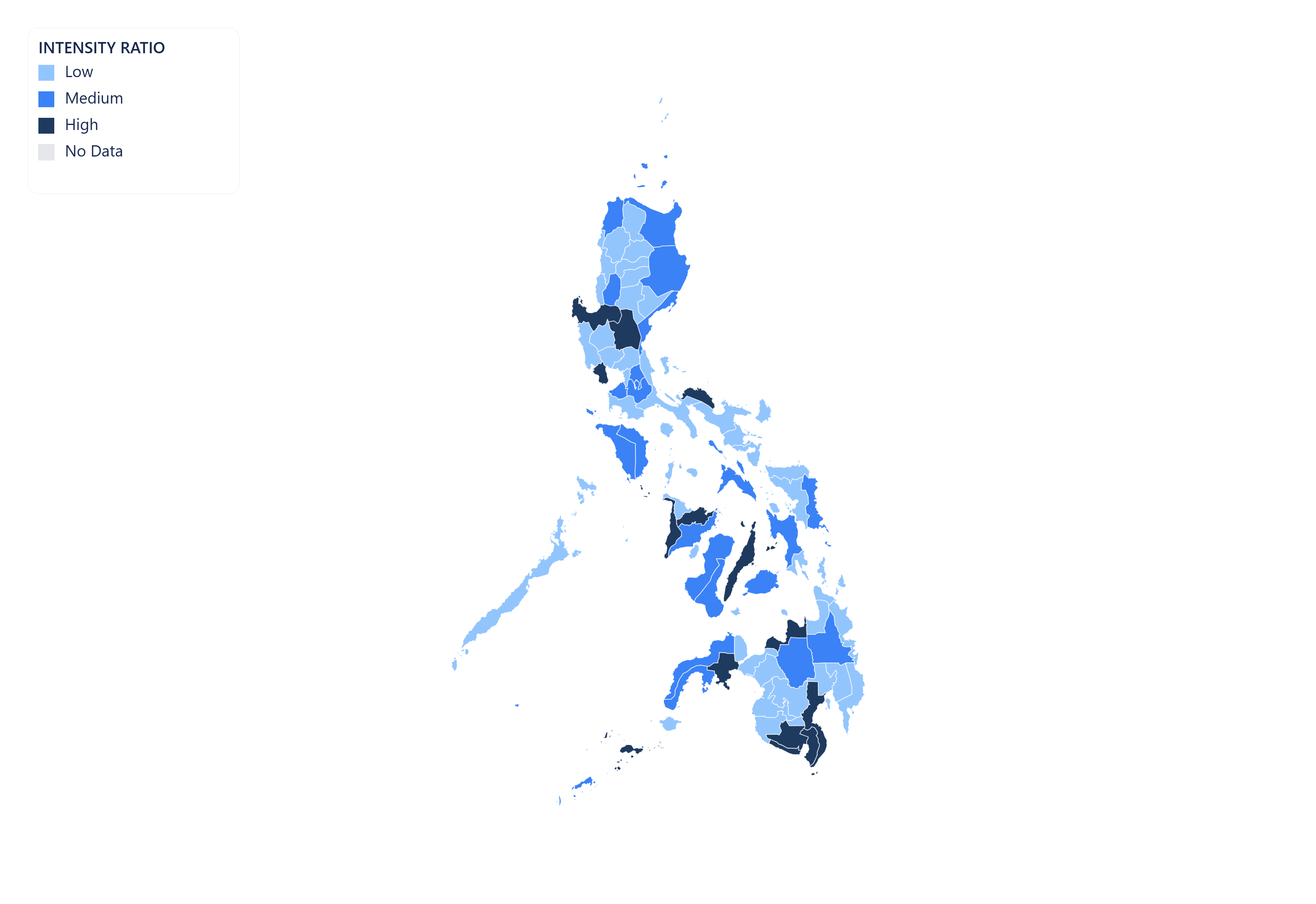
Vector SVG export
Export your Philippines map as a scalable vector graphic (SVG). Ideal for print publications, editorial illustrations, and web use — scales to any resolution without quality loss.

Animated GIF
Bring your Philippines data to life. Import historical time-series data and export a looping animated GIF showing how regional values changed over time.
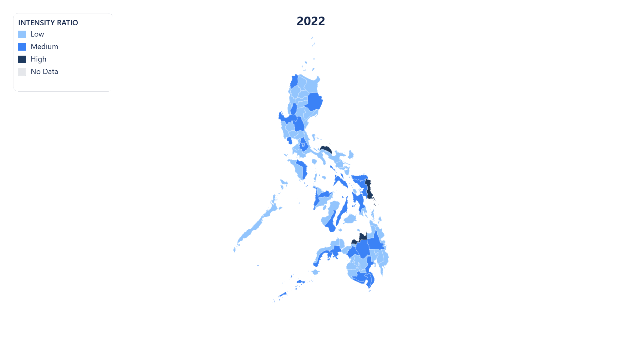
MP4 video export
Export your Philippines time-series map as an MP4 video. Perfect for presentations, reports, and social media posts where motion communicates change more clearly than static images.
Public share page
Share your Philippines choropleth map with a public link. Anyone with the URL can view the full interactive map — no account or login required.
Embeddable iframe
Embed your Philippines choropleth map anywhere with a single line of HTML. The iframe stays live — viewers always see the latest version of your map, no re-publishing needed.
AI-powered data import for Philippines maps
No spreadsheet? No problem. Regionify's AI Agent turns a plain-text description or raw pasted data into a ready-to-visualize dataset in seconds.
AI Generator
Generate Philippines data from a prompt
Describe the dataset you need in plain English — for example "GDP per capita of Philippines's 81 regions in 2023" or "election results by regions" — and the AI generates a plausible, structured dataset that maps directly onto Philippines's administrative boundaries. Edit any values in the table view before saving.
- ✓ Works for population, GDP, health, election, and custom metrics
- ✓ Supports time-series prompts for animated maps
- ✓ Output pre-matched to Philippines's 81 regions
AI Parser
Clean and import messy Philippines data
Paste raw text, a copied Wikipedia table, or an unstructured CSV with regional figures for Philippines. The AI parser normalises region names, strips noise, resolves mismatched spelling across Philippines's regions, and outputs a clean id–label–value table ready to visualise.
- ✓ Handles inconsistent or misspelled regions names
- ✓ Auto-detects time columns for historical data
- ✓ Streams results in real time as AI processes
AI Agent is available on the Chronographer plan.
Regions of Philippines
- Surigao del Sur
- Tarlac
- Tawi-Tawi
- Zambales
- Zamboanga del Norte
- Zamboanga Sibugay
- Abra
- Agusan del Norte
- Agusan del Sur
- Aklan
- Albay
- Antique
- Apayao
- Aurora
- Bataan
- Batanes
- Batangas
- Benguet
- Biliran
- Bohol
- Bukidnon
- Bulacan
- Cagayan
- Camarines Norte
- Camarines Sur
- Camiguin
- Capiz
- Catanduanes
- Cavite
- Cebu
- Compostela Valley
- Davao del Norte
- Davao del Sur
- Davao Oriental
- Dinagat Islands
- Eastern Samar
- Guimaras
- Ifugao
- Ilocos Norte
- Ilocos Sur
- Iloilo
- Isabela
- Kalinga
- La Union
- Laguna
- Lanao del Norte
- Lanao del Sur
- Leyte
- Maguindanao
- Marinduque
- Masbate
- Metropolitan Manila
- Misamis Occidental
- Misamis Oriental
- Mountain Province
- Negros Occidental
- Negros Oriental
- Cotabato
- Northern Samar
- Nueva Ecija
- Nueva Vizcaya
- Mindoro Occidental
- Mindoro Oriental
- Palawan
- Pampanga
- Pangasinan
- Quezon
- Quirino
- Rizal
- Romblon
- Samar
- Sarangani
- Siquijor
- Sorsogon
- South Cotabato
- Southern Leyte
- Sultan Kudarat
- Sulu
- Surigao del Norte
- Basilan
- Zamboanga del Sur
Build your own Philippines choropleth map — free
Upload any dataset, color Philippines's regions by any numeric metric, and export as PNG, SVG, GIF, or MP4. No design skills required — start in seconds, publish anywhere.