%20ammap.com%20%7C%20SVG%20map%20of%20United%20Arab%20Emirates%20-%20High%20--%3E%0A%3Csvg%20xmlns%3D%22http%3A%2F%2Fwww.w3.org%2F2000%2Fsvg%22%20xmlns%3Aamcharts%3D%22http%3A%2F%2Famcharts.com%2Fammap%22%20xmlns%3Axlink%3D%22http%3A%2F%2Fwww.w3.org%2F1999%2Fxlink%22%20version%3D%221.1%22%20viewBox%3D%220%200%20820%201250%22%20width%3D%22100%25%22%20height%3D%22100%25%22%20preserveAspectRatio%3D%22xMidYMid%20slice%22%3E%0A%09%3Cdefs%3E%0A%09%09%0A%0A%09%09%3Camcharts%3Aammap%20projection%3D%22mercator%22%20leftLongitude%3D%2251.530570%22%20topLatitude%3D%2226.079028%22%20rightLongitude%3D%2256.382213%22%20bottomLatitude%3D%2222.496694%22%3E%3C%2Famcharts%3Aammap%3E%0A%0A%09%09%3C!--%20All%20areas%20are%20listed%20in%20the%20line%20below.%20You%20can%20use%20this%20list%20in%20your%20script.%20--%3E%0A%09%09%3C!--%7Bid%3A%22AE-AJ%22%7D%2C%7Bid%3A%22AE-AZ%22%7D%2C%7Bid%3A%22AE-DU%22%7D%2C%7Bid%3A%22AE-FU%22%7D%2C%7Bid%3A%22AE-RK%22%7D%2C%7Bid%3A%22AE-SH%22%7D%2C%7Bid%3A%22AE-UQ%22%7D%2C%7Bid%3A%22OM-MU%22%7D%2C%7Bid%3A%22AE-NZ1%22%7D%2C%7Bid%3A%22AE-NZ2%22%7D--%3E%0A%0A%09%3C%2Fdefs%3E%0A%09%3Cg%3E%0A%09%09%3Cpath%20fill%3D%22white%22%20stroke%3D%22none%22%20id%3D%22AE-AJ%22%20title%3D%22'Ajm%C4%81n%22%20%20d%3D%22M609.22%2C118.01l2.09%2C-2.63l1.17%2C-2.2l0.44%2C0.29l0.09%2C0.53l0.83%2C-0.72l0.83%2C0.14l0.13%2C0.81l-0.44%2C1.63l-0.04%2C1.77l0.22%2C0.24l1.17%2C0.14l0.17%2C-0.19l-0.13%2C-0.29h-0.91l-0.04%2C-0.91l0.61%2C-0.53l-0.13%2C-0.24l-0.44%2C-0.05l-0.09%2C-0.86l0.52%2C-0.14l0.39%2C0.81l0.26%2C-0.19l-0.09%2C-0.67l-0.78%2C-0.96l1.48%2C-0.96l1.7%2C0.96l0.39%2C-0.1l0.7%2C0.24l0.43%2C-0.43l-0.04%2C-0.19H619l-0.26%2C-0.29l-0.74%2C0.14l-0.83%2C-0.34l-0.04%2C-0.77l0.7%2C-0.62l-0.57%2C-0.43l-0.39%2C0.58l-0.09%2C0.81l-1.74%2C0.72l-0.96%2C-0.14l-0.26%2C-0.48l2.22%2C-2.68v-0.53l0.7%2C-0.24l1.74%2C-2.83l-0.78%2C-0.77l0.3%2C-1.53l-0.17%2C1.39l0.13%2C0.14l0.48%2C-0.14l-0.04%2C0.38l0.35%2C0.19l0.48%2C-0.91l-0.83%2C-0.58l0.3%2C-0.29l0.83%2C0.24l0.52%2C-0.67l0.26%2C0.77l-0.39%2C0.1l0.04%2C0.58l0.48%2C0.29l0.83%2C2.37l0.93%2C0.91h1.04l0.78%2C-0.38l0.78%2C0.1l0.91%2C0.58l3.35%2C3.02l1.48%2C0.29l7%2C-0.24l1.22%2C0.29l3.44%2C1.48l0.17%2C0.43l-0.56%2C2.2l-1.61%2C4.41l-1.57%2C2.82l-0.74%2C0.81l-0.91%2C0.1l-1.65%2C-0.53l-1.48%2C-0.14l-2.13%2C0.1l-4.48%2C-0.38l-4.26%2C0.1l0%2C0l-0.96%2C-0.24l0%2C0l-1.22%2C-0.57l-3%2C-0.43l-2.13%2C-0.86l0%2C0l-2.44%2C-0.77l0%2C0L609.22%2C118.01zM696.18%2C137.7l-1.26%2C-1.05l-0.56%2C-0.91l-0.7%2C-1.87v-0.81l0.74%2C-1.77l0.78%2C-0.86l1.91%2C-1.29l3.13%2C1.63l0.35%2C0.48l0.48%2C1.96l-0.09%2C0.86l-1.57%2C1.72l-0.83%2C-0.05l-0.61%2C0.29L696.18%2C137.7z%22%2F%3E%0A%09%09%3Cpath%20fill%3D%22white%22%20stroke%3D%22none%22%20id%3D%22AE-AZ%22%20title%3D%22Ab%C5%AB%20Z%CC%A7aby%22%20%20d%3D%22M396.29%2C326.15l0.47%2C3.29l-2.35%2C0.47l-2.55%2C-2.13l-3.08%2C0.02l-1.64%2C-1.17l1.17%2C-2.58l3.29%2C0.24l2.82%2C0.47L396.29%2C326.15zM314.07%2C322.77l0.87%2C0.45l0.09%2C1.57l0.26%2C0.33l-0.17%2C0.33l-0.78%2C-0.05l-0.74%2C-0.43l-0.04%2C-1.76L314.07%2C322.77zM400.01%2C326.83h-1.44l-2.41%2C-4.45l2.41%2C0.84l1.92%2C1.44L400.01%2C326.83zM72.5%2C321.78l0.17%2C0.35l0.48%2C0.01l0.3%2C0.52l0.18%2C1.56l-0.14%2C1.75l0.26%2C-0.1l0.1%2C0.28l-0.36%2C0.72l-0.04%2C0.9v0.43l0.44%2C0.37l-0.18%2C0.62L72.45%2C329l-0.09%2C-0.44l-0.39%2C-0.27l-0.38%2C0.03l-0.01%2C0.24l-0.26%2C0.05l-0.3%2C-0.43l0.26%2C-0.66l0.74%2C-4.93l0.35%2C-0.09l-0.13%2C-0.71L72.5%2C321.78zM294.71%2C318.92l0.83%2C0.09l1.09%2C1.28l0.49%2C1.71l0.09%2C1.8l-1.1%2C0.14l-1.5%2C-0.14l-1.89%2C0.47l-2.13%2C-1.75l-0.91%2C-1.47l0.13%2C-0.57l1.24%2C-0.95L294.71%2C318.92zM404.7%2C323.59l-0.36%2C1.68l-2.64%2C-0.36l-3.54%2C-4.06l-2.11%2C-0.51l-0.12%2C-2.04h3.49l1.32%2C1.68l1.44%2C1.32l1.2%2C0.48L404.7%2C323.59zM75.64%2C313.48l1.26%2C0.54l0.39%2C1.23h0.3v0.43l-0.57%2C0.33l0.26%2C0.71l-0.3%2C0.57l0.36%2C0.09l0.04%2C0.71l-0.09%2C0.52l-0.26%2C0.05l-0.3%2C0.48l-0.26%2C0.81l-0.82%2C0.48l-0.27%2C0.8l-0.65%2C0.57l-0.44%2C-1l0.39%2C-0.1l0.04%2C0.47h0.26l0.17%2C-0.32l-0.22%2C-0.49l-1.44%2C0.29l-0.65%2C-0.1l-0.13%2C-0.28l0.35%2C-0.29l0.44%2C-1.33l0.17%2C-1.94L73.45%2C316l0.22%2C-1l0.83%2C-0.85l0.52%2C-0.09L75.64%2C313.48zM363.8%2C318.61l1.61%2C2.2l1.45%2C-0.27l1.82%2C0.68l5.68%2C0.57l2.61%2C0.79l3.75%2C4.54l-0.11%2C1.82l-2.16%2C4.43l-3.52%2C0.91l-2.16%2C0.79l-2.84%2C-0.79l-3.29%2C-0.46l-0.57%2C-1.36l-4.2%2C-0.23l-0.34%2C-2.5l-0.68%2C-1.14l-2.04%2C-1.02l-1.25%2C1.7l-0.57%2C2.84l0.23%2C2.84l-3.97%2C0.79l-6.13%2C-0.23l-3.52%2C-0.46l-1.82%2C-1.36l-2.5%2C-1.36l-3.18%2C-2.5h-2.04l-1.48%2C1.36l-2.38%2C0.23l-2.04%2C-0.23l-1.02%2C-1.14l-0.91%2C-1.93l2.38%2C-2.61l4.2%2C-1.93l3.36%2C-0.11l2.43%2C-1.14l1.1%2C-2.26l4.58%2C-2.74l1.72%2C1.66l6.8%2C-3.14h2.5l1.73%2C-2.03l2.24%2C-1.04l0.45%2C-1.93l2.73%2C-0.11l1.93%2C1.14l-1.14%2C1.02l-1.36%2C0.45l-0.23%2C2.38L363.8%2C318.61zM260.57%2C303.96l1.44%2C1.15l0.04%2C0.71l0.26%2C0.38l1.48%2C0.57l0.21%2C1.53l-0.17%2C0.4l-2.52%2C0.24l-0.61%2C-0.75l-0.13%2C-0.52l-1.09%2C-1.04l-0.17%2C-1.66L260.57%2C303.96zM282.02%2C303.1l2%2C0.9l1.48%2C1.67l-0.74%2C0.33l-1.09%2C-0.04l-0.4%2C-0.29l-0.6%2C0.1l-1%2C2.14l-0.13%2C1.42l0.44%2C0.95l-0.09%2C1.14l0.48%2C1.57l-1.52%2C-0.57l-1.09%2C-2.47l-0.83%2C-0.19l-0.65%2C-0.57l-2.09%2C-0.19l-1.09%2C-1.09l-0.61%2C-0.23l-1.09%2C0.14l-0.61%2C0.47l-0.26%2C0.38l-0.6%2C2.8l-0.4%2C0.19l-2.83%2C-0.24l-0.43%2C-0.95l-0.7%2C-0.81l-0.83%2C-0.14l-0.73%2C-0.82l-0.92%2C0.01l-0.04%2C-0.71l0.43%2C-1.01l0.44%2C0.3l0.96%2C0.05l1.36%2C-0.58l1.17%2C-0.03l0.4%2C-0.48h0.64l0.48%2C0.38l0.3%2C-0.33l-0.39%2C-0.33l0.44%2C-0.29l4.74%2C-0.94l2.31%2C-0.85l2.57%2C-0.09l0.52%2C-0.57L282.02%2C303.1zM326.32%2C306.43l-2.11%2C1.17l-2.11%2C-0.23l-0.94%2C-1.88l0.94%2C-1.64l2.35%2C-0.94L326.32%2C306.43zM244.19%2C298.93h0.25l0.26%2C0.38l1.04%2C2.37l-0.04%2C0.66l0.26%2C0.47l0.17%2C0.05l0.39%2C-0.62l0.29%2C0.09l-0.03%2C0.62l-0.57%2C0.19l0.48%2C1.09l-0.39%2C-0.19l-0.27%2C-0.66l-2.52%2C-0.43l-1.26%2C-0.76l-0.35%2C-0.52l0.22%2C-1.66L244.19%2C298.93zM431.27%2C312.28l-1.68%2C1.32l-5.53%2C-1.2l-2.29%2C2.41l-1.32%2C-0.84l-2.16%2C-2.53l-0.48%2C-2.04l-1.32%2C-2.16l-4.09%2C-0.6l-0.72%2C-1.68l0.48%2C-3.25l4.93%2C-1.68l2.04%2C-3.01l3.97%2C3.01l0.12%2C1.92l0.96%2C2.16l1.68%2C2.91l4.09%2C2.38L431.27%2C312.28zM167.72%2C295.03l0.17%2C0.63l2%2C-0.29l0.52%2C0.43l1.69%2C0.32l1.22%2C0.86l0.91%2C1.29l0.39%2C1.52l0.43%2C0.09l0.09%2C3.8l-0.04%2C0.47l-0.26%2C0.14l0.16%2C-3.66l-0.21%2C-0.62l-0.13%2C1.47l-0.48%2C0.62l0.26%2C1.38l-0.57%2C2.38l0.23%2C0.33l-0.7%2C0.33l-0.48%2C1.33h-0.44l0.09%2C-0.33l-0.56%2C0.24l-1.09%2C3.08h-0.7l-0.87%2C-0.57l0.74%2C0.29l0.4%2C-0.14l0.42%2C-1.05l-0.26%2C-0.33l-0.48%2C0.05l-1.44%2C1.19l-0.09%2C0.33l0.56%2C0.22l-0.65%2C0.01l0.13%2C0.43l-0.48%2C0.47l-0.26%2C-0.1l-0.83%2C1l-0.13%2C0.57l0.09%2C0.38l0.3%2C0.05l0.22%2C-1.14l0.78%2C-0.28l0.32%2C1.04l-0.1%2C0.52l-2.35%2C1.04l-0.96%2C-0.57l-0.17%2C-0.9l0.74%2C-1.95l0.78%2C0.9l0.22%2C-0.05l-0.91%2C-1.9l-2.79%2C-2.42l-0.78%2C-1.47l-0.83%2C-2.66v-1.9l0.26%2C-1.22l-0.17%2C-0.11l1.13%2C-2.61l1.26%2C-1.66l1%2C-0.47l0.39%2C0.05l0.26%2C0.38l0.74%2C-0.14l0.92%2C-0.58l-0.27%2C-0.52h0.66V295.03zM436.32%2C300.5l-0.6%2C1.8l-1.68%2C0.48l-2.04%2C-0.36l-0.5%2C-2.61l1.46%2C1.29l1.32%2C-0.12l1.08%2C-1.92l-2.55%2C-3.71l-2.98%2C-2.3V291h1.92l2.17%2C1.68l3.49%2C3.73l0.24%2C1.68L436.32%2C300.5zM426.1%2C297.86h-1.92l-1.68%2C-2.04l-5.05%2C-1.8l-3.73%2C-0.6l-1.08%2C-0.84l6.37%2C-0.36l2.04%2C-1.8l0.84%2C-2.04l2.4%2C-0.72l0.84%2C2.77l-1.25%2C1.28l-0.2%2C1.96l1.94%2C1.56L426.1%2C297.86zM2.52%2C284.85l0.44%2C0.6l1.96%2C0.29h0.39l0.09%2C-0.2l0.82%2C0.09l0.18%2C0.58l-0.44%2C0.19L6%2C287.11l0.17%2C-0.48l0.57%2C0.1l-0.96%2C0.85l-0.04%2C1H5.35l0.18%2C-2.34l-0.75%2C-0.13l-1.09%2C0.43l-0.26%2C0.8l0.56%2C1.1l1.13%2C0.43l-0.04%2C0.19l-1.39%2C-0.43l-0.74%2C-1.14l-0.87%2C0.09l0.22%2C1.05l-0.35%2C-0.95L1%2C288.01l-0.09%2C0.28l0.26%2C0.14l-0.26%2C0.34l-0.44%2C-0.15l-0.04%2C-0.38L0%2C288.01l0.26%2C-0.86l0.26%2C-0.47l0.78%2C-0.48l0.91%2C-1.42L2.52%2C284.85zM434.94%2C281.03l0.22%2C0.19l-0.13%2C1.24h-0.53l-0.43%2C-1.24L434.94%2C281.03zM437.76%2C281.03l0.36%2C0.33l-0.01%2C0.38l1.7%2C0.19l3.78%2C3.23l1.04%2C0.52l2%2C0.56l0.3%2C0.3h0.52l3.74%2C1.38l-0.26%2C0.71l-2.7%2C1l-0.96%2C-0.48l-0.87%2C0.1l-1.47%2C-0.81l-1.35%2C-0.42l-0.57%2C-0.52l-2.22%2C-0.57l-0.35%2C-0.62l-0.65%2C-0.05l-0.57%2C0.38l-1.09%2C-0.29l-0.48%2C-1.28l-0.39%2C-2.85l-0.04%2C-0.9L437.76%2C281.03zM435.94%2C281.06l0.4%2C1.53l-0.14%2C0.29l-0.91%2C0.05l0.22%2C-1.76L435.94%2C281.06zM465.51%2C278.4l0.82%2C0.76l4.14%2C0.91l0.44%2C0.53l-0.01%2C0.66l0.39%2C0.52l-0.09%2C0.9l-0.7%2C0.38l-0.48%2C-0.04l0.05%2C-0.53l-0.64%2C-0.43l-0.23%2C0.09v0.29l-1.83%2C0.52l-0.74%2C1.33l-2.3%2C0.29l0.04%2C-0.91l-2.57%2C-0.23l-0.57%2C-0.62l-0.22%2C-1.19l0.57%2C-0.85l0.39%2C-1.33l0.53%2C-0.24l0.08%2C0.57l-0.69%2C1.48l1.04%2C0.43l0.61%2C-0.14l0.09%2C-0.48l0.3%2C-0.1l0.3%2C0.71l0.96%2C0.01l0.09%2C-0.34l-0.35%2C-0.29l-0.43%2C-2L465.51%2C278.4zM433.56%2C275.8l-1.1%2C0.81l-0.13%2C1.9l0.43%2C0.43l0.04%2C0.67l0.96%2C1.14l-0.96%2C0.19l-0.57%2C-1.14l0.31%2C1.32l-0.7%2C0.2l-0.26%2C-0.52l0.13%2C-1.47l-0.39%2C-0.19l0.26%2C-0.48l0.48%2C-0.24l0.17%2C-1.95L433.56%2C275.8zM464.03%2C275.37l0.39%2C0.34l2.13%2C0.19l1%2C0.67l2.61%2C0.51l3.87%2C1.48l1.04%2C1.1l0.52%2C1.53l-0.57%2C0.42l-1.52%2C0.33l-0.78%2C0.43h-0.78l-0.25%2C-1.27l-1.18%2C-1.1l-3.09%2C-0.86l-0.87%2C-0.82l-2.6%2C-1.13l-0.49%2C-0.48l-0.26%2C-0.95l0.26%2C-0.33L464.03%2C275.37zM460.86%2C274.57l0.96%2C0.18l0.48%2C0.34l0.57%2C0.95l-0.04%2C0.33l-0.52%2C0.09l-1.61%2C-0.57L460.86%2C274.57zM454.77%2C272.63l1.48%2C0.37l1.87%2C0.95l1.87%2C0.48l0.57%2C2.14l0.52%2C0.24l0.44%2C0.57l-1.92%2C1.47l0.48%2C1.33l-0.39%2C-0.19l-1.57%2C-1.95l-0.44%2C-0.05l-1.09%2C-0.91l-1.35%2C0.06l-0.78%2C-1.47l-0.65%2C-0.52l0.35%2C-0.96l2.44%2C0.81l0.26%2C0.43l0.22%2C-0.57l-2.39%2C-0.96l0.04%2C-0.86l-0.21%2C-0.32L454.77%2C272.63zM449.81%2C269.76l0.43%2C0.01l1.57%2C1.09l-0.17%2C0.24l-0.26%2C-0.05l-0.09%2C1.19h0.52l0.61%2C1.52l0.35%2C0.19l0.39%2C0.86l-0.81%2C1.47l-0.53%2C0.33h-0.61l-1.17%2C-1.47l-0.74%2C-0.53l-0.57%2C-0.09l-0.09%2C-0.33l-0.57%2C-0.38l0.38%2C-0.67l-0.34%2C-0.81l0.43%2C-0.56v-0.48l-0.26%2C-0.19l0.22%2C-0.9l0.44%2C-0.1l0.48%2C0.67l0.44%2C0.09l-0.22%2C-0.66L449.81%2C269.76zM473.86%2C265.95l0.87%2C0.58l1.04%2C0.1l0.17%2C0.33l-0.13%2C0.52l-0.22%2C0.14l-1.87%2C-0.38l-0.26%2C-0.52l0.13%2C-0.77H473.86zM121.91%2C264.3l0.17%2C0.38l1.79%2C0.62v0.52l0.3%2C0.29l1.13%2C0.14l0.35%2C0.24l0.69%2C3.71l0.61%2C1.52v1.47l-1.09%2C0.19l-0.48%2C-0.29l-0.3%2C0.95l0.56%2C0.51l-0.18%2C0.11l-0.61%2C-0.29l-1.26%2C1.95l0.44%2C0.43l-0.65%2C0.05l-0.48%2C3.23l-0.26%2C4.75l0.13%2C0.95l-1.43%2C0.24l-0.38%2C-0.24l0.04%2C-0.9l0.7%2C0.05v-2.1l0.4%2C-2.66v-2.76l-0.36%2C-1.04l-0.39%2C-0.24v-0.71l-0.35%2C-0.05l-0.22%2C0.48l-0.26%2C-0.09l0.21%2C-0.67l-2.57%2C-1.52l-0.78%2C-2.19l-0.13%2C-0.95l0.87%2C-1.19l1.3%2C-2.52l1.04%2C-0.67l0.65%2C-1.62L121.91%2C264.3zM476.69%2C262.82l0.39%2C0.38l0.25%2C1.04l-0.52%2C0.3l-0.17%2C0.76l-0.78%2C0.29l-0.43%2C-0.38l-0.3%2C-1.14l0.78%2C-1.09L476.69%2C262.82zM467.04%2C262.23l1.17%2C0.83l1.14%2C0.19l0.73%2C0.91l0.65%2C-0.05l1.04%2C0.53l0.49%2C0.66l0.08%2C1.81l-2.04%2C-0.38l-1.22%2C1.05l-0.35%2C-0.24l-0.91%2C0.05l-2.13%2C-2.19l-0.17%2C-0.76l-0.57%2C-0.05l-0.43%2C-0.71l2.35%2C-1L467.04%2C262.23zM467.51%2C258.42l4.87%2C1.12l0.7%2C-0.32l0.78%2C0.99l0.61%2C-0.24l0.52%2C0.24l1.04%2C0.05l2.09%2C-0.33l1.04%2C0.47l-0.61%2C0.14l-0.26%2C1.9l-1.04%2C-1.84l-0.62%2C-0.05l-0.47%2C0.24l-0.09%2C0.24l2.04%2C1.76l-0.22%2C0.29l-0.71%2C-0.39l-1.34%2C-0.04l-0.78%2C-1l-1.82%2C-0.81l-1.66%2C0.29l-0.43%2C0.71h-0.87l-0.65%2C-0.39l-0.61%2C-0.04l-0.52%2C-0.57l0.04%2C-0.62l-1%2C-0.43l0.22%2C-0.67l-0.18%2C-0.38l-0.48%2C-0.09l0.04%2C-0.24L467.51%2C258.42zM460.76%2C257.08l0.53%2C0.07l0.09%2C0.2l-0.78%2C0.62l-0.91%2C1.62l-0.13%2C0.76l-1.09%2C1.24l-0.52%2C1.52l0.04%2C0.86l0.96%2C2.76l0.52%2C0.81l0.26%2C1.05l0.96%2C1.52l0.35%2C1.57l-0.52%2C1.24l-0.35%2C0.05l-0.43%2C-1.09l0.12%2C-0.71l-0.21%2C-0.38l-0.3%2C0.38l-0.57%2C0.05l-4.83%2C-2.28l-2.91%2C-0.62l-2.44%2C-2.28l-0.26%2C-0.71l0.22%2C-0.19l0.74%2C0.19l2.83%2C-0.44l2.22%2C-1.02l2.52%2C-2.24L460.76%2C257.08zM30.14%2C254.55l0.61%2C0.43l-0.17%2C0.43l0.26%2C0.52l1.13%2C0.28l0.09%2C0.33l-0.43%2C0.14v0.84l-1.61%2C2.34l-0.08%2C0.48l-0.48%2C0.09l-0.52%2C-0.57l-0.26%2C-0.72l-0.87%2C-0.76L27.77%2C258l0.74%2C-1.27l0.04%2C-1.2l0.52%2C-0.57l0.7%2C-0.05L30.14%2C254.55zM474.91%2C251.47l0.65%2C0.03l1.04%2C0.76l0.04%2C1.43l0.4%2C1.13l-1.01%2C-0.32l-1.13%2C0.05l-0.09%2C-0.43l0.52%2C-1l-1%2C-0.81l-0.22%2C-0.43l0.43%2C-0.43L474.91%2C251.47zM472.56%2C248.52l0.52%2C0.22l0.18%2C0.62l-0.23%2C0.76l0.04%2C1.29l1.13%2C1.85l-0.48%2C0.76h-0.35l-1.48%2C-1.24l-1.12%2C0.23l-1.75%2C0.96l-2.09%2C-0.9l-0.65%2C0.28h-1.13l-0.04%2C-0.52l0.52%2C-0.38l-0.52%2C-0.24l0.65%2C-0.37l0.22%2C0.28l0.69%2C-0.1l0.23%2C0.62l1.52%2C-0.76l0.83%2C-0.81l0.9%2C-1.43l-0.17%2C-0.57l0.13%2C-0.24l1.91%2C-0.09L472.56%2C248.52zM483.17%2C247.47l0.7%2C0.56l0.91%2C0.19v0.37l0.69%2C0.58l0.09%2C0.86h-0.53l-0.03%2C-0.52l-0.66%2C-0.09l-0.61%2C0.04l-0.35%2C0.34l-0.04%2C-1.14l-0.44%2C-0.76L483.17%2C247.47zM161.1%2C220.24l1.09%2C0.41l0.64%2C1.38v0.81l-0.56%2C0.9l-0.04%2C1l-0.39%2C0.19l-1.04%2C-0.52l-0.3%2C-0.57l-0.01%2C-0.62l-0.73%2C-0.52l-0.35%2C-0.57l-0.04%2C-1l0.39%2C-0.71L161.1%2C220.24zM240.69%2C203.49l1.09%2C0.28l0.74%2C0.48l0.74%2C1.71l0.56%2C0.1l-0.39%2C0.67l1.09%2C1.33l0.04%2C0.24l-0.26%2C0.1l-1.09%2C-1.38l-0.39%2C0.86l0.09%2C2.05l-0.56%2C-0.05l-0.48%2C-0.38l0.1%2C-0.67l-0.75%2C-0.15l-1.12%2C-1.48l-0.78%2C-0.62l-0.31%2C-0.71l-0.04%2C-0.43l0.83%2C-1.81L240.69%2C203.49zM206.42%2C195.59l0.47%2C0.46l0.27%2C1.24l0.83%2C0.67v1.05l-0.09%2C0.19l-0.22%2C-0.19l-0.39%2C0.52l-0.17%2C-0.1v-0.67l-0.48%2C-0.38l-0.17%2C-0.81h-0.39l-1.35%2C-0.91v-0.33l0.48%2C-0.38l0.78%2C-0.38L206.42%2C195.59zM135.52%2C192l0.35%2C0.52l-0.04%2C0.48l1.35%2C1.29v0.57l-0.43%2C0.14l-0.13%2C0.53l-0.66%2C-0.34l-0.83%2C-1.1l-0.22%2C-1.67L135.52%2C192zM445.73%2C314.69l0.82%2C-0.52l0.13%2C-0.52l-0.79%2C-0.7l-0.52%2C-0.91l0.39%2C-0.05l-0.09%2C0.28l0.48%2C0.43h0.74l2.13%2C-0.95l0.35%2C-0.43l1%2C-0.19l0.61%2C-0.47l-0.48%2C-0.81l0.26%2C-0.33l0.48%2C0.33l0.13%2C0.53l1.04%2C-0.67l0.39%2C-0.42l-0.04%2C-0.67l1.87%2C-1l0.52%2C-0.67l0.26%2C-0.48l-0.21%2C-0.18l-1%2C1.05l-0.61%2C-0.05l0.83%2C-0.52l0.83%2C-1.58l0.43%2C-0.13l0.3%2C-1.33l0.83%2C-0.87l0.96%2C0.96l0.78%2C0.19l9.05%2C-0.47h0.22l0.22%2C0.47h0.87l-0.13%2C-0.61l-0.61%2C-0.06l-9.92%2C0.43l-0.83%2C-0.52l-0.31%2C-0.85l0.61%2C-2.28l0.91%2C0.47l-0.65%2C-1.23l0.04%2C-0.71l0.96%2C-3.62l0.57%2C0.06l0.13%2C-0.29l-0.13%2C-2.33l0.17%2C-0.33l0.79%2C-0.29l2.82%2C0.19l1.3%2C-0.33l0.48%2C0.19l1.39%2C-0.29l0.39%2C0.19l0.74%2C-0.06l-0.22%2C-0.7l0.09%2C-0.56l-2.3%2C-0.05l-1%2C0.28h-1.22l-0.35%2C0.9l-0.66%2C-0.14l-0.47%2C-0.33l-0.65%2C-1l0.31%2C-0.19l0.96%2C0.33l1.43%2C0.05l-0.17%2C-0.24l-1.52%2C-0.11l-0.26%2C-0.23l1.13%2C-0.85l0.52%2C-0.71h0.39l-0.26%2C-1.57l-0.57%2C-0.85l-0.13%2C0.43l0.17%2C0.76l-0.39%2C0.43l-0.13%2C1.14l-0.61%2C0.1l-0.74%2C-0.2l0.22%2C0.58l-0.34%2C0.47l-0.43%2C-0.62l-0.35%2C0.05l-0.3%2C0.81l-0.83%2C-0.19l-1.13%2C-0.66l0.3%2C-0.81l0.3%2C-0.14l1.57%2C0.61l0.26%2C-0.62l-5.83%2C-1.9l-1.95%2C-0.33l0.04%2C0.29l5.13%2C1.66l-0.38%2C1.15l-0.27%2C0.04l-4.64%2C-1.75l-0.49%2C-0.86l-0.96%2C-0.38l-0.26%2C-0.33l-0.83%2C0.14l-0.52%2C-0.47l-0.21%2C-0.53l-2.45%2C-0.85l-0.26%2C0.1l2.71%2C1.09l-0.23%2C0.76l-0.74%2C-0.14l-0.91%2C-0.66l-0.91%2C-0.19l-1.26%2C-0.81l-1.05%2C0.05l-2.35%2C-2.28l-1.48%2C-1.09l0.09%2C-0.28h0.78l-0.22%2C-0.37l-0.99%2C-0.06l-0.53%2C0.81l-0.78%2C-0.05l-0.26%2C-0.33l1.04%2C-0.24l-0.04%2C-0.24l-1.04%2C0.05l-0.39%2C-0.19v-0.48l-1.04%2C-0.05l-0.13%2C0.43l-0.78%2C-0.29l-0.43%2C0.95l-1.83%2C-1.14l0.13%2C-1.14l1.26%2C-0.24l0.39%2C1.28l5.26%2C-3.05l0.78%2C-1.89l2.96%2C-2.47l1.17%2C-1.65l-1.13%2C0.47l-1.48%2C-1.48l0.52%2C-1.9l0.43%2C0.28l1.04%2C-0.71l0.3%2C-0.33l-0.17%2C-0.52l0.35%2C-0.38l-1.61%2C0.29l-0.3%2C0.33l0.17%2C-0.43l2.35%2C-0.67l0.26%2C0.43l0.44%2C-0.1l0.48%2C0.48l-0.96%2C1.71l1.74%2C1.76l1.09%2C-0.85l-0.57%2C0.85l-0.92%2C0.42l-0.43%2C1l-0.74%2C0.9l0.96%2C2.23l3.26%2C2.9l0.7%2C0.43l1.17%2C-0.01l-0.22%2C0.29l-0.78%2C0.1l0.43%2C0.52h0.65l0.09%2C-0.43l0.48%2C0.05l1.17%2C0.86l0.61%2C-0.1l0.65%2C1.05l0.96%2C0.67l-0.3%2C0.57l0.09%2C0.38l-0.3%2C0.24l1.04%2C0.57l1%2C-0.29l1.48%2C0.18l0.65%2C1.77l1.78%2C1.04l0.65%2C0.76l0.97%2C-0.67l4.95%2C0.29l1.85%2C-1l0.76%2C-0.24l0.48%2C0.19l1.7%2C-0.48l8.52%2C-2.71l0.48%2C-0.57l0.18%2C-0.86l-0.22%2C-0.37h-0.31l-0.7%2C0.95l-0.83%2C0.24l-1.26%2C-0.33l-0.39%2C0.62l-0.57%2C0.28l-1.74%2C0.24l-0.43%2C-0.25l-0.22%2C-1.46l2.09%2C-2.14l0.48%2C-1.19l-0.39%2C-0.76l-5.09%2C-0.19l-1.09%2C-0.33l-0.74%2C0.09l-0.91%2C0.58l-1.18%2C-0.14l-1%2C-0.48h-1.56l-0.96%2C-0.76l-1.61%2C-0.14l-0.87%2C0.29l-0.61%2C-0.34l-0.7%2C0.06l-0.96%2C-0.52l0.22%2C-0.9l0.75%2C-0.24l0.34%2C0.34l0.45%2C-0.67l-1.05%2C-0.56l-0.96%2C-2.39l-0.39%2C-0.29l0.26%2C-0.48l0.3%2C0.43l0.36%2C-0.23l-0.75%2C-1.33l-1.18%2C-1.33l-0.43%2C-1.57l0.04%2C-0.9l0.35%2C-0.71l0.43%2C-0.05l0.17%2C-0.57l0.39%2C-0.25l0.04%2C-0.9l0.91%2C0.52l0.05%2C-0.38l-0.57%2C-0.33l-0.13%2C-0.33h2.57l-0.35%2C1.47l0.48%2C1.28l1.52%2C2.42l2.7%2C2.76l1.52%2C0.52l0.87%2C-0.1l2.91%2C1.24l2.65%2C0.71l2.65%2C0.33l1.56%2C-0.75l0.83%2C-0.76l0.52%2C-0.86l0.49%2C-0.3l0.69%2C-1.37l0.13%2C-1.9l0.43%2C-1.01l-0.12%2C-0.47l0.69%2C-0.32l0.26%2C-0.48l-0.04%2C-0.47h0.56l0.13%2C0.39l0.21%2C-0.28l-0.04%2C-0.39l-1.7%2C-1.19l0.39%2C-0.23l1.4%2C1.22l0.25%2C-0.52l0.43%2C0.14l0.3%2C-0.14l0.61%2C-1.71l-0.52%2C-0.52l1.35%2C-1.87l0.35%2C-1.61l-0.3%2C-0.57l-0.48%2C-0.29l-0.09%2C-0.57l-1.13%2C-0.1l-1.92%2C0.57l-0.26%2C0.24l0.35%2C0.62l-0.26%2C0.19l-1.65%2C0.43l-0.66%2C0.47l-1.17%2C-0.09l-0.44%2C0.57l-0.35%2C-0.14l-0.61%2C-1.28l-0.71%2C-0.43l-0.47%2C-0.71l0.3%2C-1.38l-0.3%2C-0.33l0.04%2C-1.05h-0.44l-0.48%2C-0.81l-0.17%2C-0.95l0.35%2C-0.52l0.6%2C-0.23l0.36%2C-0.77l0.52%2C-0.14l0.05%2C-0.38l-0.78%2C-0.1l-0.35%2C-0.95l0.31%2C-0.99l0.52%2C-1.06l0.83%2C-0.05l0.74%2C0.52l-0.04%2C0.33l0.61%2C-0.05l0.17%2C-0.33l0.87%2C-0.1h0.7l0.7%2C0.33l0.13%2C0.33l-0.43%2C0.29l0.57%2C0.39l0.09%2C0.46l-0.35%2C0.24l0.26%2C1.57l0.58%2C0.67l-0.1%2C0.85l-0.17%2C0.19l-1.09%2C-0.05l-1.04%2C0.29l-0.13%2C0.62l0.26%2C0.38l-0.17%2C1.19l0.22%2C0.86l0.52%2C0.57l0.3%2C0.86l0.57%2C0.24h0.17l-1.17%2C-2.14l0.65%2C-1.33h0.48l1.4%2C-0.81h1.95l0.39%2C0.29l3.13%2C-2.95l-0.78%2C-0.67h-0.83l0.35%2C-0.33l-0.04%2C-0.33l-0.48%2C-0.05l-0.3%2C-0.52l0.48%2C-0.48l0.89%2C-0.2l1.02%2C0.29l1.48%2C-0.43l-0.47%2C-0.29l-0.57%2C-1.04l1.78%2C0.24l0.3%2C-0.38l-0.65%2C-0.09l-0.3%2C-0.42l-1%2C-0.15l-0.13%2C-0.38l0.26%2C-0.05l0.09%2C0.19l0.3%2C-0.24l-0.29%2C-0.77l-0.4%2C-0.14l-0.43%2C0.68l-0.35%2C1.9l-1.65%2C-0.28l-0.13%2C-0.24l0.3%2C-1.05l-0.21%2C-0.57l0.65%2C0.38l0.18%2C-0.48l-0.35%2C-0.23h-1.13l0.7%2C-0.76l0.61%2C-0.19h0.52l-0.22%2C0.71l0.22%2C0.29l0.78%2C-0.19l0.61%2C-1.3l0.87%2C-0.61l-0.18%2C-1.48l-1.12%2C0.19l-0.35%2C-0.19l0.04%2C-0.9l0.61%2C-0.29l0.04%2C-0.67l0.44%2C0.05l0.13%2C0.57l0.48%2C-0.1l-0.39%2C-2.28l0.12%2C-0.43l-0.69%2C-0.62l-0.56%2C0.39l-0.69%2C-0.39l-1.79%2C0.05l-0.78%2C-0.76l0.09%2C-0.33l0.61%2C-0.24l0.25%2C-0.44l0.35%2C0.05l0.35%2C0.52h0.22l2.26%2C-1.52v-0.33h-0.43l-1.78%2C1.43l0.13%2C-1.38l0.91%2C-0.87l1.09%2C-0.33v-0.19l-1.1%2C0.28l-1.38%2C0.86l-0.09%2C-0.19l1.39%2C-0.76l0.61%2C-0.76l0.82%2C-0.53v-0.43l0.3%2C-0.33l1.35%2C-0.62l0.39%2C-0.81l0.91%2C-0.71l1.7%2C-2.05l1.91%2C-3.43l0.65%2C-1.95l0.74%2C0.19l0.96%2C0.86l1.65%2C0.86l1.43%2C0.34l0.74%2C0.51l0.39%2C-0.09l0.04%2C-0.81l-0.56%2C-0.29l-1.09%2C0.05l-2.61%2C-1.53l-0.48%2C-0.57l0.44%2C-1.62l0.78%2C-1.14l1.87%2C-1.29l0.27%2C0.06l-0.09%2C0.52l-0.61%2C1l1.87%2C-1.19l0.83%2C0.29l1.83%2C0.01v2.61l1.35%2C1.81l0.57%2C0.34l0.87%2C1.05l0.22%2C-0.33l-2.27%2C-2.34l0.39%2C-0.05l0.35%2C-0.57l-1%2C-0.43l-0.26%2C-3.43l0.26%2C-0.72l-0.09%2C-1.04h0.18l0.39%2C1.48l0.26%2C0.29l0.74%2C0.05l3.13%2C-1.33l0.14%2C-0.33l-0.27%2C-0.67l0.48%2C0.76l1.3%2C-0.19l0.09%2C-1.19l0.22%2C-0.15l-0.13%2C-0.95l0.25%2C1l-0.21%2C0.15l0.04%2C0.95l3%2C-1.86l-0.48%2C-0.81l0.48%2C-0.24l-0.13%2C0.24l0.27%2C0.24l0.39%2C-0.04l0.48%2C-1.1l0.13%2C0.33l0.39%2C0.1l1.65%2C-1.43l0.04%2C-0.29l-1.08%2C-0.62l0.22%2C-0.48l0.78%2C-0.48l-0.22%2C0.76l1.13%2C0.86l0.74%2C-1.48l-0.7%2C-0.43l0.26%2C-0.53l0.22%2C0.13l-0.26%2C0.25l0.78%2C0.86l0.57%2C-0.24l-0.91%2C-1.43l0.35%2C0.05l0.22%2C0.67l0.35%2C-0.05l3.44%2C-1.96l0.92%2C-1.15l1.26%2C0.33l1.82%2C-1.62l0.27%2C-0.76l0.52%2C-0.05l2.22%2C-1.72l5.26%2C-4.87l0.87%2C-0.33l1.17%2C0.05l4.91%2C-2.48l0.21%2C0.53l0%2C0l1.03%2C3.07l0%2C0l19.18%2C55.46l2.83%2C6.99l11.13%2C0.38l10.05%2C-0.14l4.14%2C-1.48l0%2C0l0.34%2C-0.06l0%2C0l1.38%2C-0.23l10.05%2C0.57l6.62%2C-0.32l4.17%2C-0.79l3.32%2C-1.23l0%2C0l2.21%2C-1.17l0%2C0l1.91%2C-1.38l4.04%2C-4.47l4.22%2C-0.43l1.35%2C-0.67l5.31%2C-3.81l1.91%2C-0.76l0%2C0l3.87%2C-0.33l0%2C0l1.7%2C-0.52l1.83%2C-1.05l1.17%2C-1.47l0%2C0l2.91%2C0.62l2.74%2C1.29l2.35%2C0.81l5.48%2C1.14l2.61%2C-0.1l4.65%2C-1.05l2.94%2C-1.91l0%2C0l3.04%2C7.35l0.26%2C0.79L675%2C246.1l-0.39%2C0.88l-0.89%2C1.03l-3.2%2C2.83l-0.09%2C2.17l0.5%2C2.92l-0.25%2C1.39l-4.2%2C2.57l-0.35%2C2.53l0.72%2C2.59l0.06%2C1.96l1%2C2.53l0.16%2C8.82l-0.41%2C2.57l0.06%2C1.37l0.29%2C1.38l1.01%2C0.54l2.93%2C2.56l1.63%2C2.19l0.51%2C3.83l0.09%2C4.31l-0.25%2C3.22l-3.34%2C4.71l-3.56%2C5.66l-1.75%2C5.77l-0.03%2C0.94l0.54%2C0.72l0.89%2C0.5l1.31%2C0.33l2.33%2C-0.02l2.43%2C-0.37l2.39%2C1.12l2.32%2C1.43l1.09%2C0.04l1.13%2C-0.24l1.6%2C-1.09l4.83%2C-2.43l5.82%2C-0.32l1.47%2C1.75l-0.21%2C1.67l0.53%2C1.75l0.51%2C0.78l1.09%2C0.96l1%2C7.81l3.07%2C3.85l3.62%2C6.53l0.5%2C2.17l-0.87%2C0.67l-1.57%2C0.62l-16.85%2C4.33l-10.03%2C5.22l-1.57%2C0.59l-1.52%2C-0.2l-3.66%2C-2.66l-0.85%2C-1.32l-1.62%2C-0.21l-4.73%2C2.01l-1.88%2C0.31l-1.56%2C-0.1l-2.35%2C-0.72l-10.68%2C-0.41l-1.97%2C0.54l-1.91%2C0.96l-4.51%2C3.37l2.07%2C0.02l-5.89%2C2.71l-1.91%2C0.6l-1.32%2C0.98l-2.14%2C0.6l-5.85%2C0.51l-1.87%2C0.52l0.29%2C3.24l0.53%2C2.19l1.25%2C1.12l3.32%2C2.18l1.98%2C1.2l2.35%2C0.78l1.38%2C1.13l1.53%2C0.81l0.75%2C1.43l0.5%2C1.74l-0.65%2C8.68l1.13%2C7.24l-0.09%2C1.71l-0.51%2C1.68l-2.12%2C3.25l-5.53%2C6.7l-1.12%2C1.99l-1.88%2C4.53l-0.78%2C2.9l-0.15%2C3.69l-0.69%2C5.32l-1.31%2C4.23l-0.66%2C3.08l-0.81%2C1.52l-1.25%2C1.53l-2.36%2C1.73l-3.67%2C3.49l-2.55%2C3.17l-0.88%2C1.6l-1.87%2C10.83l-2.19%2C8.61l-0.7%2C3.87l-3.51%2C10.01l-1.43%2C2.87l-3.19%2C4.45l-1.25%2C3.62l-3.34%2C4.49l-3.48%2C6.47l-1.35%2C1.49l-1.79%2C3.2l-0.78%2C2.54l-0.08%2C1.85l-0.5%2C1.09l-0.04%2C2.07l0.28%2C1.49l-1.19%2C1.93l-1.16%2C2.57l-1.07%2C2.79l-0.33%2C1.75l0.15%2C8.66l-0.6%2C3.33l-0.13%2C2.01l0.61%2C4.93l0.57%2C13.59l0.24%2C1.39l-0.96%2C6.09l-1.64%2C7.6l-0.11%2C1.04l0.56%2C2.52l0.16%2C1.9L544.25%2C612l-178.51%2C-41.78l-92.79%2C-20.72l-108.1%2C-21.62L60.35%2C402.66L9%2C338.7l1.2%2C-13.95l1.13%2C-5.29l-1.7%2C-1.7l-1.32%2C-1.89l-0.39%2C-1.75l2.21%2C-1.04l0.17%2C-1.71l0.17%2C-0.05l0.13%2C0.89l0.87%2C-3.03l-0.34%2C-0.62l-0.44%2C-0.04l-0.04%2C-2.14l-0.44%2C-1.09l0.17%2C-0.71l-0.74%2C-0.19l0.36%2C-1.43l-0.53%2C-1.37l-0.09%2C-1.04l0.7%2C-1.09l-0.35%2C-2.19l-0.52%2C-0.56l-0.75%2C0.14l-0.21%2C-0.28l0.08%2C-0.52l-0.39%2C-0.57l1.61%2C-0.85l-0.44%2C-1.24l0.09%2C-0.43l0.7%2C0.13l1.04%2C0.81l1.52%2C2.75l0.91%2C-0.1l0.74%2C0.76l1%2C2.47l0.44%2C0.42l0.17%2C0.53l-0.48%2C0.89l0.88%2C0.71l0.43%2C0.09l0.26%2C1.14l0.56%2C0.57l-0.25%2C1.09l-0.54%2C0.04l-0.04%2C-0.29l-0.52%2C0.1l0.04%2C0.52l1.04%2C0.48l0.05%2C0.28l-0.91%2C-0.18l-0.43%2C0.28l-0.13%2C0.71l0.3%2C1.14l-0.7%2C0.52l-0.17%2C0.71l0.13%2C3.46l0.91%2C1.75l0.09%2C1.78l-0.17%2C1.07l0.57%2C0.95l0.91%2C0.76l0.22%2C0.66l-0.49%2C1.47l-0.65%2C-0.38l-0.83%2C0.09l0.09%2C0.95l0.3%2C0.33h0.96l0.52%2C-0.24l0.69%2C-1.76l0.57%2C-0.38h0.83l0.26%2C-0.62l0.96%2C-0.43l-0.09%2C-1.14l0.52%2C-0.38l0.7%2C-1.34l0.13%2C-2.17l-0.17%2C-0.81l-0.57%2C-0.57l0.17%2C-2.33l-0.44%2C-1.38v-1.04l-0.83%2C-0.33l-0.48%2C-0.5l-0.08%2C-1.57l-0.57%2C-0.46l-0.78%2C-0.15l0.04%2C-0.38l0.61%2C0.15l0.17%2C-0.19l-0.13%2C-1.1l-0.39%2C-0.76l0.48%2C-0.95l0.39%2C0.28l0.13%2C0.71l0.61%2C0.71v2.23l1.57%2C1.95l0.14%2C1.19l-0.57%2C0.28l0.35%2C1.28l0.48%2C-0.14l0.48%2C0.67l0.74%2C2.37l1.09%2C1.42l-0.13%2C0.95l0.26%2C1.42l-0.04%2C1.61l0.3%2C1.52l0.65%2C0.9l1.74%2C0.51l0.7%2C-0.04l0.83%2C-0.38l0.91%2C-1.04l0.05%2C-0.33l-1.13%2C-3.13v-1.52l0.3%2C-0.9l0.78%2C-0.29l0.3%2C-0.85l0.52%2C-0.38l0.57%2C-1.33l0.95%2C-1.42l1.31%2C-1.38l-0.01%2C-0.29L33.01%2C308l-0.09%2C-0.81l0.31%2C-0.04l0.78%2C0.9l2.61%2C1.27l2.21%2C2.15l0.48%2C1.27l-1.18%2C2.95l0.13%2C1.28l1%2C1.85l-0.78%2C0.9l-0.57%2C1.52l0.57%2C3.7l-0.61%2C0.13l-0.82%2C1.05l-0.04%2C1.85l-0.57%2C0.05l-0.13%2C0.52l0.39%2C0.43l0.31%2C-0.19l0.35%2C0.19l-0.31%2C0.47l-0.74%2C-0.29l-0.08%2C1.61l0.74%2C1.6l0.7%2C3.04l0.78%2C1.19l0.39%2C1.89l0.39%2C0.76l-0.09%2C1.28l0.52%2C1.14l0.22%2C2.18l-0.17%2C3.08l-0.61%2C0.9l0.44%2C3.98l0.52%2C1.14l2.22%2C3.27l1.09%2C0.38l3.39%2C2.84l0.78%2C0.38l3.39%2C0.66l1.65%2C-0.05l1.52%2C0.66h0.7l0.74%2C-0.48l1.79%2C0.05l2.52%2C0.9l0.61%2C-0.09l0.09%2C-0.28l-0.44%2C-0.37l-0.77%2C-0.2l-0.7%2C-0.75l0.09%2C-1.33l1.09%2C-0.05l0.65%2C0.76l0.35%2C-0.05l1.04%2C-1.42l0.57%2C-0.05l0.87%2C-0.57l2%2C0.05l0.65%2C-0.52h0.52l0.39%2C0.47l-0.22%2C0.62l0.13%2C0.52l1.52%2C1.18l1.96%2C0.38l0.74%2C-0.1l2.13%2C0.67l2.48%2C-0.62l0.65%2C-0.52l-0.17%2C-0.38l0.61%2C-0.1l3.26%2C3.41l2.83%2C1.33l2.48%2C0.23l1.17%2C0.52l0.57%2C-0.14l0.3%2C-0.66l1.61%2C-0.9l1.12%2C-0.05l0.79%2C0.61l1.35%2C0.47l1.83%2C0.24l1.35%2C0.43h1.17l1.48%2C-0.33l4.91%2C0.1l2.17%2C-0.38l3.96%2C-1.23l3.7%2C-0.85l10.7%2C-4.21l1.04%2C-0.71l0.22%2C-1.23l1.52%2C-1.28l1.65%2C-0.71l1.09%2C-0.9l4.18%2C-2.22l5.18%2C-1.37l5.09%2C-2.89l1.04%2C-0.95l0.48%2C-0.57l0.53%2C-1.52l-0.18%2C-0.85l-2.39%2C-1.9h-0.57l-1.04%2C-0.9l-0.39%2C-1.8l0.48%2C-0.81l1.22%2C-0.28l0.61%2C0.19l0.39%2C0.47l-0.31%2C1.38l-0.78%2C0.52l0.09%2C0.81l2.39%2C1.75l1.57%2C0.05l0.83%2C-0.66l0.35%2C-0.81h3.74l1.87%2C-1.18l1.4%2C-1.47l6.95%2C-2.8l1.52%2C-1l0.05%2C-0.42l-1.31%2C-1.42l0.61%2C-1.85l0.39%2C-2.67l-0.09%2C-1.22l-0.35%2C-0.43l1.55%2C-0.57l1.97%2C-1.33l1.57%2C-0.43l2.09%2C0.66l0.48%2C0.62l1.39%2C0.33l0.96%2C-0.85l0.04%2C0.17l-1%2C0.97l0.44%2C0.66l0.48%2C0.14l0.17%2C0.33l0.04%2C2.13l1.18%2C0.23l2.3%2C1.23l2%2C3.14l0.3%2C1.14l0.61%2C0.05l0.83%2C-0.33l0.3%2C-0.33l-0.22%2C-1.04l0.27%2C-0.05l3.34%2C-0.14l0.52%2C0.52l0.96%2C0.24l0.44%2C-3.08l-0.52%2C-0.24l-0.04%2C-0.33l0.57%2C0.33l0.18%2C-1.09l-1.06%2C-1.37l0.14%2C-0.2l1.22%2C1.28l-0.61%2C3.98l0.13%2C0.57l0.87%2C0.05l-0.04%2C-4.18l0.4%2C0.06l0.12%2C0.38l-0.3%2C0.09l-0.04%2C1.61l0.13%2C2.13l1.31%2C-0.05l-0.09%2C-1.66l0.65%2C0.14l1.17%2C0.85l0.43%2C0.67l2.05%2C1.98l1.44%2C0.81l1.78%2C-0.24l2.48%2C-0.76l5.92%2C-2.56l0.96%2C-0.19l0.91%2C0.1l1.65%2C2.32l0.91%2C0.43l1.39%2C-0.14l1.26%2C0.19l0.35%2C-0.38l0.7%2C-0.24l1.48%2C-0.05l2.7%2C-1.76l0.78%2C-0.19l0.35%2C0.28l-0.17%2C0.33l1.83%2C1.71l2.13%2C-0.05l4.87%2C-2.75l0.47%2C-0.47l0.05%2C-0.66l0.7%2C-0.28l0.47%2C0.49l0.09%2C0.56l1.09%2C0.66l2.7%2C0.76l0.56%2C0.38l2.35%2C0.57l-0.04%2C-0.43l-1.22%2C-0.33l-1.22%2C-1.52l0.4%2C0.19l0.17%2C0.43l0.7%2C0.62l1.35%2C0.33l-0.05%2C-0.62l0.27%2C0.19l0.12%2C0.85l0.52%2C0.76l2.91%2C2.18l2%2C-0.09l6.14%2C-2.32l2.82%2C0.13l1.09%2C-0.34l0.78%2C-0.99l-0.39%2C-3.9l1%2C-0.95h0.91l0.7%2C0.72l1.17%2C0.43l1.09%2C-0.19l0.4%2C0.6h0.52l0.17%2C-0.32l0.57%2C0.28l0.26%2C0.81l0.65%2C0.62l2.61%2C0.62l0.78%2C0.52l0.69%2C1.1l0.27%2C1.27l1.18%2C0.37l0.12%2C0.39l0.91%2C0.95l1.09%2C1l0.96%2C0.52l0.83%2C1.23l2.87%2C-0.24l0.78%2C0.13l0.04%2C-1.08l0.47%2C-0.01l0.7%2C0.58l0.96%2C-0.38l1.96%2C0.76l0.48%2C-0.14l-0.13%2C-0.52l0.57%2C-0.09l1.13%2C1.33l0.48%2C0.28l0.17%2C0.91l0.3%2C0.19l0.52%2C-0.09l1%2C-1.23l0.38%2C-0.19l-0.3%2C1.14l-1.61%2C1.56l-0.39%2C0.85l0.26%2C0.19l0.97%2C-0.62l0.38%2C1.04l2.52%2C-1.37l1.44%2C0.28l0.17%2C-0.76l-0.96%2C-1.18l-0.09%2C-0.76l0.78%2C0.43l1.17%2C-0.05l0.48%2C-0.66l2.31%2C-0.62l1%2C-0.62l0.97%2C-0.01l0.99%2C0.43l0.7%2C0.05h1.04l2.22%2C-0.47l2.7%2C-1.94l1.83%2C-0.62l0.35%2C0.05l0.48%2C0.57l0.79%2C-0.48l1.91%2C1.29l0.56%2C1.56l1.09%2C-0.91l0.17%2C1.67l1.3%2C0.57h0.61l0.13%2C-1.04l0.44%2C-0.24l-0.3%2C1.28l2.52%2C1.28l2.52%2C1.04l1.04%2C-0.47l1.48%2C0.05l0.58%2C0.37l1.25%2C1.9l-0.3%2C0.76l1.53%2C1.98l2.82%2C2.46l1.09%2C0.01l0.78%2C0.52l1.95%2C-0.1l1.13%2C0.33h1.39l1.78%2C-0.47l6%2C-0.9l1.87%2C-0.63l0.74%2C-0.04l2.35%2C-1.14l1.61%2C-1.33l0.48%2C0.57l1.57%2C0.66l2.48%2C0.62l2.39%2C0.05l1.78%2C-0.43h2.35l1.92%2C0.18l1.91%2C0.86l2.7%2C-0.09l7.92%2C0.44l6.81%2C-2.82l4.93%2C-1.64l12.44%2C-5.4l4.46%2C-1.64l6.57%2C-0.23l5.17%2C-2.58l4.46%2C-1.88l1.64%2C-4.23l1.64%2C-1.88l3.52%2C-0.94v-2.58l-3.52%2C-3.52l-2.11%2C-0.23l-2.58%2C-2.82l-4.19%2C-2.12l-0.36%2C-0.48l-1.04%2C-0.52l-2.09%2C-0.38l-1.78%2C0.28l-0.7%2C-0.38l-0.04%2C-0.37l0.18%2C-0.15l0.35%2C0.62l0.35%2C0.14l0.13%2C-0.28l-0.48%2C-0.71l0.04%2C-0.54l1.09%2C-0.36l0.38%2C-0.39h0.19l0.3%2C0.53l0.3%2C-0.43l-0.56%2C-2.09l-1.01%2C-1.13v-0.43l0.96%2C0.05l6.61%2C-4.97l0.67%2C4.02l3.05%2C4.23l2.82%2C3.05l3.99%2C3.76l2.35%2C2.82l3.29%2C1.17l6.1%2C-0.7l3.76%2C-1.41l6.57%2C1.41l2.11%2C-4.23L445.73%2C314.69zM109.17%2C180.33l1.13%2C0.21l0.17%2C0.49l-1.17%2C0.09l-0.57%2C-0.52L109.17%2C180.33zM210.38%2C157.92l0.91%2C0.32l0.17%2C0.47l-0.17%2C0.3l-0.04%2C3.3l-0.3%2C-0.48l-0.74%2C0.05l-0.3%2C-0.19l-0.22%2C-0.33v-0.86l-0.52%2C-0.57l-0.09%2C-1.29l0.17%2C-0.67L210.38%2C157.92zM421.24%2C142.46l1.26%2C0.62l1.32%2C2.29l0.17%2C2.97l0.35%2C1.38h-0.39l-1.48%2C-0.91l-2.61%2C0.1l-0.61%2C-0.19l-0.74%2C-0.43l-0.74%2C-0.96l-0.35%2C-1.63l0.22%2C-1.43l2.52%2C-1.68L421.24%2C142.46zM137.92%2C68.36l0.83%2C0.99l-0.03%2C1.15l-1.05%2C0.86l-0.87%2C-0.43l-0.04%2C-1.15l0.52%2C-0.96L137.92%2C68.36z%22%2F%3E%0A%09%09%3Cpath%20fill%3D%22white%22%20stroke%3D%22none%22%20id%3D%22AE-DU%22%20title%3D%22Dubayy%22%20%20d%3D%22M553.37%2C182.69l0.61%2C0.38l0.52%2C-0.38v-0.33l2.04%2C-1.62l0.57%2C-0.91l7.39%2C-8.4l0.91%2C-1.34l1.74%2C-1.53l0.3%2C-1l1.09%2C-1.29l0.83%2C-0.48l4.61%2C-5.3l3.52%2C-4.68l6.65%2C-9.61l0.61%2C-1.1l0.04%2C-0.72l-0.39%2C-0.19l-0.18%2C-0.48l0.83%2C0.1l-0.7%2C-0.67l0.44%2C-0.57l0.91%2C0.62l0.22%2C-1.05l-0.91%2C-0.86l0.35%2C-0.1l0.87%2C0.96h0.3l1.09%2C-1.39l0.09%2C-0.72l0.35%2C-0.38h-0.39l-0.35%2C0.48l-0.74%2C0.24l-0.22%2C0.33l-0.3%2C-0.14l0.09%2C-0.67l1.17%2C-1.1h0.35l0.78%2C-0.96l0.39%2C-0.1l0.3%2C0.67v1.29l-0.52%2C0.62l0.04%2C0.33l0.61%2C0.14l0.96%2C-0.19l0.83%2C0.38l2.96%2C2.73l0.78%2C1.96l2.39%2C1.77l0.13%2C0.86l-1.39%2C1.48l0.09%2C0.86l-0.3%2C0.53l-0.87%2C0.1l-1.65%2C0.86l-0.22%2C1.39l0.91%2C-0.62l0.13%2C-0.57l0.26%2C-0.14l0.52%2C-0.1l-0.09%2C1l0.26%2C0.29l1.44%2C-0.81l0.35%2C-0.43l0.7%2C-0.24l0.87%2C-1.67l-0.3%2C-2.15l0.48%2C0.19l0.26%2C-0.53l-0.35%2C-0.14l-0.04%2C0.24l-0.39%2C-0.05l-0.17%2C-0.81l-0.57%2C-0.96l-0.48%2C-0.43l-0.65%2C0.14l-0.39%2C-0.24l-0.87%2C-1.91l-1.09%2C-0.72l-2.3%2C-2.25l-0.61%2C-0.38l-1.83%2C0.29l-0.04%2C-0.33l0.56%2C-0.67l-0.13%2C-0.62l1.26%2C-0.53l4.22%2C-3.25l0.57%2C-0.68l1.94%2C1.2l4.08%2C0.94l1.57%2C-0.05l2.04%2C-0.34l3.52%2C-1.15l3.44%2C-1.39l1.74%2C-1.05l1.83%2C4.16l0%2C0l1.61%2C1.82l0%2C0l3.17%2C1.2l3.22%2C1.72l1.35%2C1.24l0.96%2C1.63l2.7%2C2.49l5.74%2C4.16l1.7%2C0.57l0%2C0l3%2C0.05l0%2C0l0.61%2C0.38l0.57%2C0.81l2.26%2C8.51l2.35%2C11.42l1.39%2C4.06l0.17%2C1.1l-0.3%2C1.05l-0.78%2C1.19l-4.09%2C3.77l-1.57%2C3.82l-0.09%2C1.91l0.39%2C1.86l0.83%2C1.91l2.31%2C2.67l1.91%2C1.48l0.52%2C0.91l0.26%2C2.34l1.04%2C3l-0.43%2C4.24l0.3%2C2.67l1.52%2C7.67l0.91%2C1.95l0.78%2C5.43v3.57l-0.43%2C3.52l-0.48%2C1.71l-0.83%2C1.57l-1.17%2C1.47l-1.83%2C1.05l-1.7%2C0.52l0%2C0l-3.87%2C0.33l0%2C0l-1.91%2C0.76l-5.3%2C3.81l-1.35%2C0.67l-4.22%2C0.43l-4.04%2C4.47l-1.91%2C1.38l0%2C0l-2.21%2C1.17l0%2C0l-3.32%2C1.23l-4.17%2C0.79l-6.62%2C0.32L594.54%2C254l-1.38%2C0.23l0%2C0l-0.34%2C0.06l0%2C0l-4.14%2C1.48l-10.05%2C0.14l-11.13%2C-0.38l-2.83%2C-6.99l-2.57%2C-7.85l-2.13%2C-5.57l-1.39%2C-4.48l-13.09%2C-37.56l0%2C0l-1.03%2C-3.07l0%2C0l-0.21%2C-0.58l1.48%2C-0.81l1.35%2C-1.1l1.7%2C-0.72l0.22%2C0.57l1.09%2C-0.81L550%2C185.8l-1%2C-2.48l0.35%2C-0.52l-0.22%2C0.62l0.3%2C0.95l0.65%2C1.48l0.78%2C0.72l0.91%2C2.77l-0.74%2C1.1l0.61%2C0.38l0.96%2C-0.38l0.78%2C-0.72l0.61%2C-0.95l1.91%2C-1.62l-0.04%2C-0.33l-0.61%2C0.1l-0.78%2C1l-1.35%2C0.67l0.26%2C0.24l-0.22%2C0.43l-0.17%2C0.05l-0.09%2C-0.33h-0.48l-0.26%2C-0.95l2.83%2C-2.62l-0.65%2C-0.43l-1.78%2C1.62l-0.39%2C0.62l-0.39%2C0.1l-0.3%2C-0.29l-0.35%2C-1.34l0.13%2C-0.33l-0.7%2C-1.67l0.17%2C-0.76h-0.57l-0.09%2C-0.19l2.48%2C-0.67L553.37%2C182.69zM730.09%2C216.25l-0.78%2C1.51l-0.46%2C1.99l-0.03%2C1.89l-0.53%2C2.19l-0.4%2C0.65l-3.46%2C1.03l-0.56%2C1.48l-0.65%2C2.9l-0.87%2C0.67l-3.88%2C1.24l-3.44%2C-0.43l-1.37%2C0.1l-3.35%2C-0.9l-1.44%2C-1.25l0%2C0l4.8%2C-5.46l2.61%2C-6.81l0%2C0l2.91%2C-0.76l2.87%2C0.33l3.78%2C-0.57L730.09%2C216.25z%22%2F%3E%0A%09%09%3Cpath%20fill%3D%22white%22%20stroke%3D%22none%22%20id%3D%22AE-FU%22%20title%3D%22Al%20Fujayrah%22%20%20d%3D%22M744.58%2C210.44l-0.68%2C0.87l0%2C0l-1.61%2C-3.69l-0.26%2C-1.34l-1.09%2C-1.24l0%2C0l-1.09%2C-0.52l0%2C0l1.16%2C-2.33l0%2C0l0.48%2C-2.9l4.18%2C-0.6l4.08%2C0.29l2.62%2C0.58l0%2C0l0.74%2C0.56l0%2C0l0.1%2C3.49l-0.89%2C1.14l-1.23%2C0.65l-4.83%2C1.28l-0.69%2C2.12L744.58%2C210.44zM758.49%2C132.75l-0.39%2C1l-0.17%2C4.69l-1.04%2C4.69l-0.91%2C6.98l-0.13%2C6.88l-0.39%2C2.49l0.61%2C11.81l0%2C0l-5.14%2C-0.27l-4.95%2C0.29l-2.33%2C2.33v3.21l3.21%2C5.54v4.08l-0.39%2C5.31l0%2C0l-2.81%2C-0.94l-5.83%2C-0.29l0%2C0l-4.05%2C-3.99l0.32%2C-4.11l-1.52%2C-1.52l-2.62%2C-3.79l-3.5%2C-1.46l-2.83%2C0.41l0%2C0l0.21%2C-5.07l0%2C0v-12.24l2.04%2C-6.7l0.29%2C-3.21l5.75%2C-2.98l0%2C0l0.16%2C0.55l0.52%2C0.53l1.61%2C0.72l5.61%2C1.1h1.13l1.09%2C-0.34l2.13%2C-2.1l4.13%2C-2.53l1.7%2C-0.77l1.04%2C-1.48l0%2C0l0.22%2C-1.05l0%2C0l0.17%2C-2.34l0.61%2C-1.15l0%2C0l0.74%2C-0.86l1.64%2C-1.25l3.65%2C-2.3l0%2C0L758.49%2C132.75zM728.39%2C72.17l2.63%2C2.19l0.66%2C1.97l1.1%2C1.53l1.53%2C1.31l1.75%2C0.88l2.13%2C0.19l3.64%2C-3.27l0.26%2C1.44l0.83%2C1.58l2.13%2C1.82l0.39%2C-0.1l0.09%2C-0.24l-0.22%2C-0.58l0.35%2C-0.1l-0.04%2C0.58l1.22%2C-0.43l-0.04%2C-0.38l-0.7%2C-0.34l0.22%2C-0.14l1.09%2C0.82l0.78%2C0.05l3.52%2C1.54l0.83%2C-0.43l0.13%2C0.48l0.91%2C0.24l0.57%2C0.67l1.22%2C-0.1l0.3%2C2.01l-0.52%2C3.88l0.35%2C2.59l0.87%2C1.1l-0.17%2C0.81l0.43%2C0.1l0.17%2C0.62l0.74%2C0.24l0.17%2C0.77l-0.48%2C2.64l-0.65%2C1.82l-0.13%2C1.39l-0.39%2C0.29l-0.09%2C0.53l0.48%2C0.67l0.13%2C0.81l-0.17%2C3.88l-0.48%2C3.31l0.3%2C1.39l0.74%2C0.24l-0.17%2C0.81l0%2C0l-3.63%2C3.23l0%2C0l-2.57%2C3.26l-1.17%2C0.91l-1.39%2C0.77l-4.52%2C1.53l-1.3%2C0.86l-0.74%2C1.05l-0.35%2C1.58l0%2C0l-0.22%2C3.21l-0.52%2C1.2l0%2C0l-3.91%2C1.91l-1.91%2C0.48l0%2C0h-2.61l0%2C0l-1.52%2C-0.48l-0.3%2C-0.57l0.96%2C-1.63l-0.13%2C-0.38l-6%2C-1.68l-2.04%2C0.19l-2.7%2C2.44l-1.39%2C0.57l-0.61%2C0.96l-0.09%2C0.53l0.35%2C0.19l0.91%2C0.1l2.22%2C-0.43l0.74%2C0.05l0.52%2C0.24l0.83%2C1.48l1.61%2C0.43l2.26%2C-0.24l0.3%2C0.19l0.09%2C0.38l-1.13%2C2.2l-0.48%2C0.53l-1.61%2C0.67l-3.39%2C0.72l-0.31%2C0.48v0.91l1%2C2.92l-0.22%2C1.77l-0.39%2C0.33l-1.3%2C0.14l-1%2C2.49l-1.13%2C0.62l-1.44%2C0.29l-1.96%2C-0.43l-1.44%2C-0.57l-1.3%2C-1.29l-0.83%2C-0.1l-1.61%2C0.38l-1.52%2C1.39l-0.78%2C0.05l-1.09%2C-0.29l-1.04%2C-0.72l-1.78%2C-0.72l-4%2C0.29l-1.61%2C-0.19l0%2C0l0.09%2C-1.53l0.83%2C-2.77l-0.78%2C-2.63l-1.52%2C-2.82l0%2C0l1.78%2C-1.67l0.61%2C-0.29l0.83%2C0.05l1.57%2C-1.72l0.09%2C-0.86l-0.48%2C-1.96l-0.35%2C-0.48l-3.13%2C-1.63l0%2C0l0.87%2C-2.87l1.61%2C-3.45v-0.91l0.35%2C-1.25l0%2C0l1.13%2C0.72l0.83%2C0.96l0.3%2C1.15l0.83%2C1.05l1.04%2C0.53l4.44%2C0.77l3.35%2C1.63l1.78%2C0.24l2.61%2C-0.96l0.7%2C-0.72l0.57%2C-1.68l0.57%2C-0.81l0.35%2C-0.14l2.39%2C1.01l0.83%2C-0.29l0.56%2C-1.29l0.3%2C-1.53l-0.3%2C-4.55l-0.26%2C-0.29l-0.78%2C0.05l-3.52%2C1.05l-1.04%2C-0.05l-1.52%2C-0.77l-0.09%2C-1.2l-0.87%2C-1.15v-0.86l4.39%2C-4.26l1.22%2C-1.73l0.61%2C-1.58l-0.04%2C-0.96l-0.87%2C-0.72l-1.91%2C-2.83l-1.83%2C-1.77l-0.96%2C-0.09l-0.87%2C0.38l-2.17%2C1.82l-2%2C0.77l-3.3%2C-0.43l-4.05%2C0.62l-1.26%2C-0.05l-1.39%2C-0.77l-1.87%2C-0.14l-0.65%2C-0.29l-0.87%2C-5.66l-1.26%2C-3.79l0.57%2C-1.15l-1.35%2C-4.03l0.17%2C-2.45l0.78%2C-1.06l0.78%2C-0.58l1.09%2C-0.19l1.3%2C0.29l1.09%2C0.72l1.52%2C-0.1l1.17%2C-0.67l1.09%2C-0.14l1.52%2C-0.72l0.65%2C-0.86l0.65%2C-2.4l0.91%2C-0.91l1.36%2C-0.8l1.87%2C-1.82l0.65%2C-0.1l1.13%2C1.44l1.04%2C0.29l1.04%2C-0.29l0.91%2C-0.53l0.87%2C-0.86l1%2C-0.48l3.65%2C0.19l2%2C-0.62l1.49%2C-1.57l0%2C0l0.09%2C0.13l2.04%2C-0.61H728.39z%22%2F%3E%0A%09%09%3Cpath%20fill%3D%22white%22%20stroke%3D%22none%22%20id%3D%22AE-RK%22%20title%3D%22Ra%E2%80%99s%20al%20Khaymah%22%20%20d%3D%22M697.57%2C147.46l1.61%2C0.19l4%2C-0.29l1.78%2C0.72l1.04%2C0.72l1.09%2C0.29l0.78%2C-0.05l1.52%2C-1.39l1.61%2C-0.38l0.83%2C0.1l1.3%2C1.29l1.44%2C0.57l1.96%2C0.43l1.44%2C-0.29l1.13%2C-0.62l1%2C-2.49l1.3%2C-0.14l0.39%2C-0.33l0.22%2C-1.77l-1%2C-2.92v-0.91l0.31%2C-0.48l3.39%2C-0.72l1.61%2C-0.67l0.48%2C-0.53l1.13%2C-2.2l-0.09%2C-0.38l-0.3%2C-0.19l-2.26%2C0.24l-1.61%2C-0.43l-0.83%2C-1.48l-0.52%2C-0.24l-0.74%2C-0.05l-2.22%2C0.43l-0.91%2C-0.1l-0.35%2C-0.19l0.09%2C-0.53l0.61%2C-0.96l1.39%2C-0.57l2.7%2C-2.44l2.04%2C-0.19l6%2C1.68l0.13%2C0.38l-0.96%2C1.63l0.3%2C0.57l1.52%2C0.48l0%2C0l-0.3%2C1.1l0%2C0l-1.04%2C2.44l1.32%2C9.11l0%2C0l-5.75%2C2.98l-0.29%2C3.21l-2.04%2C6.7v12.24l0%2C0l-0.29%2C6.99l0%2C0l0.29%2C2.62l2.33%2C2.91l2.33%2C4.66l-0.29%2C5.54l-3.21%2C2.62v2.62l2.33%2C2.91l6.41%2C0.87l5.6%2C1.5l0%2C0l1.61%2C0.76l0%2C0l1.09%2C1.24l0.26%2C1.34l1.61%2C3.69l0%2C0l-0.89%2C0.94l-2.76%2C0.87l-2.04%2C0.96l-2.61%2C0.59l-2.73%2C-0.23l-0.97%2C0.28l-1.8%2C1.52l-4.25%2C-0.19l-3.78%2C0.57l-2.87%2C-0.33l-1.09%2C0.19l-0.96%2C0.48l-0.87%2C0.1l-0.78%2C-0.24l-2.44%2C-2.76l-3.48%2C-2.76l-1.49%2C-1.92l0.28%2C-0.43l-1.08%2C-2l-0.74%2C-2.37l-0.2%2C-4.99l-0.68%2C-3.55L704%2C192.4l-1.58%2C-0.99l-3.39%2C-1.53l-2.98%2C-0.18l0%2C0l0.01%2C-2.12l-0.65%2C-1.72l-2%2C-4.06l-1.26%2C-1.19l-0.48%2C-1.05l0.35%2C-2.86l-0.7%2C-4.11l3.7%2C-8.02l0.43%2C-1.48l0.52%2C-0.81l0.7%2C-0.19l0.17%2C-0.38l-1.65%2C-3.01l-2.48%2C-2.1l-0.61%2C-0.91l0.17%2C-3.49l0.48%2C-0.91l4.52%2C-2.05l0.35%2C-0.86L697.57%2C147.46zM706.38%2C25.14l-0.91%2C2.12l0.22%2C0.77l-0.74%2C2.07l-1.26%2C2.21l-0.31%2C-0.24l-0.17%2C-0.58l1.87%2C-3.99l0.04%2C-0.77l0.57%2C-1.3L706.38%2C25.14zM707.73%2C20.14l0.57%2C0.39l0.3%2C0.82l-0.22%2C0.19l-0.35%2C-0.1l-0.17%2C0.58l-0.3%2C0.19l-0.22%2C-0.77l-0.96%2C3.42l-0.52%2C0.24l0.7%2C-1.54l0.65%2C-2.93l0.22%2C-0.53L707.73%2C20.14zM724.53%2C0.66l1.66%2C2.16l0.85%2C3.93l-0.67%2C3.75l0.05%2C3.62l0.68%2C3.09l-1.74%2C12.62l-1.04%2C2.44l0.3%2C1.86l-2.21%2C7.18l-0.36%2C2.78l0.04%2C3.14l2.43%2C6.23l-1.19%2C3.11l-0.49%2C4.69l0.24%2C9.08l0.38%2C1.42l0.62%2C0.9l0%2C0l-1.49%2C1.57l-2%2C0.62l-3.65%2C-0.19l-1%2C0.48L715.07%2C76l-0.91%2C0.53l-1.04%2C0.29l-1.04%2C-0.29l-1.13%2C-1.44l-0.65%2C0.1L708.4%2C77l-1.44%2C0.82l-0.91%2C0.91l-0.65%2C2.4l-0.65%2C0.86l-1.52%2C0.72l-1.09%2C0.14l-1.17%2C0.67l-1.52%2C0.1l-1.09%2C-0.72l-1.3%2C-0.29l-1.09%2C0.19l-0.78%2C0.58l-0.78%2C1.06l-0.17%2C2.45l1.35%2C4.03l-0.57%2C1.15l1.26%2C3.79l0.87%2C5.66l0.65%2C0.29l1.87%2C0.14l1.39%2C0.77l1.26%2C0.05l4.05%2C-0.62l3.3%2C0.43l2%2C-0.77l2.17%2C-1.82l0.87%2C-0.38l0.96%2C0.09l1.83%2C1.77l1.91%2C2.83l0.87%2C0.72l0.04%2C0.96l-0.61%2C1.58l-1.22%2C1.73l-4.39%2C4.26v0.86l0.87%2C1.15l0.09%2C1.2l1.52%2C0.77l1.04%2C0.05l3.52%2C-1.05l0.78%2C-0.05l0.26%2C0.29l0.3%2C4.55l-0.3%2C1.53l-0.56%2C1.29l-0.83%2C0.29l-2.39%2C-1.01l-0.35%2C0.14l-0.57%2C0.81l-0.57%2C1.68l-0.7%2C0.72l-2.61%2C0.96l-1.78%2C-0.24l-3.35%2C-1.63l-4.44%2C-0.77l-1.04%2C-0.53l-0.83%2C-1.05l-0.3%2C-1.15l-0.83%2C-0.96l-1.13%2C-0.72l0%2C0l-1.83%2C-0.91l-0.83%2C-0.81l-0.83%2C-0.19l-1.91%2C0.19l-0.52%2C0.53l-0.39%2C1.96l-0.09%2C4.12l-1.65%2C3.35l-0.87%2C1.24l-1.83%2C-2.35l-0.7%2C-1.39l0%2C0l-1.17%2C-2.11l-1.61%2C-1.91l-3.35%2C-2.68l-2.57%2C-1.05l-0.52%2C-0.72l0.91%2C-1.1l1.39%2C-0.96l1.7%2C-2.01l-0.17%2C-1.39l0%2C0l-6.96%2C-6.28l-1.48%2C-1.72l-0.87%2C-2.25l0%2C0l-0.04%2C-2.92l0.48%2C-4.79l-0.26%2C-2.59l-0.87%2C-2.64l0%2C0l-2.35%2C-3.88l0%2C0l-0.87%2C-1.82l-0.7%2C-5.13l-0.35%2C-1.2l-0.7%2C-0.86l-1.35%2C-0.19l-2.65%2C0.43l-1.29%2C-0.32l-2.61%2C-3.59l3.17%2C-3.98l0.74%2C-1.49l0.35%2C-0.14l1.35%2C0.67h0.61l-0.09%2C-0.48l-0.57%2C-0.05l0.13%2C-0.91l1.17%2C0.24l0.48%2C-0.14l0.09%2C-0.66l-1.35%2C-0.25l-0.52%2C-0.48l-0.39%2C0.53l0.09%2C0.67l-0.52%2C0.14l-0.35%2C0.58l-0.3%2C-0.05l0.91%2C-1.97l0.35%2C-0.19l0.35%2C0.14l0.87%2C-1.06l1.17%2C-1.97l0.04%2C-0.43l0.39%2C-0.05l0.22%2C0.62l-0.65%2C0.82l-0.09%2C0.48l0.78%2C0.38l-0.22%2C-0.77l1.09%2C0.24l1.74%2C-0.19l2.26%2C0.23l1.48%2C-0.43l0.26%2C-0.34l1.83%2C-0.05l2.39%2C-1.39l4.13%2C-3.46l1.65%2C-1.82l1.13%2C-1.83l3.18%2C-3.27l2.04%2C-3.27l-0.13%2C-0.67l0.22%2C-0.38h0.17l0.35%2C1.49l-0.22%2C0.67l0.3%2C1.54l-0.74%2C0.43l-0.61%2C1.01l-0.65%2C0.53l-0.35%2C0.77l0.04%2C0.43l0.74%2C0.14l-0.13%2C-0.72l0.17%2C-0.19l0.65%2C0.62l0.13%2C-0.38l-0.3%2C-0.19l0.13%2C-0.29l0.44%2C-0.05l0.39%2C-0.48l0.61%2C-0.19l0.61%2C0.53l0.87%2C-0.19l-0.22%2C-1.1l-1.39%2C-0.38l-0.17%2C-0.48l0.22%2C-0.24l1.65%2C0.48l0.22%2C-0.82l-2.22%2C-0.19l-0.13%2C-0.24l0.39%2C-1.1l-0.35%2C-1.11l0.52%2C-0.05l1.22%2C-1.59l1.13%2C-0.86l3.87%2C-5.53l1.04%2C-2.31l0.39%2C-0.34l0.17%2C0.19l-0.17%2C0.63L700%2C37.13l-0.26%2C0.91l-2.09%2C2.55l-0.56%2C1.64l-1.35%2C1.68l-0.09%2C0.48l-1%2C0.24L694.59%2C45l0.52%2C0.05l1.52%2C-0.58l0.13%2C-0.43l-0.17%2C-0.38l1%2C-0.62l0.48%2C-0.67l0.35%2C-1.25l1.91%2C-3.7l0.35%2C-0.14l0.04%2C0.29l0.57%2C-0.1l0.13%2C-0.29l-0.39%2C-0.53l0.17%2C-0.24l0.43%2C0.34l0.22%2C-1.01l-0.22%2C-0.29h-0.3v-0.29l0.7%2C-1.63l1%2C-0.05l0.43%2C0.43l1.09%2C0.19l0.96%2C-0.58l0.48%2C0.1l0.44%2C0.48l0.48%2C-0.48l0.09%2C-0.86l-0.61%2C0.19l-0.09%2C-0.43l0.52%2C-0.14l0.48%2C-0.63v-0.34l0.57%2C-0.34l0.04%2C-0.14l-0.65%2C0.1L707%2C30.74v-0.48l0.17%2C-0.05l0.13%2C0.53l0.78%2C-0.24l-0.13%2C-0.43L707.42%2C30l0.7%2C-0.19l0.13%2C-0.63l-0.57%2C-1.3l0.09%2C-0.96l-0.22%2C-0.14l0.17%2C-0.24l0.3%2C0.14l0.22%2C-0.29l-0.43%2C-0.67l0.39%2C-0.43l0.13%2C-0.82l0.39%2C0.05l0.3%2C-0.24l0.17%2C-0.77l-0.13%2C-0.77l0.48%2C-0.14v-0.24l-0.48%2C-0.05l-0.26%2C-0.29l-0.04%2C-0.34l0.22%2C-0.14l-0.26%2C-0.72l-0.96%2C-1.01l0.13%2C-1.2l-0.96%2C-0.34l-0.04%2C-1.54l0.22%2C-0.05l0.17%2C0.48l-0.22%2C0.67l0.26%2C0.29h0.91l0.17%2C-0.48l0.7%2C-0.67l0.31%2C0.1l0.78%2C-1.44l0.65%2C-0.14l0.3%2C-1.73l0.35%2C-0.39l0.39%2C-1.16l-0.04%2C-0.82l0.48%2C-1.64V8.92l0.52%2C-1.3V6.71l-0.35%2C-0.43l0.09%2C-0.24l0.22%2C0.43h0.26V5.41l0.26%2C-0.82l-0.09%2C-0.39l-0.35%2C-0.24l0.17%2C-0.29l0.26%2C0.14l0.09%2C-0.14l0.3%2C-0.77V1.99l1%2C-1.2l2.6%2C0.41l3.13%2C-1.2L724.53%2C0.66z%22%2F%3E%0A%09%09%3Cpath%20fill%3D%22white%22%20stroke%3D%22none%22%20id%3D%22AE-SH%22%20title%3D%22Ash%20Sh%C4%81riqah%22%20%20d%3D%22M758.62%2C181.21l-1.13%2C0.67v2.58h-0.17l0.17%2C0.91l-0.17%2C0.14l-0.23%2C-1.1l-0.73%2C-0.33l0.83%2C-1.91l-0.04%2C-0.33L758.62%2C181.21zM741.01%2C202.2l-1.16%2C2.33l0%2C0l-0.52%2C-0.25l0%2C0l-5.6%2C-1.5l-6.41%2C-0.87l-2.33%2C-2.91v-2.62l3.21%2C-2.62l0.29%2C-5.54l-2.33%2C-4.66l-2.33%2C-2.91l-0.29%2C-2.62l0%2C0l0.08%2C-1.93l0%2C0l2.83%2C-0.41l3.5%2C1.46l2.62%2C3.79l1.52%2C1.52l-0.32%2C4.11l4.05%2C3.99l0%2C0l0.52%2C0.03l-2.27%2C2.6l0%2C0l0.29%2C3.21l0%2C0l2.62%2C0.87l2.62%2C1.46L741.01%2C202.2zM756.05%2C171.29l0.57%2C8.06l0.74%2C1.62l1.17%2C0.05l-1.35%2C0.14l-0.78%2C2.63l-0.3%2C0.14v0.24l0.7%2C0.19l0.35%2C0.72v1.05l0.57%2C1l0.74%2C2.86l-3.3%2C0.35l-1.67%2C0.63l-0.77%2C1.26l-0.31%2C1.29l-2.07%2C-1.22l-3.89%2C-0.52l0%2C0l0.39%2C-5.31v-4.08l-3.21%2C-5.54v-3.21l2.33%2C-2.33l4.95%2C-0.29L756.05%2C171.29zM744.5%2C135.18l2.62%2C1.17v2.62l-2.62%2C1.46l0%2C0l-2.62%2C-1.17v-2.33L744.5%2C135.18zM756.79%2C113.27l0.39%2C2.59l-0.3%2C2.63l-0.83%2C1.82l-0.3%2C1.63l-1.17%2C0.24l-0.3%2C1.1l0.26%2C1.44l0.43%2C0.72l0.78%2C0.67l0.52%2C0.24l0.3%2C-0.38l0.48%2C-0.1l-0.52%2C-1.1l0.52%2C-0.38l0.39%2C1.1l1.22%2C0.77l-0.35%2C1.05l0.22%2C0.29l0.39%2C0.05l0.52%2C0.72l-0.04%2C0.24l-0.57%2C-0.14l-0.13%2C0.86l0.61%2C0.57l0.22%2C0.58l-0.61%2C0.29l-0.39%2C0.62l-0.78%2C0.57v0.38l0.31%2C0.29l0%2C0l-3.65%2C2.3l-1.64%2C1.25l-0.74%2C0.86l0%2C0l-0.24%2C-4.77l0%2C0l-1.17%2C-3.79l0%2C0l0.87%2C-4.37l-0.47%2C-4.9l2.14%2C-2.71l0%2C0L756.79%2C113.27zM629.07%2C101.41l2.83%2C2.01l1.43%2C0.77l2.83%2C0.91l0.35%2C0.38l0.35%2C1.87l0.96%2C0.91l0%2C0l3.52%2C1.87l0%2C0l11.22%2C3.4l1.39%2C1.01l1.22%2C1.29l1.09%2C2.59l2.48%2C2.15l4.17%2C2.44l1.65%2C1.29l0%2C0l0.7%2C1.01l0%2C0l1.22%2C6.17l1.09%2C1.77l0.61%2C3.3l1.56%2C1.29l1.83%2C0.67l4.7%2C0.29l2.78%2C-0.81l2%2C-1.39l3.91%2C-1.05l0%2C0l0.83%2C-0.62l0%2C0l0.48%2C-0.91l0.13%2C-1.39l-0.22%2C-1.72l-0.43%2C-1.58l-1.04%2C-2.15l-0.04%2C-0.58l0.56%2C-0.53l3.26%2C0.33l0%2C0l0.7%2C1.39l1.83%2C2.35l0.87%2C-1.24l1.65%2C-3.35l0.09%2C-4.12l0.39%2C-1.96l0.52%2C-0.53l1.91%2C-0.19l0.83%2C0.19l0.83%2C0.81l1.83%2C0.91l0%2C0l-0.35%2C1.25v0.91l-1.61%2C3.45l-0.87%2C2.87l0%2C0l-1.91%2C1.29l-0.78%2C0.86l-0.74%2C1.77v0.81l0.7%2C1.87l0.56%2C0.91l1.26%2C1.05l0%2C0l1.52%2C2.82l0.78%2C2.63l-0.83%2C2.77l-0.09%2C1.53l0%2C0l0.04%2C0.91l-0.35%2C0.86l-4.52%2C2.05l-0.48%2C0.91l-0.17%2C3.49l0.61%2C0.91l2.48%2C2.1l1.65%2C3.01l-0.17%2C0.38l-0.7%2C0.19l-0.52%2C0.81l-0.43%2C1.48l-3.7%2C8.02l0.7%2C4.11l-0.35%2C2.86l0.48%2C1.05l1.26%2C1.19l2%2C4.06l0.65%2C1.72l-0.01%2C2.12l0%2C0l-2.89%2C-0.61l-3.56%2C0.61l-4.86%2C2.29l-4.75%2C2.95l-1.18%2C0.92l-1.86%2C2.3l-6.84%2C9.24l-0.47%2C1.56l-0.26%2C3.52l1.91%2C10.73l0.93%2C2.87l-0.07%2C2.56l-1.1%2C4.89l0.85%2C3.41l0%2C0l-2.94%2C1.91l-4.65%2C1.05l-2.61%2C0.1l-5.48%2C-1.14l-2.35%2C-0.81l-2.74%2C-1.29l-2.91%2C-0.62l0%2C0l0.83%2C-1.57l0.48%2C-1.71l0.43%2C-3.52v-3.57l-0.78%2C-5.43l-0.91%2C-1.95l-1.52%2C-7.67l-0.3%2C-2.67l0.44%2C-4.24l-1.04%2C-3l-0.26%2C-2.34l-0.52%2C-0.91l-1.91%2C-1.48l-2.31%2C-2.67l-0.83%2C-1.91l-0.39%2C-1.86l0.09%2C-1.91l1.57%2C-3.82l4.09%2C-3.77l0.78%2C-1.19l0.3%2C-1.05l-0.17%2C-1.1l-1.39%2C-4.06l-2.35%2C-11.42l-2.26%2C-8.51l-0.56%2C-0.81l-0.61%2C-0.38l0%2C0l-3%2C-0.05l0%2C0l-1.7%2C-0.57l-5.74%2C-4.16l-2.7%2C-2.49l-0.96%2C-1.63l-1.35%2C-1.24l-3.22%2C-1.72l-3.18%2C-1.2l0%2C0l-1.61%2C-1.82l0%2C0l-1.83%2C-4.16l-1.74%2C1.05l-3.44%2C1.39l-3.52%2C1.15l-2.04%2C0.33l-1.57%2C0.05l-4.08%2C-0.94l-1.94%2C-1.2l0.35%2C-1.23l0.7%2C-0.62l0.57%2C-0.96l0.56%2C-0.1l3.31%2C-5.41l0.26%2C-0.72l-0.48%2C-0.43l-0.09%2C-0.96l1.13%2C0.29l0.17%2C-0.62l0.79%2C0.05l0.43%2C-0.48l0.22%2C-0.81l-0.31%2C-0.1l-0.83%2C0.57h-0.48l0.04%2C-0.19l1.26%2C-0.86l1%2C0.43l-0.61%2C1.25l-1.26%2C1.05l0.04%2C0.81l0.52%2C0.57l-0.61%2C-0.05l-0.13%2C0.96l0.17%2C0.33l0.61%2C-0.57l-0.04%2C0.91l-0.65%2C0.19l-0.04%2C1l0.26%2C1.05l0.91%2C0.67l0.78%2C-0.1l0.57%2C-0.43l0.17%2C-1.29l-0.26%2C-0.14l-0.39%2C0.14l-0.3%2C-0.24l0.04%2C-0.53l0.48%2C0.1v-0.57l-0.61%2C-1.63l-0.35%2C-0.19l-0.26%2C0.24l-0.17%2C-0.57l-0.39%2C-0.19l-0.13%2C-0.34l0.65%2C-0.1l0.78%2C-0.96l0.65%2C-1.44l0.35%2C0.33l0.26%2C-0.14l0.3%2C-0.67l-0.61%2C0.29l-0.26%2C-0.43l0.57%2C-0.67l1.3%2C-0.53l2.78%2C-2.39l4.02%2C2.85l0%2C0l2.44%2C0.77l0%2C0l2.13%2C0.86l3%2C0.43l1.22%2C0.57l0%2C0l0.96%2C0.24l0%2C0l4.26%2C-0.1l4.48%2C0.38l2.13%2C-0.1l1.48%2C0.14l1.65%2C0.53l0.91%2C-0.1l0.74%2C-0.81l1.57%2C-2.82l1.61%2C-4.41l0.56%2C-2.2l-0.17%2C-0.43l-3.44%2C-1.48l-1.22%2C-0.29l-7%2C0.24l-1.48%2C-0.29l-3.35%2C-3.02l-0.91%2C-0.57l-0.78%2C-0.1l-0.78%2C0.38h-1.04l-0.93%2C-0.91l-0.83%2C-2.21l0.22%2C-0.11l0.26%2C0.24l0.17%2C-0.48h-0.48l-0.09%2C-0.43l0.57%2C0.05l0.78%2C-0.67l1.3%2C0.91l0.35%2C-0.91l0.3%2C0.29l0.22%2C0.81l-0.35%2C1.25l0.3%2C-0.05l0.35%2C-1.01l-0.48%2C-1.39l-0.91%2C-0.53l-1.04%2C0.14l-1.09%2C0.77l-0.3%2C-0.24l0.13%2C-0.43l0.26%2C-0.05l0.43%2C-1.48l0.96%2C-1.68l1.7%2C-2.73l1.89%2C0.79l1.57%2C1.25l0%2C0L629.07%2C101.41z%22%2F%3E%0A%09%09%3Cpath%20fill%3D%22white%22%20stroke%3D%22none%22%20id%3D%22AE-UQ%22%20title%3D%22Umm%20al%20Qaywayn%22%20%20d%3D%22M642.53%2C90.79l-0.65%2C-0.24l-0.22%2C-0.77l0.22%2C-0.53l0.96%2C0.14l-0.35%2C-1.25l1.57%2C-1.63l0.3%2C-1.25l0.35%2C-0.29l1.22%2C-0.29l1.26%2C-0.91l2.26%2C-3.21l0.39%2C-1.1l1.13%2C-0.29l-0.09%2C0.34l-0.43%2C0.05l-0.57%2C0.53l0.87%2C-0.34l0.44%2C0.38l0.61%2C-0.05l0.35%2C-1.58l0.52%2C0.24l0.43%2C-0.24l-0.04%2C-0.53l-0.35%2C0.1l0.09%2C0.48l-0.65%2C-0.34l0.22%2C-0.53l3.26%2C-1.44L656.8%2C76l1.87%2C-1.53l1.52%2C-1.73l2.65%2C3.54l1.29%2C0.32l2.65%2C-0.43l1.35%2C0.19l0.7%2C0.86l0.35%2C1.2l0.7%2C5.13l0.87%2C1.82l0%2C0l2.35%2C3.88l0%2C0l0.87%2C2.64l0.26%2C2.59l-0.48%2C4.79l0.04%2C2.92l0%2C0l0.87%2C2.25l1.48%2C1.72l6.96%2C6.28l0%2C0l0.17%2C1.39l-1.7%2C2.01l-1.39%2C0.96l-0.91%2C1.1l0.52%2C0.72l2.57%2C1.05l3.35%2C2.68l1.61%2C1.91l1.17%2C2.11l-3.26%2C-0.33l-0.57%2C0.53l0.04%2C0.57l1.04%2C2.15l0.44%2C1.58l0.22%2C1.72l-0.13%2C1.39l-0.48%2C0.91l0%2C0l-0.83%2C0.62l0%2C0l-3.91%2C1.05l-2%2C1.39l-2.78%2C0.81l-4.7%2C-0.29l-1.83%2C-0.67l-1.56%2C-1.29l-0.61%2C-3.3l-1.09%2C-1.77l-1.22%2C-6.17l0%2C0l-0.7%2C-1.01l0%2C0l-1.65%2C-1.29l-4.18%2C-2.44l-2.48%2C-2.15l-1.09%2C-2.59l-1.22%2C-1.29l-1.39%2C-1.01l-11.22%2C-3.4l0%2C0l-3.52%2C-1.87l0%2C0l-0.96%2C-0.91l-0.35%2C-1.87l-0.35%2C-0.38l-2.83%2C-0.91l-1.43%2C-0.77l-2.83%2C-2.01l0%2C0l-1.61%2C-1.53l0%2C0l-1.57%2C-1.25L624%2C97.84l6%2C-11.99l1.78%2C-1.82l0.52%2C0.19l0.17%2C-0.38l-0.26%2C-0.24l1.13%2C-0.91l0.13%2C-1.44l0.43%2C-0.1l0.13%2C0.38l0.35%2C3.45l-0.61%2C1.15h-1.57l-0.22%2C-0.58h-0.22L631.57%2C86v0.42l0.44%2C0.68l-0.09%2C1.49l-0.44%2C1.82l-0.61%2C1.15l-0.09%2C1.01l0.17%2C1.25l0.48%2C0.14l0.22%2C2.01l0.43%2C-1.29l0.52%2C-0.19l1.3%2C0.67l1%2C-0.14l0.91%2C-0.58l0.3%2C-0.72l2.52%2C0.38l0.39%2C-0.34l0.61%2C0.05l0.91%2C-1.01h0.48l0.65%2C0.62l0.91%2C0.19l2.61%2C-1.73l-0.61%2C-0.38l-0.78%2C0.58l-1.09%2C0.1l-0.57%2C-0.48l0.04%2C-0.67l0.61%2C0.1L642.53%2C90.79zM550.11%2C37.88l-1.09%2C0.24l-0.57%2C0.87l-0.26%2C-0.24v-0.48l-0.91%2C-0.48l-0.22%2C-0.53h-0.65l-0.22%2C0.43l-0.48%2C-0.1l0.17%2C-1.92l-0.91%2C-0.38l0.13%2C0.96l-0.26%2C0.05l-0.22%2C-0.24V35l0.57%2C-1.11l0.74%2C0.19l1.13%2C-1.35l0.09%2C-0.38l1.04%2C-0.19l0.17%2C-0.67l0.7%2C-0.34h0.48l0.48%2C0.53h0.52l-0.04%2C1.2l0.39%2C0.05l0.26%2C0.53l-0.17%2C0.77l0.78%2C2.07l0.04%2C0.77l0.43%2C0.43l-0.43%2C0.91L550.11%2C37.88zM643.05%2C84.7l-0.39%2C-0.1l-0.52%2C-0.62l-0.22%2C-0.77l-0.35%2C-0.38l-1.3%2C0.19v-0.43l0.57%2C-0.29l-0.74%2C-0.58l-0.22%2C0.43l-0.7%2C0.1l-1%2C0.58l-0.61%2C1.25l-0.83%2C0.67h-1l-0.09%2C0.48l-0.26%2C0.05l-0.48%2C-0.38l1.26%2C-1.15l1.26%2C-1.87l1.17%2C-0.38l1.39%2C-1.01l2.3%2C-0.72l0.74%2C-0.43h0.61l-0.17%2C-0.62l1.17%2C-0.14l0.17%2C0.48h0.43l0.83%2C-0.67l2.78%2C-0.91l2.43%2C-2.3l2.17%2C-1.68l1.65%2C-0.58l0.09%2C0.38l-1%2C0.14l0.22%2C0.24l-0.17%2C0.38L653.45%2C74l-0.96%2C0.58l-1.65%2C1.58l-0.61%2C0.91l-0.61%2C0.29l-1.7%2C1.73l-2.22%2C0.19l0.44%2C1.01l0.96%2C-0.19l0.3%2C0.19v0.29l-0.52%2C-0.24l-0.65%2C0.29l-0.78%2C-0.05l-0.09%2C-0.86l-0.26%2C-0.1v0.82l-0.22%2C0.14l-0.74%2C-0.53h-0.35l-0.09%2C0.53l1%2C0.86l0.09%2C0.48l-0.65%2C1.01l-0.7%2C0.43l-0.91%2C-1.1h-0.52l-0.04%2C0.34l1.17%2C1.68l0.09%2C0.34L643.05%2C84.7zM633.34%2C93l-0.25%2C-0.81l0.17%2C-1.34l-0.52%2C-1.01l0.22%2C-0.33V88.1l0.3%2C-0.43l0.09%2C-1.15l0.39%2C-0.14l0.74%2C1.29l0.04%2C0.86l-0.43%2C0.19v0.34l0.43%2C0.05l0.3%2C0.77l0.91%2C0.77l-0.04%2C1.49l0.17%2C0.34l-0.78%2C0.58l-0.35%2C0.67l0.04%2C0.58h-0.7l-0.44%2C-0.43l0.09%2C-0.67L633.34%2C93zM638.92%2C85.41l0.57%2C-0.85l-0.96%2C-0.05l0.09%2C-0.43l0.91%2C0.29l0.52%2C-0.24l0.83%2C-0.96l0.44%2C0.05l0.43%2C0.48l0.04%2C0.96l0.52%2C0.1l0.22%2C0.53l-1.74%2C1.53l-0.35%2C0.91l-0.78%2C0.48l-1.22%2C-0.29l-0.7%2C-0.53l0.09%2C-0.53l0.57%2C-0.43L638.92%2C85.41zM640.66%2C89.26l0.17%2C0.14L639%2C91.41l-1.17%2C-0.29l-0.7%2C-0.91l-0.09%2C-0.72l0.87%2C-0.14l1.44%2C0.34L640.66%2C89.26zM636.7%2C91.13l0.39%2C0.43l2.22%2C0.48l-1.7%2C0.91h-0.57l-0.39%2C-0.14l-0.13%2C-0.67l-0.09%2C-1.15L636.7%2C91.13z%22%2F%3E%0A%09%09%3Cpath%20fill%3D%22white%22%20stroke%3D%22none%22%20id%3D%22OM-MU%22%20title%3D%22Musandam%2C%20Oman%22%20%20d%3D%22M751.79%2C132.27l0.24%2C4.77l-0.61%2C1.15l-0.17%2C2.34l0%2C0l-0.22%2C1.05l0%2C0l-1.04%2C1.48l-1.7%2C0.77l-4.13%2C2.53l-2.13%2C2.1l-1.09%2C0.33h-1.13l-5.61%2C-1.1l-1.61%2C-0.72l-0.52%2C-0.53l-0.39%2C-1.34l-1.09%2C-8.32l1.04%2C-2.44l0%2C0l0.3%2C-1.1l0%2C0h2.61l0%2C0l1.91%2C-0.48l3.91%2C-1.91l0%2C0l0.52%2C-1.2l0.22%2C-3.21l0%2C0l0.35%2C-1.58l0.74%2C-1.05l1.3%2C-0.86l4.52%2C-1.53l1.39%2C-0.77l1.61%2C-1.46l0.47%2C4.9l-0.87%2C4.37l0%2C0L751.79%2C132.27zM747.13%2C138.97v-2.62l-2.62%2C-1.17l0%2C0l-2.62%2C1.75v2.33l2.62%2C1.17L747.13%2C138.97z%22%2F%3E%0A%09%09%3Cpath%20fill%3D%22white%22%20stroke%3D%22none%22%20id%3D%22AE-NZ1%22%20title%3D%22Neutral%20Zone%22%20%20d%3D%22M708.86%2C229.33L708.25%2C228.75L708.06%2C227.3L707.69%2C227.04L708.13%2C226.19L707.91%2C225.69L706.92%2C224.95L705.92%2C223.62L704.13%2C219.97L703.85%2C219L704.01%2C215.76L703.67%2C215.23L699.44%2C211.69L698.55%2C210.47L697.21%2C207.98L697%2C206.92L697.24%2C206.16L697.88%2C205.46L699.66%2C204.75L700.76%2C204.69L702.16%2C205.06L703.98%2C206.04L704.73%2C207.02L708.09%2C209.37L709.58%2C211.29L713.06%2C214.05L715.49%2C216.82L716.28%2C217.05L716.28%2C217.05L713.67%2C223.87z%22%2F%3E%0A%09%09%3Cpath%20fill%3D%22white%22%20stroke%3D%22none%22%20id%3D%22AE-NZ2%22%20title%3D%22Neutral%20Zone%22%20%20d%3D%22M753.12%2C200.13L752.37%2C199.57L752.37%2C199.57L749.75%2C198.99L745.67%2C198.7L741.49%2C199.3L741.59%2C198.7L738.97%2C197.24L736.34%2C196.37L736.34%2C196.37L736.05%2C193.16L736.05%2C193.16L738.33%2C190.57L743.63%2C190.83L745.96%2C191.71L750.33%2C192.29L752.4%2C193.51z%22%2F%3E%0A%09%3C%2Fg%3E%0A%3C%2Fsvg%3E)
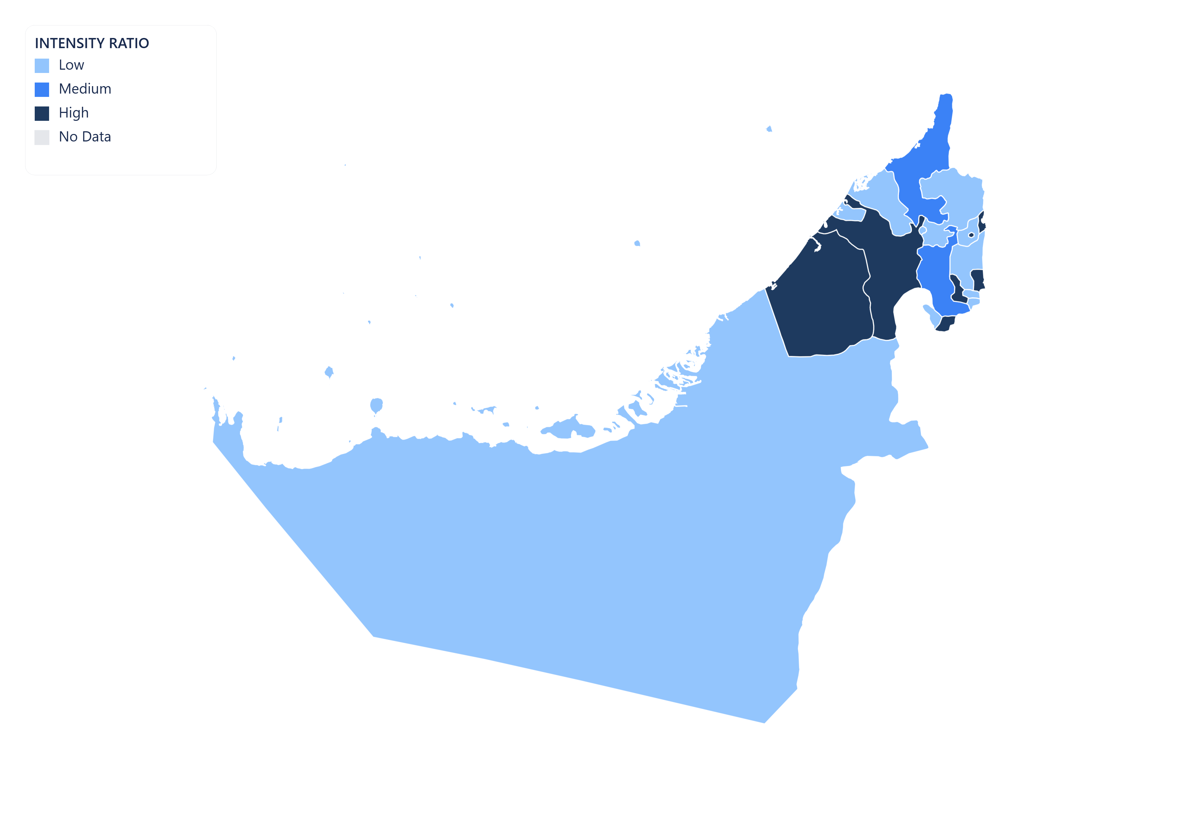
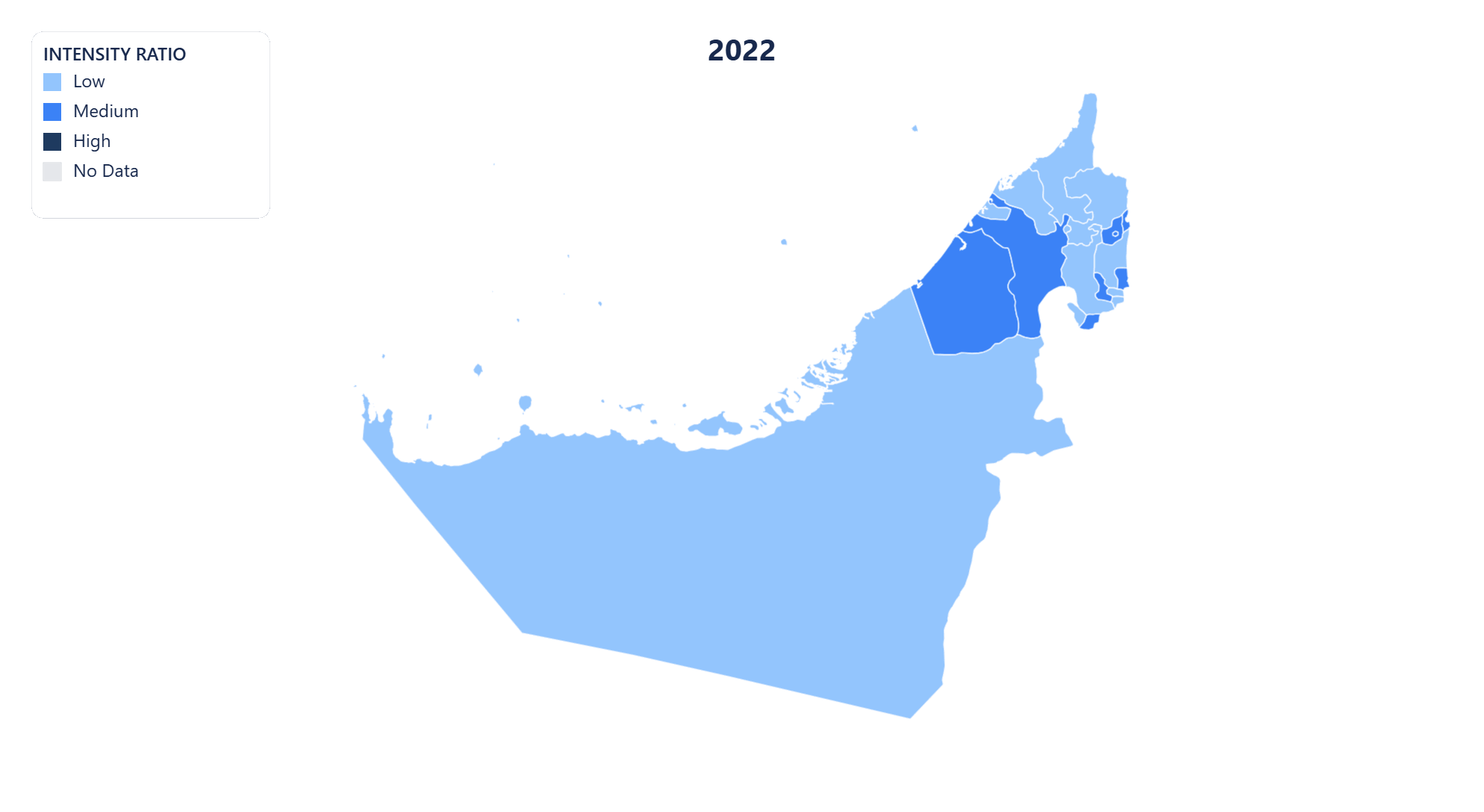
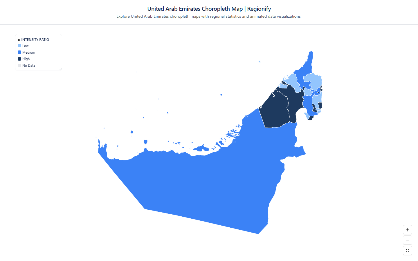
Choropleth Map of United Arab Emirates (الإمارات العربية المتحدة)
Regionify is a choropleth map tool that turns regional data into clear, publish-ready visualizations. Color administrative divisions by any numeric metric — GDP per capita, population density, election results, or your own dataset — then export as PNG, SVG, animated GIF, or an embeddable iframe. No GIS expertise required.
Create your map of United Arab EmiratesWhat you can create for United Arab Emirates with Regionify
From static maps to animated time-series — every format, ready to export.
United Arab Emirates choropleth map
Visualize United Arab Emirates's 10 emirates as a choropleth map. Color regions by any numeric dataset — population, GDP, unemployment, health outcomes, and more. Export as PNG, JPEG, or PDF.
Vector SVG export
Export your United Arab Emirates map as a scalable vector graphic (SVG). Ideal for print publications, editorial illustrations, and web use — scales to any resolution without quality loss.

Animated GIF
Bring your United Arab Emirates data to life. Import historical time-series data and export a looping animated GIF showing how regional values changed over time.
MP4 video export
Export your United Arab Emirates time-series map as an MP4 video. Perfect for presentations, reports, and social media posts where motion communicates change more clearly than static images.
Public share page
Share your United Arab Emirates choropleth map with a public link. Anyone with the URL can view the full interactive map — no account or login required.
Embeddable iframe
Embed your United Arab Emirates choropleth map anywhere with a single line of HTML. The iframe stays live — viewers always see the latest version of your map, no re-publishing needed.
AI-powered data import for United Arab Emirates maps
No spreadsheet? No problem. Regionify's AI Agent turns a plain-text description or raw pasted data into a ready-to-visualize dataset in seconds.
AI Generator
Generate United Arab Emirates data from a prompt
Describe the dataset you need in plain English — for example "GDP per capita of United Arab Emirates's 10 emirates in 2023" or "election results by emirates" — and the AI generates a plausible, structured dataset that maps directly onto United Arab Emirates's administrative boundaries. Edit any values in the table view before saving.
- ✓ Works for population, GDP, health, election, and custom metrics
- ✓ Supports time-series prompts for animated maps
- ✓ Output pre-matched to United Arab Emirates's 10 emirates
AI Parser
Clean and import messy United Arab Emirates data
Paste raw text, a copied Wikipedia table, or an unstructured CSV with regional figures for United Arab Emirates. The AI parser normalises region names, strips noise, resolves mismatched spelling across United Arab Emirates's emirates, and outputs a clean id–label–value table ready to visualise.
- ✓ Handles inconsistent or misspelled emirates names
- ✓ Auto-detects time columns for historical data
- ✓ Streams results in real time as AI processes
AI Agent is available on the Chronographer plan.
Emirates of United Arab Emirates
- 'Ajmān
- Abū Z̧aby
- Dubayy
- Al Fujayrah
- Ra’s al Khaymah
- Ash Shāriqah
- Umm al Qaywayn
- Musandam, Oman
- Neutral Zone
- Neutral Zone
Build your own United Arab Emirates choropleth map — free
Upload any dataset, color United Arab Emirates's emirates by any numeric metric, and export as PNG, SVG, GIF, or MP4. No design skills required — start in seconds, publish anywhere.